U.S. Route 10 in Wisconsin
| |||||||
|---|---|---|---|---|---|---|---|
-map.png) | |||||||
| Route information | |||||||
| Maintained by WisDOT | |||||||
| Length: | 294.01 mi[1] (473.16 km) | ||||||
| Existed: | 1926 – present | ||||||
| Major junctions | |||||||
| West end: |
| ||||||
| East end: |
| ||||||
| Location | |||||||
| Counties: | Pierce, Pepin, Buffalo, Trempealeau, Jackson, Eau Claire, Clark, Wood, Portage, Waupaca, Winnebago, Calumet, Manitowoc | ||||||
| Highway system | |||||||
| |||||||

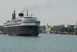
U.S. Highway 10 (US 10) in Wisconsin runs east–west across the central part of the state. It runs from the Prescott Drawbridge over the St. Croix River at Prescott east to the dock in Manitowoc where the SS Badger crosses Lake Michigan to Ludington, Michigan.
Route description
U.S. Highway 10 enters the state and Pierce County from Minnesota at Prescott and immediately joins with WIS 35 north. WIS 35 turns north 1-mile (1.6 km) northeast at WIS 29 while US 10 continues east and passes through Ellsworth at the junctions with WIS 65 and US 63 The highway turns southeast and passes through Ono and Plum City.[2] US 10 then enters Pepin County and junctions with WIS 25 and WIS 85 at Durand[3] US 10 briefly enters Buffalo County and passes through Mondovi at the junction with WIS 37.[4] In northern Trempealeau County, the highway crosses WIS 93 at Eleva, passes through Strum, and junctions with US 53 and I-94 in Osseo.[5] The route then enters Jackson County where it joins US 12 and WIS 27.[6] US 12 and WIS 27 split to the south at the Clark County line while US 10 continues east to Neillsville and crosses WIS 73 there.[7] The highway then meanders northeast into Wood County, passing south of Marshfield and then intersecting with WIS 80. US 10 then meets WIS 13 1 mile south of Marshfield. WIS 13 splits south two miles (3 km) west of Junction City. US 10 then passes north of Auburndale and enters Portage County at Milladore.[8]
US 10 meets WIS 34 and WIS 13 south at two miles (3 km) west of Junction City. WIS 34 splits north two miles (3 km) east of Junction City while US 10 turns east and bypasses Stevens Point on a new freeway. In Stevens Point, the old US 10 has been replaced by WIS 66 which travels through downtown and near the University of Wisconsin–Stevens Point just east of downtown. The highway then meets I-39 / US 51 north of the city and runs concurrent with I-39 / US 51 for about seven miles before exiting to the east of Stevens Point. At this point, US 10 becomes a multilane expressway and heads southeast, passing through Amherst and crossing into Waupaca County.[9] US 10 bypasses the city of Waupaca to the south and junctions with WIS 22, WIS 54 and meets WIS 49 south. US 10 and WIS 49 turn eastward to Weyauwega then head south to Fremont where WIS 49 turns south and US 10 becomes a freeway at the junction with WIS 110.[10] US 10 collects US 45 south in northwest Winnebago County for a three mile (5 km) southeast trek before US 45 splits to the south and US 10 turns east to rendezvous with WIS 441 at the junction with US 41 in Neenah. US 10 turns south off the WIS 441 freeway south of Appleton and turns east into Calumet County.[11]
As a multilane urban arterial, US 10 collects WIS 114 for four miles (6 km) before the latter splits south two miles (3 km) before US 10 junctions with WIS 55. The highway then crosses WIS 32 and WIS 57 at Forest Junction and turns southeast to pass through Brillion and into Manitowoc County.[12] The highway passes through Reedsville and Whitelaw before turning south onto I-43 for three miles (5 km) and turning east off the Interstate to head along WIS 42 into the north side of Manitowoc. US 10 then turns south into downtown where it continues into Michigan via the S.S. Badger carferry to Ludington.[13] The Badger only operates on a seasonal basis from May to October.[14]
History
Prior to 1926, what is now US 10 was State Trunk Highway 18. However, Highway 18 initially (in 1917) only ran from Humbird, near where US 10 and U.S. Highway 12 (then State Trunk Highway 12) cross, east to Manitowoc. State Trunk Highway 34 ran from Prescott to Highway 37 in Mondovi. The route between Mondovi and Humbird was not numbered until the early 1920s, when Highway 18 was extended west from Humbird past Mondovi to Prescott, eliminating Highway 34.[15]
When US 10 was designated in late 1926, it ran along U.S. Highway 12 from Minnesota east to Humbird, splitting there to run to Manitowoc.[16] The piece of former Highway 18 west of Humbird became Highway 34, as the number 18 conflicted with U.S. Highway 18. In 1934, Highway 34 disappeared again, as US 10 was separated from the US 12 concurrency to run along it.[17]
Major intersections
| County | Location | mi[1] | km | Exit | Destinations | Notes |
|---|---|---|---|---|---|---|
| Pierce | Prescott | 0.00 | 0.00 | Continuation into Minnesota; WIS 29 ends at border | ||
| 0.09 | 0.14 | Western end of WIS 35 concurrency | ||||
| 1.32 | 2.12 | Eastern end of WIS 29/WIS 35 concurrency | ||||
| Hager City | 9.12 | 14.68 | ||||
| Trimbelle | 12.16 | 19.57 | ||||
| 13.71 | 22.06 | |||||
| 15.56 | 25.04 | Western end of US 63 concurrency | ||||
| Ellsworth | 17.16 | 27.62 | ||||
| 18.84 | 30.32 | Eastern end of US 63 concurrency | ||||
| Bay City | 22.87 | 36.81 | ||||
| Ono | 33.51 | 53.93 | ||||
| Plum City | 37.24 | 59.93 | ||||
| Pepin | Arkansaw | 47.19 | 75.94 | Western end of WIS 25 concurrency | ||
| Durand | 48.16 | 77.51 | Eastern end of WIS 25 concurrency | |||
| 49.66 | 79.92 | |||||
| Buffalo | Mondovi | 64.82 | 104.32 | Western end of WIS 37 concurrency | ||
| 65.54 | 105.48 | Eastern end of WIS 37 concurrency | ||||
| Trempealeau | Eleva | 74.89 | 120.52 | |||
| Osseo | 85.18 | 137.08 | Western end of US 53 concurrency | |||
| 87.60 | 140.98 | Eastern end of concurrency | ||||
| 88.52 | 142.46 | I-94 exit 88 | ||||
| Jackson | Fairchild | 101.39 | 163.17 | Western end of US 12 concurrency | ||
| 103.28 | 166.21 | Eastern end of US 12 concurrency | ||||
| Clark | Neillsville | 120.13 | 193.33 | |||
| Granton | 127.41 | 205.05 | Western end of CTH-K concurrency | |||
| 128.54 | 206.87 | Eastern end of CTH-K concurrency | ||||
| Wood | Marshfield | 142.99 | 230.12 | Western end of WIS 13 concurrency | ||
| 144.97 | 233.31 | |||||
| 146.95 | 236.49 | Eastern end of concurrency | ||||
| Hewitt | 148.90 | 239.63 | ||||
| Auburndale | 152.41 | 245.28 | ||||
| Milladore | 160.72 | 258.65 | ||||
| Portage | Junction City | 163.62 | 263.32 | Western end of WIS 34 concurrency | ||
| 165.14 | 265.77 | |||||
| 166.65 | 268.20 | |||||
| 168.04 | 270.43 | Eastern end of WIS 34 concurrency | ||||
| Stevens Point | 176.41 | 283.90 | ||||
| 177.56 | 285.76 | |||||
| 178.06 | 286.56 | |||||
| 179.94 | 289.59 | — | I-39 Exit 158 | |||
| Stockton | 183.95 | 296.04 | — | |||
| Custer | 188.50 | 303.36 | At-grade intersection western end of CTH-K concurrency | |||
| Stockton | 191.20 | 307.71 | At-grade intersection | |||
| 191.90 | 308.83 | At-grade intersection | ||||
| Amherst Junction | 190.94 | 307.29 | — | Amherst Junction, Lake Drive | Eastbound exit; Westbound entrance only | |
| Amherst | 192.51 | 309.81 | — | Western end of CTH-B concurrency | ||
| 194.51 | 313.03 | — | Eastern end of CTH-B concurrency | |||
| Waupaca | Sheridan | 200.89 | 323.30 | At-grade intersection | ||
| Waupaca | 204.69 | 329.42 | 250 | Western end of WIS 49/WIS 54 concurrency | ||
| 205.97 | 331.48 | 252 | Western end of WIS 22 concurrency | |||
| 207.38 | 333.75 | 253 | Churchill Street | |||
| 208.66 | 335.81 | 254 | Eastern end of WIS 22/WIS 54 concurrency | |||
| Weyauwega | 213.95 | 344.32 | 260A | Western end of WIS 110 concurrency | ||
| 214.92 | 345.88 | 260B | Westbound exit and eastbound entrance | |||
| Fremont | 218.73 | 352.01 | 264 | Eastern end of WIS 49/WIS 110 concurrency | ||
| 221.77 | 356.90 | 267 | ||||
| Winnebago | Winchester | 228.02 | 366.96 | 273 | ||
| 230.59 | 371.10 | 276 | Eastern end of US 45 concurrency | |||
| Neenah | 238.10 | 383.18 | 284 | Eastbound also signed To US 41 north | ||
| 240.54 | 387.11 | 286 | ||||
| 241.68 | 388.95 | — | Western terminus of WIS 441 concurrency | |||
| 241.68 | 388.95 | 287 | ||||
| Menasha | 242.64 | 390.49 | — | |||
| 243.75 | 392.28 | — | ||||
| 244.91 | 394.14 | — | ||||
| Calumet | Waverly Beach | 245.91 | 395.75 | — | Eastern end of WIS 441 concurrency | |
| 247.39 | 398.14 | Western end of WIS 114 concurrency | ||||
| Highland Beach | 250.88 | 403.75 | Eastern end of WIS 114 concurrency | |||
| 255.50 | 411.19 | |||||
| Forest Junction | 261.90 | 421.49 | Western end of WIS 32/WIS 57 concurrency | |||
| 262.40 | 422.29 | Eastern end of WIS 32/WIS 57 concurrency | ||||
| Brillion | 267.23 | 430.06 | ||||
| Manitowoc | Reedsville | 272.53 | 438.59 | |||
| Cato | 277.89 | 447.22 | ||||
| Whitelaw | 279.91 | 450.47 | ||||
| Manitowoc | 284.70 | 458.18 | Western end of I-43 concurrency; exit unnumbered eastbound | |||
| 287.75 | 463.09 | 154 | Eastern end of I-43 concurrency; western end of WIS 42 concurrency; exit unnumbered westbound | |||
| 291.40 | 468.96 | 152 | Eastern end of WI 42 concurrency | |||
| 292.86 | 471.31 | |||||
| 294.01 | 473.16 | Carferry crosses Lake Michigan to US 10 in Michigan | ||||
1.000 mi = 1.609 km; 1.000 km = 0.621 mi
| ||||||
Future
There has been a plan suggested to upgrade the U.S. 10 section between Marshfield and Neillsville to expressway status
See also
- U.S. Route 110, a short and short-lived spur from Fremont to Oshkosh
References
- ↑ 1.0 1.1 Street Atlas USA 2007 (Map). DeLorme. 2007.
- ↑ Pierce County (PDF) (Map). Cartography by WisDOT. Wisconsin Department of Transportation. Retrieved December 29, 2007.
- ↑ Pepin County (PDF) (Map). Cartography by WisDOT. Wisconsin Department of Transportation. Retrieved December 29, 2007.
- ↑ Buffalo County (PDF) (Map). Cartography by WisDOT. Wisconsin Department of Transportation. Retrieved December 29, 2007.
- ↑ Trempealeau County (PDF) (Map). Cartography by WisDOT. Wisconsin Department of Transportation. Retrieved December 29, 2007.
- ↑ Jackson County (PDF) (Map). Cartography by WisDOT. Wisconsin Department of Transportation. Retrieved December 29, 2007.
- ↑ Clark County (PDF) (Map). Cartography by WisDOT. Wisconsin Department of Transportation. Retrieved December 29, 2007.
- ↑ Wood County (PDF) (Map). Cartography by WisDOT. Wisconsin Department of Transportation. Retrieved December 29, 2007.
- ↑ Portage County (PDF) (Map). Cartography by WisDOT. Wisconsin Department of Transportation. Retrieved December 29, 2007.
- ↑ Waupaca County (PDF) (Map). Cartography by WisDOT. Wisconsin Department of Transportation. Retrieved December 29, 2007.
- ↑ Winnebago County (PDF) (Map). Cartography by WisDOT. Wisconsin Department of Transportation. Retrieved December 29, 2007.
- ↑ Calumet County (PDF) (Map). Cartography by WisDOT. Wisconsin Department of Transportation. Retrieved December 29, 2007.
- ↑ Manitowoc County (PDF) (Map). Cartography by WisDOT. Wisconsin Department of Transportation. Retrieved December 29, 2007.
- ↑ "S.S. Badger History". Retrieved September 28, 2014.
- ↑ Bessert, Christopher J. (February 6, 2007). "Highways 30-39". Wisconsin Highways. Self-published. Retrieved March 20, 2007.
- ↑ United States System of Highways (Map). Cartography by American Association of State Highway Officials. Bureau of Public Roads. November 11, 1926. Retrieved March 20, 2007.
- ↑ Bessert, Christopher J. (February 6, 2007). "Highways 10-19". Wisconsin Highways. Self-published. Retrieved March 20, 2007.
External links
Route map: Bing
 Media related to U.S. Route 10 in Wisconsin at Wikimedia Commons
| Previous state: Minnesota |
Wisconsin | Next state: Michigan |