Učka
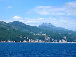
The Učka is a mountain range (Croatian: Učka; Italian: Monte Maggiore) that rises behind Opatija riviera, on the Istrian peninsula, in northwestern Croatia. It forms a single morphological unit together with the Ćićarija range which stretches from the Bay of Trieste to Rijeka. Učka is a limestone massif with numerous areas of karst, stretching for 20 km from the Poklon Pass (920 m) to Plomin Bay, and is between 4 and 9 km wide.[1]
It differs from all the other coastal mountains in Croatia because of its abundant vegetation on the seaward side. Best known are the forests of sweet chestnuts in the area around Lovran.
Učka's highest peaks are considered nature reserves and memorial areas. The highest peak, Vojak, is located at 1396 meters above sea level.[2] From it there is a magnificent view over the whole of Istria, the Bay of Trieste, the Julian Alps and the Adriatic islands, right down to Dugi Otok.[1]
The subject of a degree of local folklore, Učka is visible from much of the peninsula and is snow-capped some months of the year. The town of Opatija (Italian: Abbazia) is said to have derived its popularity as a resort in Imperial Austria because it is located "in the shade" of Mt. Učka, which by legend shields it from the fierce Mediterranean heat in summertime.
The area of Učka is designated a nature park (park prirode), a kind of protected area in Croatia.
References
- ↑ 1.0 1.1 Naklada Naprijed, The Croatian Adriatic Tourist Guide, pg. 89, Zagreb (1999), ISBN 953-178-097-8
- ↑ "Geographical and meteorological data". Statistical Yearbook. Croatian Bureau of Statistics. 2009. Retrieved 2011-09-19.
External links
| Wikimedia Commons has media related to Učka. |
Coordinates: 45°15′N 14°12′E / 45.250°N 14.200°E
| ||||||||||