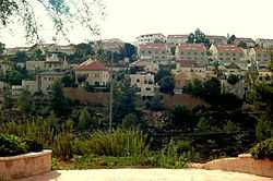
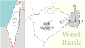
Tzur Hadassah
| Tzur Hadassah | |
|---|---|
 | |
 Tzur Hadassah | |
| Coordinates: 31°43′9.17″N 35°5′51.46″E / 31.7192139°N 35.0976278°ECoordinates: 31°43′9.17″N 35°5′51.46″E / 31.7192139°N 35.0976278°E | |
| Council | Mateh Yehuda |
| Region | Jerusalem corridor |
| Founded | 1960 |
| Population | 8,000 |
Tzur Hadassah (Hebrew: צוּר הֲדַסָּה, lit. Rock of Hadassah) is a communal settlement in central Israel. It is located in the Judean Hills around 12 kilometres (7.5 mi) west of Jerusalem and falls under the jurisdiction of Mateh Yehuda Regional Council. In 2014, it had a population of 8,000 people with a large proportion of children.[1] Tzur Hadassah was established in 1960 as a regional centre for nearby moshavim such as (Bar Giora, Mata, Mevo Beitar and Nes Harim). It was named for the Hadassah organization.
The town has three neighborhoods: Old Tzur Hadassah (Shechunat HaMeah); New Tzur Hadassah (Shechunat HaEmek); and Har Kitron, which forms the second half of the horseshoe topography of Tzur Hadassah.[2]
The Harei Yehuda riding stable is located in Tzur Hadassah, at the edge of the Sansan nature reserve. It was established in 1991 in the old part of Tzur Hadassah and moved to new facilities in 2004.[3]The Israel National Trail, marked with orange, blue, and white stripes, reaches Tzur Hadassah on its way westward.[4]In 2014, construction workers discovered a large stalactite cave near Tzur Hadassah.[5]