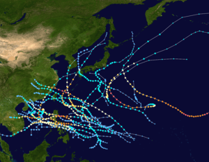
Typhoon Utor (2006)
| Typhoon (JMA scale) | |
|---|---|
| Category 3 (Saffir–Simpson scale) | |
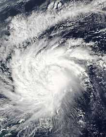
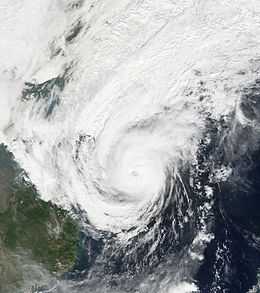 Utor following peak intensity on December 13 in the South China Sea | |
| Formed | December 7, 2006 |
| Dissipated | December 15, 2006 |
| Highest winds |
10-minute sustained: 155 km/h (100 mph) 1-minute sustained: 185 km/h (115 mph) [1] Gusts: 230 km/h (145 mph) |
| Lowest pressure | 945 mbar (hPa); 27.91 inHg |
| Fatalities | 38 total |
| Damage | $15.8 million (2006 USD) |
| Areas affected | Philippines, Paracel Islands, Malaysia |
| Part of the 2006 Pacific typhoon season | |
Typhoon Utor, known in the Philippines as Typhoon Seniang,[2] swept through the central Philippines in December 2006, exacerbating the damage left behind by previous Philippine typhoon strikes that year. Residual moisture from the tropical cyclone indirectly contributed to extensive flooding in Malaysia. Utor originated from an area of disturbed weather that organized into a tropical depression on December 7 west-southwest of Yap. The cyclone steadily progressed westward while gradually intensifying, reaching tropical storm intensity late on December 7. On December 9 and the ensuing two days, Utor crossed the central Philippines and reached typhoon strength before weakening somewhat upon entry into the South China Sea. Reintensification ensued afterwards, and Utor reached its peak intensity on December 13 with maximum sustained winds of 155 km/h (100 mph) shortly after regaining typhoon strength.[nb 1] However, wind shear and dry air began to take its toll on Utor thereafter, quickly weakening the storm until its dissipation on December 15.
Due to the destruction wrought by Typhoon Durian just weeks prior, preparations began in earnest in the Philippines. Over 91,000 people were evacuated from areas at risk, primarily from Albay. Two major summits to be held in Cebu were postponed as a result of the forecast inclement weather. In addition, recovery efforts for victims of Durian had to be suspended and all domestic flights in the Philippines were cancelled. Utor's impacts in the central Philippines were extensive, with 30 casualties reported and the damage toll reaching US$15.8 million.[4] Widespread power outages affected the entirety of Eastern Visayas. Numerous ships sunk as a result of rough seas generated by the typhoon, including a ferry carrying 104 passengers and crew. Following the storm, relief agencies began to allocate resources to those affected by the typhoon, in turn also adding to relief efforts for the three Philippine typhoons which preceded Utor. Precautionary efforts also took place in Vietnam, Thailand, and Malaysia, while the Paracel Islands sustained marked damage but no fatalities. Although the storm mostly dissipated in the South China Sea, Utor's remnant moisture later contributed in part to Peninsular Malaysia's worst flood event in recorded history, as copious amounts of precipitation fell over a short, four day period. Eight people were killed by the floods which were worst in Kota Tinggi and Segamat District.
Meteorological history
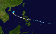
The predecessor to Typhoon Utor was first noted by the Joint Typhoon Warning Center (JTWC) as a cluster of thunderstorms southeast of Chuuk on December 2.[nb 2] Over the next few days, a center of circulation accompanied by intermittent shower activity began to develop in the presence of favorable conditions.[2] At 00:00 UTC on December 7, the Japan Meteorological Agency (JMA) determined that the disturbance had become sufficiently organized to be considered a tropical depression;[6][nb 3] at the time the cyclone was centered 175 km (110 mi) west-southwest of Yap. Tracking westward under the influence of a powerful subtropical ridge to its north, the depression strengthened into a tropical storm at 18:00 UTC. In accordance, the storm was given the name Utor; this name had been submitted by the United States and means "squall line".[2]
Utor's development following its naming was slow, but quickened as the tropical storm neared the Philippines. The tropical cyclone reached the southeastern coast of Samar by 06:00 UTC on December 9 and began tracking through the central Philippine archipelago over the next two days. Despite its interaction with the nearby islands,[2] Utor continued to strengthen without much impediment and reached typhoon strength in the Visayan Sea at 12:00 UTC that day. Twelve hours later, the typhoon attained an initial peak intensity with maximum sustained winds of 140 km/h (85 mph) and a minimum barometric pressure of 955 mbar (hPa; 28.20 inHg) in the Sibuyan Sea according to the JMA.[6] The JTWC analyzed an intensity of (185 km/h) 115 mph at that time.[2] By 12:00 UTC on December 10, Utor had emerged into the South China Sea.[6]
Although Utor tracked back over water on December 10, the storm began to weaken due to increasing wind shear and dry air from the west.[2] As a result, the JMA downgraded Utor to severe tropical storm intensity upon its emergence into the South China Sea.[6] Despite these hindering conditions, the storm's improved outflow was sufficient enough to enable redevelopment.[2] At 18:00 UTC on December 11, the JMA once again upgraded the system to typhoon strength southeast of Hainan. Intensification continued until Utor peaked with winds of 155 km/h (100 mph) and a minimum pressure of 945 mbar (hPa; 27.91 inHg) the next day.[6] This strength was held for only twelve hours before Utor's outflow began to succumb to the wind shear and dry air stemming from the monsoonal flow it had previously suppressed.[2][7] Traveling in a tight clockwise loop, the typhoon rapidly weakened on December 13; by the following day Utor was a minimal tropical storm. At 06:00 UTC on December 14, the storm degenerated into a tropical depression and continued to execute a small anticyclonic loop before dissipating on December 15. [6]
Preparations, impact, and aftermath
Philippines
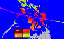
Although the Philippine Atmospheric, Geophysical and Astronomical Services Administration (PAGASA) did not recommend their delay,[8] both the 2006 ASEAN and East Asia summits in Cebu City were postponed due to the threat of Utor impacting the city; officials denied allegations that the postponements were instead due to a possible terrorist attack.[9] This was the first time than an ASEAN summit had been postponed due to inclement weather.[10] Potentially hazardous conditions also delayed humanitarian aid to victims of Typhoon Durian, which struck the Philippines in late November.[11] The first Public Storm Warning Signals for the Philippines were issued by the PAGASA on December 8 for several islands in the central Philippines.[12] The third level of the four-tier warning system was issued for Samar, Leyte, and Biliran.[13] With landfall imminent on December 9, 15,000 people were evacuated to temporary evacuation shelters from around 12 villages.[14] This figure increased to 59,000 people as landfall occurred and later to 91,121 with the storm passing over the Philippines.[15] Most of the evacuees were from Albay due to fears of deadly mudslides and lahars associated with Mount Mayon as witnessed during Typhoon Durian.[16][17] In addition, the Philippines Office of Civil Defense considered relocating Typhoon Durian refugees in the Bicol Region to special "holding areas".[18] Other domestic flights were also cancelled.[19]
Utor caused extensive power outages in Cebu, Leyte, and Boracay,[15] resulting in widespread loss of telecommunication.[20] A single electric pole in northern Cebu caught fire during the storm, cutting out power to eight peripheral towns. Downtown Tacloban also suffered a blackout.[21] Off of Boracay, a boat operator was killed after their ship capsized.[15] Another 67 ships, which consisted of speedboats and ferries, sunk during the storm's passage.[22] Buildings were unroofed and trees were torn apart on the island, littering its beaches with debris.[20] A barge was forced by large waves into the pier at San Agustin, Romblon, resulting in the spilling of 25,000 L (6,600 gal) of diesel fuel.[23] Two children were killed in Tacloban and Capiz as a result of falling trees; an additional three people in Capiz were feared to have drowned due to floods.[15] Two thousand people became stranded after the Philippine Coast Guard cancelled the operation of 43 ferry services.[24] Similarly, 8,000 people became stranded at seaports after the coast guard barred vessels from sailing.[25] Extensive damage occurred in Occidental Mindoro, where 422 homes were destroyed and an additional 1,421 damaged.[26] Rough seas caused the outriggers on a ferry between Batangas and Puerto Galera, Oriental Mindoro to break apart, causing the ship to begin disintegrating offshore. However, the 104 passengers and crew on board were able to escape and were later rescued.[27] Further north in southern Luzon, roads and bridges were rendered impassable after sustaining damage.[28]
A state of emergency was declared for Aklan, where property damage equated to ₱51 million (US$1 million).[29][nb 4] The Central Visayas region of the Philippines suffered the worst impacts, with a damage cost of ₱345.2 million (US$7 million), primarily to agriculture.[nb 4][30] Following the storm's passage, chapters of the Philippine Red Cross assisted in relief efforts in impacted areas.[31] The Philippine Department of Social Welfare and Development allocated ₱27.7 million (US$600,000) to relief efforts.[nb 4][32] Food and sheltering were provided to 2,615 people in three provinces by the Adventist Development and Relief Agency.[33] Many localized relief agencies donated sacks of rice to impacted residents.[34] The United Nations appealed for US$46 million for use in recovery efforts following Utor in addition to the three Philippine typhoons which preceded it.[17] Overall, the impacts of Utor killed 30 people and injured 44 in the Philippines. Another eight people were never accounted for. The damage toll wrought by Utor amounted to US$15.8 million.[35] Furthermore, 36,542 houses were damaged by Utor, of which 9,439 were destroyed. Capiz and Aklan were the areas that sustained the most residential damage. People who were evacuated out of hazardous regions in advance of Utor were able to return home beginning on December 18,[36] nine days after initial landfall.[2]
Elsewhere in Southeastern Asia
Thailand's Royal Irrigation Department released water from local dams in order to mitigate a potential flood event caused by Utor. Flooded areas of the western half of the country drained floodwaters into the Chao Phraya River.[37] Off of Malaysia, a rough sea warning for coastal stretches of Sabah and northern Sarawak due to the threat of high wind-swept waves caused by Utor.[38] In Vietnam, delegations were sent to coastal areas to guide residents in preparing for Utor and secure fishing boats, while troops were sent to reinforce buildings and fortify sea defenses.[39] Preparations for "mass evacuations" also went into effect, particularly along Vietnam's central coastline.[39] Border guards called back 3,785 fishing vessels with over 21,000 fishermen to shore.[40] Aircraft, automobiles, canoes, and ships were dispatched into threatened areas to disseminate information regarding the typhoon.[41] Similar precautionary measures took place in Hainan, where more than 20,000 fishing boats were called back to shore.[42] Forty-nine people were evacuated out of the Paracel Islands due to the threat of the typhoon.[43]
As Utor was traversing the South China Sea, a fishing boat became stranded near Langhua Reef in the Paracel Islands; the occupants were rescued by a rescue ship operated by the Hainan Maritime Bureau,[44] though five were flown to hospitals for medical treatment.[45] A total of 140 sheds on the islands of Yongxing, Yayong, Zhaoshu, and Bei Dao were flattened by the passing typhoon, while a ship at harbor sank and five others ran aground.[43] On the Qilian Yu island sub-group, 98 fishermen on the islands were rescued by the Nanhai Rescue Bureau following days without clean water and food supplies. Utor had destroyed all of the islands' bunkhouses, resulting in requests for rescue.[46]
Moisture associated with Utor was partially blamed for heavy rains which produced extensive flooding in Peninsular Malaysia;[47] these floods were the first in a long string of flood events that would plague the region until February 2007.[48] The tropical moisture acted in tandem with wind shear and a monsoonal flow to produce continuous precipitation over the Malaysian states of Pahang, Johor, and Malacca. Rainfall peaked at 567.8 mm (22.35 in) in Bandar Muadzam Shah over a four day period, with similar rainfall totals occurring elsewhere.[49] These floods were considered the worst in the history of southern Malaysia.[50] The worst-affected areas were Segamat and Kota Tinggi, where both towns were inaccessible by land after all main roads leading to those towns were flooded.[51] Eight fatalities resulted from the historical flooding.[52]
See also
- Typhoons in the Philippines
- Typhoon Axel (1994) – Late-year typhoon which passed through the central Philippines
- Typhoon Faith (1998) – Displaced several thousand people after ravaging the central Philippines
- Typhoon Nepartak (2003) – Caused extensive power outages and agricultural damage in the Philippines before peaking in the South China Sea
- Typhoon Haiyan, a storm with a nearly similar track, was the costliest natural disaster in Philippine history, significantly impacting Central Philippines
Notes
- ↑ Sustained is measured or estimated as the average of wind velocities at any one location over a ten minute period unless otherwise noted.[3]
- ↑ The Joint Typhoon Warning Center is a joint United States Navy – United States Air Force task force that issues tropical cyclone warnings for the western Pacific Ocean and other regions.[5]
- ↑ The Japan Meteorological Agency is the official Regional Specialized Meteorological Center for the western Pacific Ocean.[6]
- ↑ 4.0 4.1 4.2 The total was originally reported in Philippine pesos, and was converted to United States dollars via the Oanda Corporation website.[4]
References
- ↑ Joint Typhoon Warning Center; O'Hara, J.F.; Falvey, Robert (2006). Lana, Aaron D., ed. 2006 Annual Tropical Cyclone Report (PDF) (Report). Pearl Harbor, Hawaii: United States Naval Maritime Forecast Center. p. 70. Retrieved October 15, 2014.
- ↑ 2.0 2.1 2.2 2.3 2.4 2.5 2.6 2.7 2.8 Padgett, Gary (March 4, 2007). "Monthly Global Tropical Cyclone Summary December 2006". Australiansevereweather.com. Retrieved October 15, 2014.
- ↑ Secretariat Of The World Meteorological Organization (2012). Typhoon Committee Operational Manual (PDF) (Report). Geneva, Switzerland: World Meteorological Organization. p. 3. Retrieved October 15, 2014.
- ↑ 4.0 4.1 "Historical Exchange Rates". Oanda Corporation. 2014. Retrieved October 19, 2014.
- ↑ "Joint Typhoon Warning Center Mission Statement". Pearl Harbor, Hawaii: Joint Typhoon Warning Center. 2007. Archived from the original on July 26, 2007. Retrieved October 15, 2014.
- ↑ 6.0 6.1 6.2 6.3 6.4 6.5 6.6 Japan Meteorological Agency (2006). Annual Report on the Activities of the RSMC Tokyo – Typhoon Center 2006 (PDF) (Report). Tokyo, Japan: Ministry of Land, Infrastructure, Transport and Tourism. p. 45. Retrieved October 15, 2014.
- ↑ Hong Kong Observatory (June 2007). "Tropical Cyclones in 2006" (PDF). Kowloon, Hong Kong: Government of Hong Kong. p. 33. Retrieved October 15, 2014.
- ↑ "Weather bureau did not push for ASEAN Summit postponement". Manila, Philippines. Xinhua News Agency. December 8, 2006 – via LexisNexis. (subscription required)
- ↑ Alexander, Paul (December 8, 2006). "2 Asian Summits Postponed by Storms". The Washington Post (Cebu, Philippines: The Washington Post). Associated Press. Retrieved October 18, 2014.
- ↑ "M'sians Evacuated From Cebu City Over Fears Of Impending Storm". Cebu, Philippines. Malaysia General News. December 9, 2006 – via LexisNexis. (subscription required)
- ↑ "Typhoon Utor Impedes Durian Aid Delivery". Labuan, Malaysia. Malaysia General News. December 9, 2006 – via LexisNexis. (subscription required)
- ↑ "Tropical storm Utor strengthens, poses threat to ASEAN Summit". Manila, Philippines. Xinhua News Agency. December 8, 2006 – via LexisNexis. (subscription required)
- ↑ "Tropical storm Seniang maintains strength as it nears Philippines". Manila, Philippines. Xinhua News Agency. December 9, 2006 – via LexisNexis. (subscription required)
- ↑ "Mass Evacuation Ordered in Philippines". Manila, Philippines. Associated Press. December 9, 2006 – via LexisNexis. (subscription required)
- ↑ 15.0 15.1 15.2 15.3 Teves, Oliver (December 10, 2006). "Typhoon Utor Lashes Philippines; 3 Dead". Manila, Philippines. Associated Press. Retrieved October 18, 2014.
- ↑ "Two dead, more than 91,000 evacuated in Philippine Typhoon". Manila, Philippines. Deutsche Presse-Agentur. December 10, 2006 – via LexisNexis. (subscription required)
- ↑ 17.0 17.1 United Nations Office for the Coordination of Humanitarian Affairs (December 131, 2006). United Nations supports Philippines with emergency funding (Report). ReliefWeb. Retrieved October 18, 2014. Check date values in:
|date=(help) - ↑ "Tropical storm heads towards Philippines". Cebu, Philippines. Agence France-Presse. December 9, 2006 – via LexisNexis. (subscription required)
- ↑ "Typhoon wreaks havoc in Philippines". Australian Broadcasting Corporation. Australian Broadcasting Corporation. December 9, 2006. Retrieved October 19, 2014.
- ↑ 20.0 20.1 "Typhoon roars out of Philippines, 4 killed". Manila, Philippines: ReliefWeb. Reuters. December 11, 2006. Retrieved October 18, 2014.
- ↑ Pagliawan, Lemuel L. (December 1, 2006). "Typhoon Seniang whips Visayas; Albay residents evacuated". BusinessWorld. Reuters. pp. S1–S2 – via LexisNexis. (subscription required)
- ↑ "Philippines resort island hit hard by typhoon". Boracay, Philippines: Philippine Daily Inquirer. Agence France-Presse. December 11, 2006. Retrieved October 18, 2014.
- ↑ Cerojano, Teresa (December 11, 2006). "Typhoon Utor hits Philippines, four dead". Manila, Philippines: The Sydney Morning Herald. Associated Press. Retrieved October 18, 2014.
- ↑ Teves, Oliver (December 10, 2006). "Another Typhoon Hits the Philippines". Manila, Philippines. Associated Press – via LexisNexis. (subscription required)
- ↑ "One killed, more than 66,000 evacuated in Philippine typhoon". Manila, Philippines. Deutsche Presse-Agentur. December 10, 2006 – via LexisNexis. (subscription required)
- ↑ Rabonza, Glenn J. (December 10, 2006). NDCC Media Update (10 December 2006) (PDF) (Report). Manila, Philippines: ReliefWeb. Retrieved October 18, 2014.
- ↑ "104 rescued as Philippines ferry sinks in stormy waters". Manila, Philippines. Agence France-Presse. December 11, 2006 – via LexisNexis. (subscription required)
- ↑ "Death toll rises to 17 in Philippines after typhoon Utor". Manila, Philippines. Xinhua News Agency. December 13, 2006 – via LexisNexis. (subscription required)
- ↑ Philippine National Red Cross (December 11, 2006). Philippines: Typhoon Seniang slams into Mindoro and the Calamian Islands (Report). ReliefWeb. Retrieved October 18, 2014.
- ↑ Rabonza, Glenn J. (December 12, 2006). NDCC Media Update (12 December 2006) (PDF) (Report). Manila, Philippines: ReliefWeb. Retrieved October 18, 2014.
- ↑ Philippine National Red Cross (December 11, 2006). Philippines: Typhoon "Seniang (Utor)" Disaster Bulletin #09 (Report). ReliefWeb. Retrieved October 18, 2014.
- ↑ Rabonza, Glenn J. (December 11, 2006). NDCC Media Update (11 December 2006) (PDF) (Report). Manila, Philippines: ReliefWeb. Retrieved October 18, 2014.
- ↑ Adventist Development and Relief Agency (December 18, 2006). Philippines: Assistance for Typhoon Seniang survivors (Report). ReliefWeb. Retrieved October 18, 2014.
- ↑ Rabonza, Glenn J. (December 13, 2006). NDCC Media Update (13 December 2006) (PDF) (Report). Manila, Philippines: ReliefWeb. Retrieved October 19, 2014.
- ↑ Severe Weather Information Centre (November 19, 2007). "Overview of Meteorological and Hydrological Conditions during the Year" (PDF). Geneva, Switzerland: World Meteorological Organization. Retrieved October 18, 2014.
- ↑ Government of the Philippines (December 18, 2006). Philippines: "Seniang" evacuees back to their homes (Report). Manila, Philippines: ReliefWeb. Retrieved October 19, 2014.
- ↑ "Thailand: RID prepares for Typhoon Utor". Thai News Service. December 11, 2006 – via LexisNexis. (subscription required)
- ↑ "Rough Seas Warning In Sabah, Sarawak". Kuala Lumpur, Malaysia. Malaysia General News. December 11, 2006 – via LexisNexis. (subscription required)
- ↑ 39.0 39.1 "Vietnam prepares for typhoon Utor". Hanoi, Vietnam. Deutsche Presse-Agentur. December 11, 2006 – via LexisNexis. (subscription required)
- ↑ "Vietnam: Central provinces prepared to cope with Typhoon Utor". Thai News Service. December 12, 2006 – via LexisNexis. (subscription required)
- ↑ "Vietnam braces for approaching typhoon Utor". Hanoi, Vietnam. Xinhua News Agency. December 13, 2006 – via LexisNexis. (subscription required)
- ↑ "Typhoon Utor to bring rainstorms to China's island province". Haikou, China: China Internet Information Center. Xinhua News Agency. December 13, 2006. Retrieved October 19, 2014.
- ↑ 43.0 43.1 "Typhoon Utor rips through south China islands". Beijing, China: China Radio International. Xinhua News Agency. December 15, 2006. Retrieved October 19, 2014.
- ↑ "17 Chinese fishermen stranded in Typhoon Utor". Beijing, China: China Radio International. Xinhua News Agency. December 14, 2006. Retrieved October 19, 2014.
- ↑ "16 Chinese fishermen rescued, one still missing in the wake of Typhoon Utor". Haikou, China: China Radio International. Xinhua News Agency. December 14, 2006. Retrieved October 19, 2014.
- ↑ "Nearly one hundred fishermen short of water, food on south China islands saved". Haikou, China: China Radio International. Xinhua News Agency. December 19, 2006. Retrieved October 19, 2014.
- ↑ "Dangerous Waters". New Straits Times. December 22, 2006 – via LexisNexis. (subscription required)
- ↑ Kusumastuti, Dyah Indriana (December 2007). "Hydrology Analysis For The Johor River Using Synthetic Unit Hydrograph Gama I" (PDF). Jurnal Rekayasa (Bandar Lampung, Indonesia: Lampung University) 13 (3). Retrieved October 19, 2014.
- ↑ Malaysian Meteorological Department; Ministry of Science, Technology and Innovation (December 21, 2006). "Report On Heavy Rainfall That Caused Floods In Johor, Melaka, Negiri, Sembilan And Pahang During The Period 17th – 20th December 2006" (PDF). ReliefWeb. Retrieved October 19, 2014.
- ↑ "Typhoon Utor to blame". Cyberjaya, Malaysia: Star Publications. December 21, 2006. Retrieved October 23, 2014.
- ↑ "Segamat and Kota Tinggi folks stranded by floods". Star Publications. December 21, 2006. Retrieved October 23, 2014.
- ↑ "Extending a helping hand". Malacca City, Malaysia: Star Publications. December 24, 2006. Retrieved October 23, 2014.
External links
| Wikimedia Commons has media related to Typhoon Utor (2006). |
- JMA General Information of Typhoon Utor via Digital Typhoon
- JMA Best Track Data of Typhoon Utor (Japanese)
- JTWC Best Track Data of Typhoon 25W (Utor)
- Typhoon Utor satellite imagery archive from the U.S. Naval Research Laboratory
| |||||||||||||
