Typhoon Dujuan (2003)
| Typhoon (JMA scale) | |
|---|---|
| Category 4 (Saffir–Simpson scale) | |
 Typhoon Dujuan nearing peak intensity | |
| Formed | August 27, 2003 |
| Dissipated | September 3, 2003 |
| Highest winds |
10-minute sustained: 150 km/h (90 mph) 1-minute sustained: 230 km/h (145 mph) |
| Lowest pressure | 950 mbar (hPa); 28.05 inHg |
| Fatalities | 44 dead |
| Damage | $392 million (2003 USD) |
| Areas affected | Philippines, Okinawa, Taiwan, China |
| Part of the 2003 Pacific typhoon season | |
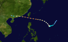
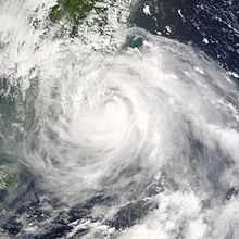
Typhoon Dujuan, known in the Philippines as Typhoon Onyok,[1] was the strongest tropical cyclone to strike the Pearl River delta since Typhoon Hope in 1979. The 13th storm and 7th typhoon of the 2003 Pacific typhoon season, Dujuan developed on August 27 to the east of Taiwan. It initially moved to the northwest, slowly intensifying into a tropical storm while drawing moisture and rainfall over the Philippines. On the island of Luzon, one person was killed and areas were flooded. Dujuan quickly intensified after turning and moving quicker to the west-northwest, developing an eye. It reached peak winds of 150 km/h (90 mph) on September 1, and shortly thereafter passed just south of Taiwan. There, Dujuan left 590,000 people without power, killed three, and caused NT$200 million (NWD, $115 million USD) in crop damage.[nb 1] While moving through the South China Sea, the typhoon developed concentric eyewalls. Dujuan weakened to severe tropical storm status before making landfall on September 2 in southern China, just east of Hong Kong near Shenzhen, Guangdong. The storm dissipated the next day after causing 40 deaths and ¥2.3 billion (CNY, $277 million USD) in damage. Most of the deaths were in Shenzhen where the storm moved ashore, and the city experienced a near-total power outage.
Meteorological history

On August 25, an area of convection persisted on satellite imagery on August 25. The thunderstorms pulsed and became better organized by August 27.[2] That day, the Japan Meteorological Agency (JMA)[nb 2] estimated that a tropical depression formed southeast of the Japanese island of Okinotorishima,[3] or about 520 km (325 mi) northwest of Guam. The Joint Typhoon Warning Center (JTWC)[nb 3] also estimated a tropical cyclone formed on August 27. With a ridge to the north, the depression tracked slowly to the southwest.[5] The system gradually organized while developing improved outflow to the south, although a tropical upper tropospheric trough to the north caused wind shear.[2] On August 29, the JMA upgraded the depression to Tropical Storm Dujuan,[3] although the JTWC had upgraded a day prior.[5] That day, the Philippine Atmospheric, Geophysical and Astronomical Services Administration (PAGASA) began issuing advisories as the storm approached the region, naming it Onyok.[1]
Shortly after it was named, Dujuan quickly intensified after an upper level low to the northwest improved outflow to the north.[5] On August 30, the ridge to the north built eastward, causing the storm to slow and turn more to the northwest.[5] That day, an eye developed in center,[2] and the JMA upgraded Dujuan to typhoon status. Subsequently, the typhoon accelerated to the west-northwest and later to the west. On September 1, the JMA estimated Dujuan attained peak 10–minute sustained winds of 150 km/h (90 mph).[3] Around the same time, the JTWC assessed peak 1–minute winds of 230 km/h (145 mph), making it the equivalent of a Category 4 on the Saffir-Simpson hurricane wind scale. While near peak intensity, the center of Dujuan passed about 45 km (30 mi) south of the southern tip of Taiwan.[5] While moving westward through the South China Sea, the typhoon weakened slightly after its peak intensity due to an eyewall replacement cycle.[2] Radar from the Hong Kong Observatory indicated an inner eye about 20 km (12 mi) in diameter, and an outer eye about 100 km (60 mi) in diameter.[6] At around 1200 UTC on September 2, Dujuan made landfall just east of Hong Kong,[3] near Shenzhen.[6] The JMA estimated the typhoon had weakened into a severe tropical storm by the time of landfall,[3] while the JTWC estimated winds of 185 km/h (115 mph).[5] It was considered the strongest typhoon to strike the Pearl River Delta since Typhoon Hope in 1979.[7] Dujuan rapidly weakened while continuing westward through China, dissipating on September 3 over Guangxi.[3]
Preparations and impact

Although the center passed north of Luzon in the Philippines, Dujuan interacted with the monsoon to produce heavy rainfall over the country. Flash flooding in Metro Manila, covering roads causing traffic jams. Dangerous conditions caused many schools to close.[8] The typhoon destroyed one house, and one person was killed in the country.[9] While in the vicinity, Dujuan produced gusts of 100 km/h (62 mph) on Yonaguni, a Japanese subdivision of Okinawa. Strong winds and high waves disrupted marine and airline traffic, with two flights canceled.[10] Rainfall on Okinawa reached about 18 mm (0.71 in).[11]
On August 31, officials in Taiwan issued a sea warning, advising for boats to avoid the Bashi Channel.[12] Schools in southern Taiwan were closed, and transport was disrupted. The Ministry of National Defense canceled a military exercise due to the storm.[13] In Taiwan, the typhoon dropped heavy rainfall that reached 628 mm (24.7 in) in Pingtung County, and several other locations reported over 200 mm (7.9 in). Sustained winds reached 176 km/h (109 mph) on Orchid Island offshore southeastern Taiwan, where gale force winds were recorded for 13 hours and gusts reached 271 km/h (168 mph). The typhoon was so strong that it destroyed the anemometer there. On the island of Taiwan, winds peaked at 87 km/h (54 mph) at Dongshi, while gusts peaked at 184 km/h (114 mph) in a mountainous region of Nantou County.[2] The typhoon left about 590,000 people without power at some point on the island. Transport was disrupted, and there was about NT$200 million (TWD, $115 million USD).[nb 4] Dujuan killed three people and injured eight in southern Taiwan;[6] one was a drowning in the Penghu islands, and another occurred when a man was blown out of his window in Taipei.[15]
Before Dujuan made its final landfall, the Hong Kong Observatory initially issued a standby warning signal, and eventually raised it to a number 9 signal, the second-highest out of 10, for the first time since Typhoon York in 1999.[6][16] The threat of the storm caused 360 flights to be canceled or delayed at Hong Kong International Airport,[6] and the Hong Kong Stock Exchange was closed.[2] Officials opened 27 shelters for residents, housing over 120 people.[16] Winds in the territory briefly reached typhoon status, or 120 km/h (75 mph), at Lau Fau Shan. Rainfall reached over 90 mm (3.5 in) on Lantau Island.[6] Dujuan caused minor flooding and two small landslides In Hong Kong, the typhoon knocked down 85 trees and caused a power outage affecting 300 people in Yuen Long. Dujuan injured 24 people in the territory,[6] and four fishermen were missing and presumed drowned after their boat sank.[2] Despite the close passage, damage was minor in Hong Kong.[7] During the height of the storm, three people stole $1.3 million (USD) worth of jewelry, watches, and clothing from a store.[17]
On the Chinese mainland, Dujuan produced 183 mm (7.2 in) of rainfall in Puning in Guangdong, of which 131 mm (5.2 in) fell in 24 hours. In Fujian province, winds reached 144 km/h (90 mph) in Quanzhou, and in Guangdong, winds peaked at 179 km/h (112 mph) in Shenzhen.[2] In Shenzen near where Dujuan made landfall, 90% of residents lost power,[6] after strong winds knocked down power lines,[18] although it was quickly restored.[7] Also in the city, 20 people were killed,[18] 16 of whom due to the collapse of a half-finished building that they were constructing.[7] Officials had opened 272 emergency shelters before the storm's arrival, housing 4,950 people.[19] In Huizhou, nine people were killed, and another three people died in Shanwei from the storm.[18] Across Guangdong, the typhoon damaged roads, water and power systems, and telecommunication networks. About 139,000 ha (340,000 acres) of crops were damaged in the province,[2] and 54,000 homes were destroyed.[20] In Macau, 30 flights were delayed at Macau International Airport, and two bridges were closed. In Fuzhou in Fujian province, the storm knocked down 500 trees.[2] Overall damage in China was estimated at ¥2.3 billion (CNY, $277 million USD),[nb 5] and across Guangdong, the typhoon injured about 1,000 people and killed 40 people.[6]
Notes
- ↑ All damage totals are in 2003 values of their respective currencies.
- ↑ The Japan Meteorological Agency is the official Regional Specialized Meteorological Center for the western Pacific Ocean.[3]
- ↑ The Joint Typhoon Warning Center is a joint United States Navy – United States Air Force task force that issues tropical cyclone warnings for the western Pacific Ocean and other regions.[4]
- ↑ The total was originally reported in New Taiwan dollars. Total converted via the Oanda Corporation website.[14]
- ↑ The total was originally reported in Chinese yuan. Total converted via the Oanda Corporation website.[14]
References
- ↑ 1.0 1.1 Typhoon "Onyok" (29 August to September 2 2003) (Report). Philippine Atmospheric, Geophysical and Astronomical Services Administration. Retrieved 2013-10-12.
- ↑ 2.0 2.1 2.2 2.3 2.4 2.5 2.6 2.7 2.8 2.9 Kevin Boyle. "Monthly Global Tropical Cyclone Summary August 2003". Gary Padgett. Retrieved 2013-10-12.
- ↑ 3.0 3.1 3.2 3.3 3.4 3.5 3.6 Annual Report on Activities of the RSMC Tokyo – Typhoon Center 2003 (PDF) (Report). Japan Meteorological Agency. 8. Retrieved 2013-10-12.
- ↑ "Joint Typhoon Warning Center Mission Statement". Joint Typhoon Warning Center. 2011. Archived from the original on 2007-07-26. Retrieved 2012-07-25.
- ↑ 5.0 5.1 5.2 5.3 5.4 5.5 Joint Typhoon Warning Center. Typhoon (TY) 14W (Dujuan) (PDF) (Report). United States Navy. Retrieved 2013-10-12.
- ↑ 6.0 6.1 6.2 6.3 6.4 6.5 6.6 6.7 6.8 "3.4 Typhoon Dujuan (0313): 29 August - 3 September 2003". Tropical Cyclones in 2003 (Report). Hong Kong Observatory. Retrieved 2013-10-14.
- ↑ 7.0 7.1 7.2 7.3 "Scores dead as floods, storm wreak havoc in China". ReliefWeb. Reuters. 2003-09-04. Retrieved 2013-10-14.
- ↑ Rainier Allan Ronda (2003-09-03). "Classes Suspended as Typhoon 'Onyok' Flood Metro". Philippine Star. Retrieved 2013-10-13.
- ↑ Destructive Typhoons 1970-2003 (Report). National Disaster Coordinating Council Office of Civil Defense Operations Center. Retrieved 2013-10-14.
- ↑ Digital Typhoon. Weather Disaster Report (2003-918-09) (Report) (in Japanese). Retrieved 2013-10-14.
- ↑ Digital Typhoon. Typhoon 200313 (Dujuan) (Report). Retrieved 2013-10-14.
- ↑ "Typhoon Dujuan may threaten Taiwan: weather bureau". Deutsche Presse Agentur. 2003-08-31. – via Lexis Nexis (subscription required)
- ↑ "Schools, offices closed in part of Taiwan as typhoon approaches". Japan Economic Newswire. 2003-09-01. – via Lexis Nexis (subscription required)
- ↑ 14.0 14.1 "Historical Exchange Rates". Oanda Corporation. 2013. Retrieved 2013-10-14.
- ↑ Stephan Grauwels (2003-09-03). "Typhoon Dujuan sweeps over Taiwan; 2 killed, 1 missing". St. Augustine Record. Associated Press. Retrieved 2013-10-14.
- ↑ 16.0 16.1 "Hong Kong in direct path of typhoon Dujuan". Agence France-Presse. 2003-09-02. Retrieved 2013-10-14.
- ↑ Clifford Lo (2003-09-04). "Fishermen feared dead after search". South China Morning Post. – via Lexis Nexis (subscription required)
- ↑ 18.0 18.1 18.2 "Typhoon Dujuan leaves at least 32 dead, five missing in South China". ReliefWeb. Deutsche Presse Agentur. 2003-09-03. Retrieved 2013-10-14.
- ↑ "Typhoon Dujuan inflicts heavy damage on southern city". Xinhua. 2003-09-03. – via Lexis Nexis (subscription required)
- ↑ "Freak weather spells misery for 12 million Chinese". ReliefWeb. Agence France-Presse. 2003-09-05. Retrieved 2013-10-14.
External links
| Wikimedia Commons has media related to Typhoon Dujuan (2003). |
- JMA General Information of Typhoon Dujuan (0313) from Digital Typhoon
- JMA Best Track Data of Typhoon Dujuan (0313) (Japanese)
- JMA Best Track Data (Graphics) of Typhoon Dujuan (0313)
- JMA Best Track Data (Text)
- JTWC Best Track Data of Typhoon 14W (Dujuan)
- 14W.DUJUAN from the U.S. Naval Research Laboratory
| |||||||||||||
