Tyler Pounds Regional Airport
| Tyler Pounds Regional Airport (former Pounds Army Airfield) | |||||||||||||||||||
|---|---|---|---|---|---|---|---|---|---|---|---|---|---|---|---|---|---|---|---|
|
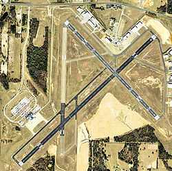
USGS 2006 orthophoto | |||||||||||||||||||
| IATA: TYR – ICAO: KTYR – FAA LID: TYR | |||||||||||||||||||
| Summary | |||||||||||||||||||
| Airport type | Public | ||||||||||||||||||
| Owner | City of Tyler | ||||||||||||||||||
| Serves | Tyler, Texas | ||||||||||||||||||
| Elevation AMSL | 544 ft / 166 m | ||||||||||||||||||
| Coordinates | 32°21′14″N 095°24′10″W / 32.35389°N 95.40278°WCoordinates: 32°21′14″N 095°24′10″W / 32.35389°N 95.40278°W | ||||||||||||||||||
| Website | www.cityoftyler.org/... | ||||||||||||||||||
| Map | |||||||||||||||||||
 TYR Location | |||||||||||||||||||
| Runways | |||||||||||||||||||
| |||||||||||||||||||
| Statistics (2011) | |||||||||||||||||||
| |||||||||||||||||||

Tyler Pounds Regional Airport (IATA: TYR, ICAO: KTYR, FAA LID: TYR) is a city-owned airport three miles west of Tyler, in Smith County, Texas.[1]
The National Plan of Integrated Airport Systems for 2011–2015 called it a primary commercial service airport.[2] Federal Aviation Administration records show 76,168 passenger boardings (enplanements) in calendar year 2008,[3] 73,841 in 2009 and 74,357 in 2010.[4]
The airport has been expanding to meet goals in "The Tyler Master Plan"; in August 17, 2002, the airport opened a new terminal building, doubling its space. Tyler is a large center for General Aviation, with three public parking lots for General Aviation arrivals.
The 2013 Federal sequester will result in the closure of the airport's control tower and will require pilots to rely on air traffic controllers from other area airports.[5][6]
History
- see: Pounds Army Airfield for its World War II use
The airport opened in November 1929 as Tyler Municipal Airport. During World War II the airfield was used by the United States Army Air Forces as a training base and renamed Pounds Field after Lieutenant Jack Windham Pounds. At the end of the war the airfield was turned over to local government for civil use and became Tyler Pounds Regional Airport. [7] [8] [9] [10]
Airline flights began in the 1930s; in 1952 Delta, Braniff and Trans-Texas stopped there, but in 1957 DL and BN were gone.
The Historic Aviation Memorial Museum (HAMM), a large aviation museum at the airport rented and moved into the old terminal that had been closed since 2002.
Facilities
The airport covers 1,200 acres (486 ha) at an elevation of 544 feet (166 m). It has three asphalt runways: 4/22 is 7,802 by 150 feet (2,378 x 46 m); 13/31 is 5,200 by 150 feet (1,585 x 46 m); 17/35 is 4,832 by 150 feet (1,473 x 46 m).[1]
In the year ending July 31, 2011 the airport had 48,677 aircraft operations, average 133 per day: 83% general aviation, 14% air taxi, 2% airline, and 1% military. 152 aircraft were then based at the airport: 60% single-engine, 22% jet, 16% multi-engine, and 2% helicopter.[1]
Airlines and destinations
Scheduled passenger service:
| Airlines | Destinations |
|---|---|
| American Eagle | Dallas/Fort Worth |
| United Express | Houston-Intercontinental |
Airlines
American Eagle and United Express fly respectively to Dallas/Fort Worth International Airport and George Bush Intercontinental Airport in Houston. As of fall 2008, American Eagle flies Embraer ERJ 145s to Dallas/Fort Worth while United Express continues to operate Saab 340B to Houston.
In early 2006, American Eagle announced it would be cutting flights to Tyler from eight per day to four per day.
On November 11, 2008 Tyler-Pounds Regional airport announced plans to add a fourth American Eagle regional jet departure from Tyler, starting January 6, 2009.
Continental Connection announced a daily flight to Tyler from Bush Intercontinental Airport to begin the same month as American Eagle planned to cut service from Dallas/Fort Worth.
References
- ↑ 1.0 1.1 1.2 1.3 FAA Airport Master Record for TYR (Form 5010 PDF). Federal Aviation Administration. Effective November 15, 2012.
- ↑ "2011–2015 NPIAS Report, Appendix A" (PDF, 2.03 MB). National Plan of Integrated Airport Systems. Federal Aviation Administration. October 4, 2010.
- ↑ "Enplanements for CY 2008" (PDF, 1.0 MB). CY 2008 Passenger Boarding and All-Cargo Data. Federal Aviation Administration. December 18, 2009.
- ↑ "Enplanements for CY 2010" (PDF, 189 KB). CY 2010 Passenger Boarding and All-Cargo Data. Federal Aviation Administration. October 4, 2011.
- ↑ "FAA Contract Tower Closure List". American Association of Airport Executives. March 22, 2013.
- ↑ "FAA: 149 control towers to close at small airports". USA Today. March 22, 2013.
- ↑
 This article incorporates public domain material from websites or documents of the Air Force Historical Research Agency.
 - ↑ Shaw, Frederick J. (2004), Locating Air Force Base Sites History’s Legacy, Air Force History and Museums Program, United States Air Force, Washington DC, 2004.
- ↑ Manning, Thomas A. (2005), History of Air Education and Training Command, 1942–2002. Office of History and Research, Headquarters, AETC, Randolph AFB, Texas ASIN: B000NYX3PC
- ↑ Thole, Lou (1999), Forgotten Fields of America : World War II Bases and Training, Then and Now - Vol. 2. Publisher: Pictorial Histories Pub, ISBN 1-57510-051-7
External links
| Wikimedia Commons has media related to Tyler Pounds Regional Airport. |
- Tyler Pounds Regional Airport at City of Tyler website
- Historic Aviation Memorial Museum, official website
- Tyler Pounds Regional (TYR) at Texas DOT airport directory
- Aerial image as of January 1996 from USGS The National Map
- FAA Airport Diagram (PDF), effective April 2, 2015
- FAA Terminal Procedures for TYR, effective April 2, 2015
- Resources for this airport:
- AirNav airport information for KTYR
- ASN accident history for TYR
- FlightAware airport information and live flight tracker
- NOAA/NWS latest weather observations
- SkyVector aeronautical chart for KTYR
- FAA current TYR delay information