Two Lights State Park
| Two Lights State Park | |
| Maine State Park | |
 Two Lights State Park | |
| Country | |
|---|---|
| State | |
| County | Cumberland |
| Town | Cape Elizabeth |
| Elevation | 66 ft (20 m) [1] |
| Coordinates | 43°33′38″N 70°12′21″W / 43.56056°N 70.20583°WCoordinates: 43°33′38″N 70°12′21″W / 43.56056°N 70.20583°W [1] |
| Area | 41 acres (17 ha) |
| Established | 1961 |
| Management | Maine Department of Agriculture, Conservation and Forestry |
| style=""color: #cde5b2"" | IUCN category | V - Protected Landscape/Seascape |
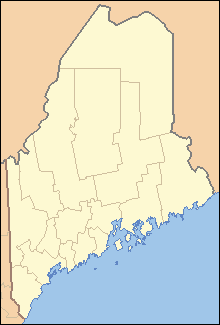 Location in Maine
| |
| Website: Two Lights State Park | |

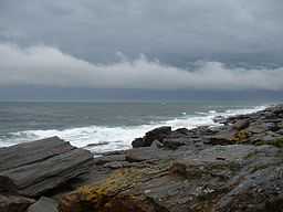
Two Lights State Park is a state park located on Cape Elizabeth, Maine, named after the twin Cape Elizabeth Lights.[2] The 41-acre (17 ha) park opened in 1961 and offers views of Casco Bay and the Atlantic Ocean. In addition to rocky headlands, the park includes the still-active easternmost Cape Elizabeth Light, the remains of a World War II-era seacoast battery bunker, and a fire control tower.
History
The park's twin lighthouses were built in 1828. One is still active, the other was decommissioned in 1924 and is now a private home. Edward Hopper made one of the towers the subject of his 1929 painting The Lighthouse at Two Lights.[3]
Facilities
Park facilities include paths and benches along the shore, rest rooms, and a playground. Picnic tables situated on the hills facing the ocean afford visitors views of the ocean.
References
- ↑ 1.0 1.1 "Two Lights State Park". Geographic Names Information System. United States Geological Survey.
- ↑ "Two Lights State Park". Department of Agriculture, Conservation and Forestry. Retrieved July 25, 2014.
- ↑ "The Lighthouse at Two Lights". The Collection Online. The Metropolitan Museum of Art. Retrieved July 25, 2014.
External links
- Two Lights State Park Department of Agriculture, Conservation and Forestry
| ||||||||||||||||||||||||||||||||||||||||||