Turtmann-Unterems
| Turtmann-Unterems | |
|---|---|
|
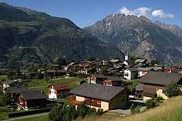
Unterems village in Turtmann-Unterems | |
 Turtmann-Unterems | |
|
Location of Turtmann-Unterems 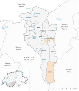 | |
| Coordinates: 46°17′N 7°42′E / 46.283°N 7.700°ECoordinates: 46°17′N 7°42′E / 46.283°N 7.700°E | |
| Country | Switzerland |
| Canton | Valais |
| District | Leuk |
| Government | |
| • Mayor | Johann Tscherrig |
| Area[1] | |
| • Total | 42.27 km2 (16.32 sq mi) |
| Elevation | 1,003 m (3,291 ft) |
| Highest elevation (Massoltern) | 1,200 m (3,900 ft) |
| Lowest elevation | 800 m (2,600 ft) |
| Population (Dec 2013[2]) | |
| • Total | 1,125 |
| • Density | 27/km2 (69/sq mi) |
| Postal code | 3948/3946 |
| SFOS number | 6119 |
| Surrounded by | Agarn, Ergisch, Oberems, Turtmann |
| Website |
www SFSO statistics |
Turtmann-Unterems is a municipality in the district of Leuk in the canton of Valais in Switzerland. The municipalities of Turtmann and Unterems merged on 1 January 2013 into the new municipality of Turtmann-Unterems.[3]
Geography
The former municipalities that make up Turtmann-Unterems had an area of 42.27 km2 (16.32 sq mi).[1]
Turtmann had an area, as of 2011, of 6.8 square kilometers (2.6 sq mi). Of this area, 46.2% is used for agricultural purposes, while 36.4% is forested. Of the rest of the land, 14.2% is settled (buildings or roads) and 3.2% is unproductive land.[4] It was located in the Leuk district, south of the Rhone river down in the Rhone valley at the entrance to the Turtmann valley. It consists of the village of Turtmann and the hamlets of Tännu and Ried.
Unterems had an area, as of 2011, of 1.4 square kilometers (0.54 sq mi). Of this area, 39.1% is used for agricultural purposes, while 53.6% is forested. Of the rest of the land, 7.2% is settled (buildings or roads) and 0.0% is unproductive land.[4] It was located in the Leuk district, high on the left side of the Rhone valley. It consists of the village of Unterems and the hamlets of Ze Schmidu, Feldishaus and Prupräsu.
Demographics
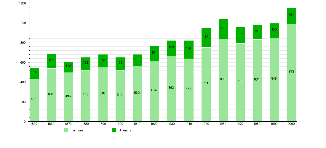
The total population of Turtmann-Unterems (as of December 2013) is 1,125.[2]
Historic Population
The historical population is given in the following chart:[5]
Sights
The entire village of Turtmann is designated as part of the Inventory of Swiss Heritage Sites[6]
References
- ↑ 1.0 1.1 Arealstatistik Standard - Gemeindedaten nach 4 Hauptbereichen
- ↑ 2.0 2.1 Swiss Federal Statistics Office – STAT-TAB Ständige und Nichtständige Wohnbevölkerung nach Region, Geschlecht, Nationalität und Alter (German) accessed 18 August 2014
- ↑ Amtliches Gemeindeverzeichnis der Schweiz published by the Swiss Federal Statistical Office (German) accessed 2 January 2013
- ↑ 4.0 4.1 Swiss Federal Statistical Office accessed 4 January 2013
- ↑ Federal Statistical Office STAT-TAB Bevölkerungsentwicklung nach Region, 1850-2000 (German) accessed 29 January 2011
- ↑ "Kantonsliste A-Objekte". KGS Inventar (in German). Federal Office of Civil Protection. 2009. Retrieved 25 April 2011.
External links
-

Wikimedia Commons has media related to Turtmann-Unterems.
| ||||||||