Turrialba Volcano
Turrialba Volcano is named after its canton, Turrialba, in Costa Rica's Cartago Province. There is no clear consensus on the origin of the name Turrialba, but historians disagree with attempts to attribute the name to the patronym Torrealba (from Aragon in Spain) or from the Latin Turris alba (white tower). The general consensus is that Turrialba derives from the local Indian (Huetar language), but there is no agreement on its actual roots.
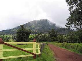
The stratovolcano is 3,340 m (10,958 ft) high and is about 45 minutes from the Atlantic slope town of Turrialba. The summit has three craters, one of which has fumaroles and sulfur pits. The largest of the craters has a diameter of 50 m (160 ft). [1] Visitors used to be able to hike down into the main crater, but increased gaseous activity has caused the time at the summit to be limited to no more than fifteen minutes. The hike to the top from where the vans usually are forced to stop takes about one to three hours depending on the ability of the hikers. Below the summit is a mountain range and montane forest, with ferns, bromeliads, lichens and mosses. Most of the forest is either primary or secondary forest.[2] The Turrialba Volcano National Park surrounds the area.
Turrialba is adjacent to Irazú and both are among Costa Rica's largest volcanoes. It had at least five large explosive eruptions in last 3500 years.
A viewing platform (Mirador) and path and steps were built overlooking the crater by volunteers from the charity Raleigh International in 2007. On clear days both the Pacific Ocean and Caribbean Sea can be seen.
Activity
- During the 19th century, the volcano erupted and emitted ash several times (1847, 1853, 1855, 1859, 1866), producing pyroclastic flows. The last major eruption was in 1866.[3]
- Small signs of activity starts in 1996.
- In January 2001, the volcano reported increased activity, displaying strong fumaroles at the central craters. The volcanic activities have increased since 2005.
- On March 31, 2007, the volcano started to show some activity with ash eruptions. [4]
- The National Park area opened for visitors was closed from 2009 to 2011.
- On January 8th, 2010, the volcano had a phreatic eruption, which created a new opening appeared near the crater on the southwest, and the temperature increased from 200 to 600 °C (392 to 1,112 °F). Two villages, La Central and El Retiro, were evacuated.[5]
- On January, 2012 a new opening on the west of the crater opened after a phreatic eruption.
- On April 12, 2012, a small eruption occurred.[6]
- On May 21, 2013, at 08:52, a gas explosion widened a couple of openings near the main crater that appeared in 2010 and 2012. [7]
- On July, 2013 researchers show that increased tremors around the area increased from about twenty earthquakes a day, to up to thirty per hour. [8]
- On October 17, 2014, the quantity of tremors increased from around 50-100 a day, to 200 a day. [9]
- On October 29, 2014, at around 10:10, a tremor started and kept constant, until a phreatic eruption from the west opening that appeared in January 2012, and starting at around 23:10, sent a lot of the material to areas up to 40 km (25 mi) away. Many citizens reported ash appearing on their properties and a strong sulphur odor in the cantons of Vásquez de Coronado, Goicoechea, Moravia, Desamparados, Aserrí, Escazú, Santa Ana, Montes de Oca, Tibás, Alajuelita, Puriscal, San José in the province of San José, La Union in the province of Cartago and Santo Domingo and Heredia, in the province of Heredia. [10]
March 2015
- On March 12, 2015, eruptions at around 11:00 and 14:12 sent ashes through all the Central Valley, it is regarded as the most significant activity since 1996. [11] The Juan Suantamaría and Tobías Bolaños international airports were closed due to visibility being less than 100 meters. [12]
- On March 13, 2015 an eruption occurred at 21:07.
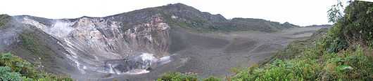
The three craters of the volcano, the oldest one is to right, the newest and most active is to the left.
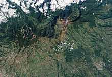
Turrialba emits a translucent plume of volcanic gases in this natural-colour satellite image.
See also
References
External links
 |
Wikimedia Commons has media related to Turrialba. |
Mountains of Costa Rica |
|---|
|
- Agua Gata
- Anunciación
- Arenal
- Azufrado
- Barva
- Cerro Barrera
- Bijagua
- Cerro Bola
- Braum
- Cerro Cacao
- Cacho Negro
- Caldera de Miravalles
- Cañas Dulces
- Cerro Cedral
- Cerro Buenos Aires
- Cerro de la Muerte
- Cerro de Las Vueltas
- Cerros de Escazú
- Chachaguita
- Chato
- Chirripó
- Chompipe
- Coco Mountain
- Cocorí Mountain
- Concepción Mountain
- Congo Mountain
- Coronel Mountain
- Coto Pelón
- Cotón
- Crestones (Costa Rica)
- Dikar
- Doussaints
- Duan Mountains
- Durika
- Echandi
- El Hacha
- El Jaboncillo
- Espiritu Santo Mountain
- Fortuna Mountain
- Gorgona Mountain
- Iglesias
- Irazú
- Juan Murillo Mountain
- Kámuk
- Laguna Bosque Alegre
- Laguna Poco Sol
- Laguna Rio IV
- Loma Barrantes
- Loma Morera
- Lomas
- Los Chiles
- Mano de Tigre
- Miravalles
- Monte de la Cruz
- Montezuma Mountain
- Morazán Mountain
- Negro
- Olla de Carne
- Orosi
- Palmira Mountain
- Pasquí
- Pata de Gallo
- Pelado y Delicias
- Pelón
- Perdidos
- Pico Alto (Costa Rica)
- Pico Blanco
- Piedra de Fuego
- Platanar
- Poás
- Porvenir Mountain
- Quemados
- Quezada Mountain
- Rabo de Mico
- Rincón (Costa Rica)
- Rincón de la Vieja
- San Miguel Mountain
- San Roque Mountain
- San Vicente Mountain
- Santa Maria Mountain
- Siete
- Sinsal
- Tenorio
- Tilarán
- Tortuguero Mountain
- Truncado
- Turrialba
- Urán
- Valle Hermoso Mountain
- Ventisqueros
- Viejo
- Von Francius
- Von Seebach
- Vuelta Kopper
- Weyl Mountain
| | |
|