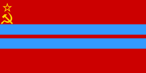
Turkmen Soviet Socialist Republic
| Turkmen Soviet Socialist Republic | ||||||
| Туркменская Советская Социалистическая Республика Түркменистан Совет Социалистик Республикасы Türkmenistan Sowet Sotsialistik Respublikasy | ||||||
| ||||||
| ||||||
| Anthem Anthem of Turkmen SSR | ||||||
 Location of the Turkmen SSR (red) within the Soviet Union. | ||||||
| Capital | Ashgabat | |||||
| Languages | Turkmen Russian | |||||
| Government | Soviet Socialist Republic | |||||
| History | ||||||
| - | Turkmen Oblast of the Turkestan ASSR | 7 August 1921 | ||||
| - | Turkmen SSR | 13 May 1925 | ||||
| - | Disestablished | 25 December 1991 | ||||
| Area | ||||||
| - | 1989 | 488,100 km² (188,456 sq mi) | ||||
| Population | ||||||
| - | 1989 est. | 3,522,700 | ||||
| Density | 7.2 /km² (18.7 /sq mi) | |||||
| Calling code | +7 360/363/370/378/432 | |||||
| Today part of | | |||||
Part of a series on the |
|---|
| History of Turkmenistan |
 |
|
The Turkmen Soviet Socialist Republic (Turkmen: Түркменистан Совет Социалистик Республикасы, Türkmenistan Sowet Sotsialistik Respublikasy; Russian: Туркменская Советская Социалистическая Республика, Turkmenskaya Sovetskaya Sotsialisticheskaya Respublika), also known as the Turkmen SSR, was one of republics of the Soviet Union in Central Asia. Initially, on 7 August 1921, it was established as the Turkmen Oblast of the Turkestan ASSR before being made, on 13 May 1925, a separate republic of the USSR as the Turkmen SSR. In 1991, it became independent and was renamed Turkmenistan.
History
Annexation to Russia
Russian attempts to encroach upon Turkmen territory began in earnest in the latter part of the nineteenth century. Of all the Central Asian peoples, the Turkmen put up the stiffest resistance against Russian expansion. In 1869 the Russian Empire established a foothold in present-day Turkmenistan with the foundation of the Caspian Sea port of Krasnovodsk (now Türkmenbaşy). From there and other points, they marched on and subdued the Khiva Khanate in 1873. Because Turkmen tribes, most notably the Yomud, were in the military service of the Khivan khan, Russian forces undertook punitive raids against Khorazm, in the process slaughtering hundreds of Turkmen and destroying their settlements. In 1881 the Russians under General Mikhail Skobelev besieged and captured Geok Tepe, one of the last Turkmen strongholds, northwest of Ashgabat. With the Turkmen defeat (which is now marked by the Turkmen as a national day of mourning and a symbol of national pride), the annexation of what is present-day Turkmenistan met with only weak resistance. Later the same year, the Russians signed an agreement with the Persians and established what essentially remains the current border between Turkmenistan and Iran. In 1897 a similar agreement was signed between the Russians and Afghans.[1]
Following annexation to Russia, the area was administered as the Transcaspian Region by corrupt and malfeasant military officers and officials appointed by the Turkestan Governor-Generalship in Tashkent. In the 1880s, a railroad was built from Krasnovodsk to Ashgabat and later extended to Tashkent. Urban areas began to develop along the railway. Although the Transcaspian Region essentially was a colony of Russia, it remained a backwater, except for Russian concerns with British colonialist intentions in the region and with possible uprisings by the Turkmen.[1]
Creation of SSR
Because the Turkmen generally were indifferent to the advent of Soviet rule in 1917, little revolutionary activity occurred in the region in the years that followed. However, the years immediately preceding the revolution had been marked by sporadic Turkmen uprisings against Russian rule, most prominently the anti-tsarist revolt of 1916 that swept through the whole of Turkestan. Their armed resistance to Soviet rule was part of the larger Basmachi Revolt throughout Central Asia from the 1920s into the early 1930s, which included most of the future USSR dependencies. Although Soviet sources describe this struggle as a minor chapter in the republic's history, it is clear that opposition was fierce and resulted in the death of large numbers of Turkmen.[2]
In October 1924, when Central Asia was divided into distinct political entities, the Transcaspian Region and Turkmen Oblast of the Turkestan Autonomous Soviet Socialist Republic (Turkestan ASSR) became the Turkmen Soviet Socialist Republic (Turkmen SSR), a full-fledged constituent republic of the Soviet Union. During the forced collectivization and other extreme socioeconomic changes of the first decades of Soviet rule, pastoral nomadism ceased to be an economic alternative in Turkmenistan, and by the late 1930s the majority of Turkmen had become sedentary. Efforts by the Soviet state to undermine the traditional Turkmen way of life resulted in significant changes in familial and political relationships, religious and cultural observances, and intellectual developments. Significant numbers of Russians and other Slavs, as well as groups from various nationalities mainly from the Caucasus, migrated to urban areas. Modest industrial capabilities were developed, and limited exploitation of Turkmenistan's natural resources was initiated.[2]
Under Soviet rule, all religious beliefs were attacked by the communist authorities as superstition and "vestiges of the past." Most religious schooling and religious observance were banned, and the vast majority of mosques were closed. An official Muslim Board of Central Asia with a headquarters in Tashkent was established during World War II to supervise the Islam faith in Central Asia. For the most part, the Muslim Board functioned as an instrument of propaganda whose activities did little to enhance the Muslim cause. Atheist indoctrination stifled religious development and contributed to the isolation of the Turkmen from the international Muslim community. Some religious customs, such as Muslim burial and male circumcision, continued to be practiced throughout the Soviet period, but most religious belief, knowledge, and customs were preserved only in rural areas in "folk form" as a kind of unofficial Islam not sanctioned by the state-run Spiritual Directorate.[3]
Pre-independence
Beginning in the 1930s, Moscow kept the republic under firm control. The nationalities policy of the Communist Party of the Soviet Union (CPSU) fostered the development of a Turkmen political elite and promoted Russification. Slavs, both in Moscow and Turkmenistan, closely supervised the national cadre of government officials and bureaucrats; generally, the Turkmen leadership staunchly supported Soviet policies. Moscow initiated nearly all political activity in the republic, and, except for a corruption scandal in the mid-1980s that ousted longtime General Secretary Muhammetnazar Gapurow, Turkmenistan remained a quiet Soviet republic. Mikhail S. Gorbachev's policies of glasnost and perestroika did not have a significant impact on Turkmenistan, as many people there were self-dependent, and settlers of the territory and the Soviet Union's ministers rarely intertwined. The republic found itself rather unprepared for the dissolution of the Soviet Union and the independence that followed in 1991.[4]
When other constituent republics of the Soviet Union advanced claims to sovereignty in 1988 and 1989, Turkmenistan's leadership also began to criticize Moscow's economic and political policies as exploitative and detrimental to the well-being and pride of the Turkmen. By a unanimous vote of its Supreme Soviet, Turkmenistan declared its sovereignty in August 1990. After the August 1991 coup attempt against the Gorbachev regime in Moscow, Turkmenistan's communist leader Saparmurat Niyazov called for a popular referendum on independence. The official result of the referendum was 94 percent in favor of independence. The republic's Supreme Soviet had little choice other than to declare Turkmenistan's independence from the Soviet Union and the establishment of the Republic of Turkmenistan on October 27, 1991.[4] Turkimenstan received independence from the Soviet Union on December 25, 1991.
Geography
Coasts
The Caspian coast of Turkmenistan is weakly indented in the south. In the north it is strongly indented, forming the Kara-Bogaz-Gol, Krasnovodsk, and Turkmen gulfs, the Krasnovodsk, Dardzha, and Cheleken peninsulas, and numerous spits, of which the largest is the Krasnovodsk. The shores are low and sandy. Coastal islands include Ogurchinskii and Kamyshlyada.
Topography. The Kopetdag mountain system extends through the southern part of the republic, rising to 2,942 m at Mount Rize; northwest of the Kopetdag are the two separate ranges of the Malyi Balkhan (elevations to 777 m) and Bol’shoi Balkhan (elevations to 1,881 m). North of the Kopetdag lies a submontane plain that merges into the plain of the Caspian Lowland to the west. The northern foothills of the Paropamisus extend into Turkmenistan in the southeast, represented by the highlands of Badkhyz (maximum elevation 1,267 m) and Karabil’ (maximum elevation 984 m) and separated by the Murgab River. In the extreme southeast the Kugitangtau Mountains, a spur of the Gissar Mountains, rise to an elevation of 3,139 m, the highest point in the republic.
The Krasnovodsk Plateau, with a maximum elevation of 308 m, is located in the west, and the southern edge of the Ustiurt Plateau is located in the northwest. To the south of the Ustiurt Plateau is the Zauzboi, a folded region consisting of a system of cuesta tablelands, including Kaplankyr and Cheliunkry, and separated by depressions. The uplands of Nebitdag (39 m), Boiadag (134 m), Kumdag, and Mondzhukly (27 m) rise from the plain of the Caspian Lowland. Extending north and northeast from the submontane plain of the Kopetdag is the Karakum Desert, which divides into the central, or Lowland, Karakum and the Transun-guz Karakum. The southeastern Karakum is located in the interfluvial region of the Amu Darya and Tedzhen rivers. These deserts are characterized by honeycombed sand ridges and semi-overgrown sand hummocks; there are areas of barchan sands and, in the depressions, takyrs and sory. The Sundukli sands—a narrow strip of the right bank of the Amu Darya—lie within Turkmenistan.
Geological structure and minerals
Turkmenistan lies within the Mediterranean geosynclinal belt and occupies part of two large tectonic components—the epi-Paleozoic Turan Platform and an Alpine folded region. The Turan Platform includes a pre-Upper Paleozoic metamorphic basement, an Upper Paleozoic-Triassic effusive-sedimentary complex, and a Mesozoic-Cenozoic cratonic mantle.
The Alpine folded region is made up of the West Turkmen Basin in the west, which forms the eastern edge of the isometric South Caspian Intermontane Basin, and the sublatitudinal folded upwarping of the Kopetdag in the east. The two are bounded on the north by the South Turkmen marginal line, which extends in a northwesterly direction.
The Cis-Kopetdag Depression is located between the Kopetdag mountain system and the Turan Platform. The pre-Alpine basement is composed of pre-Upper Paleozoic metamorphic formations and effusive-sedimentary formations of the Upper Paleozoic (?) to Triassic. The complex above is up to 8 km thick and is composed of sedimentary geosynclinal, geoanticlinal, and sub-platform formations of the Mesozoic to the Paleogene; in the north these pass into platform and orogenic formations of the Upper Oligocene to Anthropogene (several km thick), which fill the West Turkmen Basin and the Cis-Kopetdag Depression.
Eastern Turkmenistan, including the mountainous block-fold uplift of the southwestern spurs of the Gissar Mountains, belongs to an epiplatform region composed of a Paleozoic basement and a Mesozoic-Cenozoic sedimentary mantle. The lower layers of the mantle consist of platform formations of the Jurassic to the Paleogene, and the upper layers consist of orogenic formations of the Neogene to the Anthropogene. The southern regions of Turkmenistan are characterized by high seismic activity.
The most important mineral resources are petroleum and natural gas. The principal oilfields, such as the Leninskoe at Kotur-depe and the Barsa-Gel’mes, are associated with the Pliocene deposits of the West Turkmen Basin. The most important gas deposits, such as Shatlyk, Achak, and Naip, are associated with the Mesozoic sediments of the eastern platform region. Turkmenistan occupies second place in the USSR (after the RSFSR) in known gas reserves. A number of small coal deposits have been discovered in Jurassic sediments.
Turkmenistan is rich in deposits of mineral salts, including calcium chloride and other chlorides, and sulfates, such as anhydrite, gypsum, and mirabilite. The principal salt deposits are associated with the Jurassic saliferous formation of eastern Turkmenistan, where the largest deposits are the Gaurdak and Karliuk, and with the newer deposits of the Kara-Bogaz-Gol. There are also mercury deposits in the Kopetdag. Nonmetallic mineral resources include sulfur, bentonite, ozocerite, and building materials (raw materials for glass and cement).
Underground waters are also precious resources. They include drinking water, water for industrial use, waters bearing iodine and bromine, and medicinal mineral waters. New sources of fresh water have been discovered at depths of 50–250 m in the Karakum. In the takyrs methods are being developed to collect rainwater in artificial reservoirs called khaki.
Climate
The climate is distinctly continental and dry, with wide annual and diurnal temperature ranges, low humidity, high evaporation, and scant precipitation. Summers are hot and dry, the winters mild and sometimes cold with little snow; short humid springs and dry autumns are typical. The average January temperature ranges from -5°C in the northeast to 4°C near the Atrek River; the absolute minimum is –32°C in Tashauz Oblast, -29°C in the submontane zone of the Kopetdag, and –10.3°C along the southern coast of the Caspian. Average July temperatures range from 28°C in the northeast to 32°C in the south; the absolute maximum is 49.9°C at the Repetek station.
Precipitation ranges from 80 mm per year in the lower reaches of the Amu Darya to 150 mm in the Karakum Desert, 200–300 mm in the foothills and mountain valleys, and 400 mm and more in the mountains, with a maximum in the spring and winter. The snow cover is variable and usually lasts only a few days in the northern and mountain regions. Winds are constant, with northeasterly, northerly, and northwesterly winds predominating. A hot dry wind known as the garmsil’ blows through the foothills of the Kopetdag in summer, and dust storms occur during changes of season. The growing season lasts 200 to 270 days.
Rivers and lakes
Up to 80 percent of Turkmenistan lacks any permanent surface waters. The rivers lie only in the peripheral southern and eastern regions. The only large river is the Amu Darya, which flows through the eastern border region. The Amu Darya has two high-water periods: the lesser one occurs in spring and is caused by rains and the melting of snow in low mountain regions; the chief high water occurs in summer and is due to the melting of glaciers and snow in high mountain regions. The river carries a great quantity of suspended matter, which increases the fertility of the lands it irrigates. The V. I. Lenin Karakum Canal has brought the waters of the Amu Darya as far as Bakharden —900 km (1975).[5]
See also
- Communist Party of the Turkmen SSR
Notes
- ↑ 1.0 1.1 Curtis (1996). "Turkmenistan: Incorporation into Russia".
- ↑ 2.0 2.1 Curtis (1996). "Turkmenistan: Soviet Turkmenistan".
- ↑ Curtis (1996). "Turkmenistan: History and Structure".
- ↑ 4.0 4.1 Curtis (1996). "Turkmenistan: Sovereignty and Independence".
- ↑ "Turkmen Soviet Socialist Republic". The Great Soviet Encyclopedia.
References
![]() This article incorporates public domain material from websites or documents of the Library of Congress Country Studies.
This article incorporates public domain material from websites or documents of the Library of Congress Country Studies.
- Curtis, Glenn E. (1996). Turkmenistan: A Country Study. Library of Congress Country Studies. Washington: United States Government Printing Office. OCLC 45380435.
External links
| |||||||||||||||||||||||||
