Tuqtupampa
| Tuqtupampa | |
|---|---|
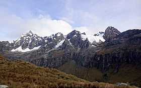 Tuqtupampa as seen from below Punta Unión | |
| Elevation | 5,420 m (17,780 ft)[1] |
| Location | |
 Tuqtupampa Peru | |
| Location | Peru, Ancash Region |
| Range | Andes, Cordillera Blanca |
| Coordinates | 8°54′12″S 77°33′30″W / 8.90333°S 77.55833°WCoordinates: 8°54′12″S 77°33′30″W / 8.90333°S 77.55833°W |
Tuqtupampa (Quechua tuqtu broody hen, pampa a large plain,[2] "broody hen plain", also spelled Tuctubamba, Tuqtubamba) is a 5,420-metre (17,782 ft) high mountain in the Cordillera Blanca in the Andes of Peru.[3] It is situated in the Ancash Region, at the border of the Mariscal Luzuriaga Province, Lucma District, the Pomabamba Province, Huayllán District, and the Yungay Province, Yanama District. Tuqtupampa lies southeast of the mountain Tawllirahu.[4][5]
See also
References
- ↑ John F. Ricker, Yuraq Janka: A Guide to the Peruvian Andes
- ↑ Teofilo Laime Ajacopa, Diccionario Bilingüe Iskay simipi yuyayk'ancha, La Paz, 2007 (Quechua-Spanish dictionary)
- ↑ www.andix.com Map of a part of the Cordillera Blanca
- ↑ escale.minedu.gob.pe - UGEL map of the Huaylas Province 2 (Ancash Region)
- ↑ "Andes. Perú. Cordillera Blanca. Errores u omisiones. El Taulliraju Sur confundido con el Tuctubamba. Parte I". Andes Info. Retrieved January 29, 2015.