Tuqllarahu
| Tuqllarahu | |
|---|---|
 | |
| Elevation | 6,034 m (19,797 ft)[1] |
| Location | |
 Tuqllarahu Peru | |
| Location | Peru, Ancash Region |
| Range | Andes, Cordillera Blanca |
| Coordinates | 9°20′50″S 77°23′49″W / 9.34722°S 77.39694°WCoordinates: 9°20′50″S 77°23′49″W / 9.34722°S 77.39694°W |
| Climbing | |
| First ascent | 31 July 1939 by W. Brecht and H. Schweizer[2] |
| Easiest route | Northwest ridge |
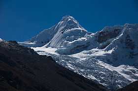
Tuqllarahu (Quechua tuqlla trap,[3] rahu snow, ice, mountain with snow,[4] "snow covered trap mountain", hispanicized spelling Tocllaraju) is a mountain in the Cordillera Blanca in the Andes of Peru,[5] about 6,034 m (19,797 ft) high. It is situated in the Ancash Region, Carhuaz Province, Aco District, and in the Huaraz Province, Tarica District.[6] Tuqllarahu lies north-west of the mountains Pukaranra and Pallqarahu.
Climbing
The easiest routes to the summit of this mountain are the northeast and the north ridges. The northeast ridge is rated PD+/AD- and it was the route followed when the mountain was summited the first time by W. Brecht and H. Schweizer on 31 July 1939. The north ridge route is also rated PD+/AD- and depending on the condition of the bergschrund is the easiest alternative to the normal route.
An harder alternative is the west face, rated D. The route develops mainly on a 55° ice slope with a section of 150 m (500 ft) and consists of 10 pitches. The descend is usually done by the northwest ridge.
References
- ↑ allthemountains.com/httpdocs/palcaraju.htm. Map of a part of the Cordillera Real (inactive website)
- ↑ andeshandbook.org
- ↑ Teofilo Laime Ajacopa, Diccionario Bilingüe Iskay simipi yuyayk'ancha, La Paz, 2007 (Quechua-Spanish dictionary)
- ↑ babylon.com
- ↑ www.andix.com Map of the Cordillera Blanca
- ↑ escale.minedu.gob.pe - UGEL map of the Huaraz Province (Ancash Region) (unnamed)
External links
| Wikimedia Commons has media related to Tuqllarahu. |