Tuntange
| Tuntange Tënten | ||
|---|---|---|
| Commune | ||
|
Tuntange church and its remarkable platanus | ||
| ||
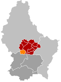 Map of Luxembourg with Tuntange highlighted in orange, the district in dark grey, and the canton in dark red | ||
| Country |
| |
| District | Luxembourg | |
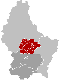
| Canton | Mersch | |
| Government | ||
| • Mayor | Christiane Eicher-Karier | |
| Area | ||
| • Total | 18.74 km2 (7.24 sq mi) | |
| Area rank | 63rd of 105 | |
| Highest elevation | 383 m (1,257 ft) | |
| • Rank | 68th of 105 | |
| Lowest elevation | 230 m (750 ft) | |
| • Rank | 43rd of 105 | |
| Population (2014) | ||
| • Total | 1,459 | |
| • Rank | 86th of 105 | |
| • Density | 78/km2 (200/sq mi) | |
| • Density rank | 71st of 105 | |
| Time zone | CET (UTC+1) | |
| • Summer (DST) | CEST (UTC+2) | |
| LAU 2 | LU00012011 | |
| Website | tuntange.net | |

Tuntange (Luxembourgish: Téinten, German: Tüntingen) is a commune and small town in western Luxembourg, in the canton of Mersch.
As of 2005, the town of Tuntange, which lies in the west of the commune, has a population of 580. Other towns within the commune include Ansembourg, Bour, Hollenfels and Marienthal.
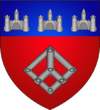
Coat of Arms
The arms were granted on January 25, 1983.
The field with its single charge, a buckle, is derived from the arms of the Lords of Hollenfels, as the village was part of the Hollenfels Estate. The chief symbolizes the three castles in the municipality; the Hollenfels Castle and the Old Castle of Ansembourg and New Castle of Ansembourg.
External links
| Wikimedia Commons has media related to Tuntange. |
| ||||||||