Tung Lung Chau
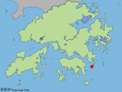


Tung Lung Chau (Chinese: 東龍洲, lit. eastern dragon island), also known as Nam Tong Island (南堂島) is an island located off the tip of the Clear Water Bay Peninsula in the New Territories of Hong Kong. It is also referred by Hong Kong people as Tung Lung To or Tung Lung Island (東龍島). The island is largely uninhabited. Administratively, it belongs to Sai Kung District.
Geography
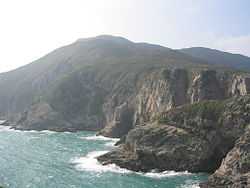
The island has an area of 2.42 km².[1] It forms one of the boundaries of Tathong Channel, which leads into Victoria Harbour through Lei Yue Mun. The northern tip of Tung Lung Chau is separated from the southern tip of Clear Water Bay Peninsula by the narrow Fat Tong Mun Channel.
Sights
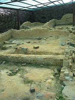
Tung Lung Chau is the site of Tung Lung Fort, which was constructed 300 years ago and recently refurbished. A prehistoric stone carving can also be found on the island. Measuring 180 cm by 240 cm, it is the largest ancient rock carving in Hong Kong.[2] Both the fort and the stone carving are declared monuments of Hong Kong.
Tung Lung Fort Special Area was designated as a Special Area under country parks in 1979 and covers 3 hectares. The area contains the fort and a campsite.[3][4]
Rock climbing
Tung Lung houses some of the best sport climbing venues in Hong Kong.[5]
Transportation
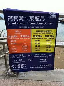
On weekends, kai-to service is available from Sam Ka Tsuen, near Lei Yue Mun (Kowloon side) and is operated by Coral Sea Ferry. The round-trip fare is HK$45 as of January 2015.
There was previously a service from Sai Wan Ho operated by Lam Kee Ferry (林記街渡). The last day of service was 26 January 2014.[6]
The ferry service from Sai Wan Ho to Tung Lung Chau was reinstated on October 1st 2014 and is run by a new operator. The round-trip fare is HK$55 for adults and HK$40 for children aged 3 and above.
See also
| Wikimedia Commons has media related to Tung Lung Chau. |
- Islands of Hong Kong
- March of Tung Lung To
References
| ||||||||||
| ||||||||||||||||||||||||||||
Coordinates: 22°14′57″N 114°17′23″E / 22.24917°N 114.28972°E