Tugford

Coordinates: 52°28′48″N 2°39′18″W / 52.48°N 2.655°W
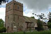
St Catherine's church
Tugford is a hamlet in Shropshire, England. It lies in the civil parish of Abdon, between Bouldon and Holdgate, on the boundary of the relatively flat Corvedale and the upland Clee Hills.[1]
The church of St Catherine dates from the 12th century and is a Grade II* listed building.[2] It features two sheela na gig statues.[3]
References
- ↑ Ordnance Survey mapping
- ↑ "Name: CHURCH OF ST CATHERINE List entry Number: 1383393". English Heritage. Retrieved 20 October 2014.
- ↑ Sheela na gig website: Tugford sheelas
| ||||||||||||||||||||||