Tsurugashima, Saitama
| Tsurugashima 鶴ヶ島市 | ||
|---|---|---|
| City | ||
| ||
|
Location of Tsurugashima in Saitama Prefecture | ||
 Tsurugashima Location in Japan | ||
| Coordinates: 35°56′N 139°33′E / 35.933°N 139.550°ECoordinates: 35°56′N 139°33′E / 35.933°N 139.550°E | ||
| Country | Japan | |
| Region | Kantō | |
| Prefecture | Saitama Prefecture | |
| Government | ||
| • Mayor | Yoshirō Fujinawa (since November 2005) | |
| Area | ||
| • Total | 17.73 km2 (6.85 sq mi) | |
| Population (February 1, 2012) | ||
| • Total | 69,974 | |
| • Density | 3,900/km2 (10,000/sq mi) | |
| Time zone | Japan Standard Time (UTC+9) | |
| Area code(s) | 049 | |
| Symbols | ||
| - Tree | Pine | |
| - Flower | Azalea | |
| Address |
16-1 Mitsugi, Tsurugashima-shi, Saitama-ken 350-2292 | |
| Phone number | 049-271-1111 | |
| Website |
www | |
Tsurugashima (鶴ヶ島市 Tsurugashima-shi) is a city located in Saitama Prefecture, Japan.
As of February 1, 2012, the city has an estimated population of 69,974, with 28,581 households. The total area is 17.73 km².
The modern city of Tsurugashima was founded when the former town of Tsurugashima was elevated to city status on September 1, 1991.
Adjoining cities and towns
Transportation
Rail
The city is served by Tsurugashima Station on the Tōbu Tōjō Line and also Ippommatsu Station on the Tōbu Ogose Line. Wakaba Station on the Tōbu Tōjō Line lies on the city boundary between Tsurugashima and Sakado. Tsurugashima Station is approximately 40 minutes from Ikebukuro Station in Tokyo on the Tōbu Tōjō Line by direct express train.
Bus
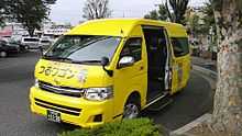
- Tsuru Bus community bus service
- Tsuru Wagon community minibus service
Culture
- Zennōji Temple
Shopping

- Wakaba Walk Shopping Centre
Notable people
- Aria Jasuru Hasegawa, footballer[1]
- Jin Katagiri, comedian and member of the Rahmens duo[1]
- Ryuji Kawai, footballer[1]
- Atsuko Sakurai, actress[1]
- Hideaki Takeda, footballer[1]
- Jun Uruno, footballer[1]
References
External links
![]() Media related to Tsurugashima, Saitama at Wikimedia Commons
Media related to Tsurugashima, Saitama at Wikimedia Commons
- Tsurugashima City official website (Japanese)
| |||||||||||||||||||||||||