Tsovak
| Tsovak Ծովակ | |
|---|---|
 Tsovak | |
| Coordinates: 40°10′58″N 45°38′02″E / 40.18278°N 45.63389°ECoordinates: 40°10′58″N 45°38′02″E / 40.18278°N 45.63389°E | |
| Country | Armenia |
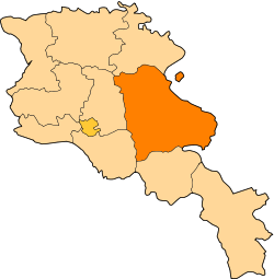
| Marz (Province) | Gegharkunik |
| Elevation | 1,920 m (6,300 ft) |
| Population (2008) | |
| • Total | 2,749 |
| Time zone | GMT+4 (UTC+4) |
| Postal code | 1612 |
Tsovak (Armenian: Ծովակ; formerly, Nerkin Zagalu and Nizhniy Zagalu) is a village in the Gegharkunik Province of Armenia. The village is the site of a large Iron Age fort atop the hill to the south and west, with an 8th century BCE cuneiform inscription of Sarduri II cut into the stone at the north edge of the fortification.[1]
References
- Tsovak at GEOnet Names Server
- World Gazeteer: Armenia – World-Gazetteer.com
- Report of the results of the 2001 Armenian Census, National Statistical Service of the Republic of Armenia
- Brady Kiesling, Rediscovering Armenia, p. 47; original archived at Archive.org, and current version online on Armeniapedia.org.