Tschiertschen-Praden
| Tschiertschen-Praden | |
|---|---|
|
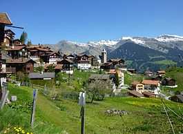
Tschiertschen village | |
 Tschiertschen-Praden | |
|
Location of Tschiertschen-Praden 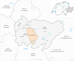 | |
| Coordinates: 46°49′N 9°36′E / 46.817°N 9.600°ECoordinates: 46°49′N 9°36′E / 46.817°N 9.600°E | |
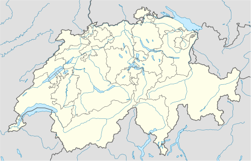
| Country | Switzerland |
| Canton | Graubünden |
| District | Plessur |
| Government | |
| • Executive | Gemeinderat |
| • Mayor | Gemeindepräsident |
| Area[1] | |
| • Total | 27.75 km2 (10.71 sq mi) |
| Elevation | 1,350 m (4,430 ft) |
| Population (Dec 2013[2]) | |
| • Total | 310 |
| • Density | 11/km2 (29/sq mi) |
| Postal code | 7063, 7063 |
| SFOS number | 3932 |
| Localities | Praden, Tschiertschen |
| Surrounded by | Calfreisen, Castiel, Churwalden, Maladers, Arosa, Lüen, Molinis, Parpan, Vaz/Obervaz |
| Website |
www SFSO statistics |
Tschiertschen-Praden is a municipality in the district of Plessur in the Grisons, Switzerland. It was formed on 1 January 2009 through the merger of Praden and Tschiertschen.[3]
Geography
Tschiertschen has a combined area, as of 2006, of 27.8 km2 (10.7 sq mi).[4]
The municipality is located in the Churwalden sub-district of the Plessur district on the mountain slopes above the left side of the Schanfigger valley. It consists of the haufendorf village (an irregular, unplanned and quite closely packed village, built around a central square) of Tschiertschen at an elevation of 1,351 m (4,432 ft) and the linear villages of Inner- and Usserpraden at an elevation of 1,100 m (3,600 ft) and 1,250 m (4,100 ft) respectively.
Demographics
Tschiertschen-Praden has a population (as of 31 December 2013) of 310.[2]
The combined historical population is given in the following table:[5][6]
| year | population |
|---|---|
| 1803 | 280 |
| 1850 | 268 |
| 1900 | 270 |
| 1950 | 272 |
| 2000 | 326 |
Weather
Tschiertschen has an average of 123.9 days of rain per year and on average receives 1,095 mm (43.1 in) of precipitation. The wettest month is August during which time Tschiertschen receives an average of 140 mm (5.5 in) of precipitation. During this month there is precipitation for an average of 12.7 days. The month with the most days of precipitation is June, with an average of 13.1, but with only 128 mm (5.0 in) of precipitation. The driest month of the year is February with an average of 61 mm (2.4 in) of precipitation over 12.7 days.[7]
References
- ↑ Arealstatistik Standard - Gemeindedaten nach 4 Hauptbereichen
- ↑ 2.0 2.1 Swiss Federal Statistics Office – STAT-TAB Ständige und Nichtständige Wohnbevölkerung nach Region, Geschlecht, Nationalität und Alter (German) accessed 18 August 2014
- ↑ Amtliches Gemeindeverzeichnis der Schweiz published by the Swiss Federal Statistical Office (German) accessed 23 September 2009
- ↑ Swiss Federal Statistical Office accessed 27-Oct-2009
- ↑ Praden in German, French and Italian in the online Historical Dictionary of Switzerland.
- ↑ Tschiertschen in German, French and Italian in the online Historical Dictionary of Switzerland.
- ↑ "Temperature and Precipitation Average Values-Table, 1961-1990" (in German, French, Italian). Federal Office of Meteorology and Climatology - MeteoSwiss. Retrieved 8 May 2009. , the weather station elevation is 1375 meters above sea level.
External links
| Wikimedia Commons has media related to Tschiertschen-Praden. |
- Adolf Collenberg: Tschiertschen-Praden in Romansh in the online Lexicon Istoric Retic.
- Praden in Romansh, German, French and Italian in the online Historical Dictionary of Switzerland.
- Tschiertschen in German, French and Italian in the online Historical Dictionary of Switzerland.
| ||||||||