Truxton Circle
| Truxton Circle | |
|---|---|
| Neighborhood of Washington, D.C. | |
|
Winter street scene in Truxton Circle | |
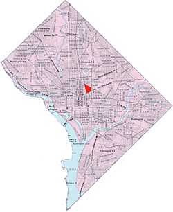
 Truxton Circle within the District of Columbia | |
| Coordinates: 38°54′40″N 77°00′32″W / 38.911056°N 77.008972°WCoordinates: 38°54′40″N 77°00′32″W / 38.911056°N 77.008972°W | |
| Country | United States |
| District | Washington, D.C. |
| Ward | Ward 5 |
| Government | |
| • Councilmember | Kenyan McDuffie |
Truxton Circle is a neighborhood of Northwest Washington, D.C., bordered by New Jersey Avenue to the west, Florida Avenue to the north, New York Avenue to the South, and North Capitol Street to the East. Politically, it is partially in Ward 5. It is bordered on the north by Bloomingdale and LeDroit Park, to the east by Eckington, to the west by Shaw and Mt. Vernon Square Historic District and the south by the NOMA developmental zone. Named for a traffic circle that was demolished in 1947, the neighborhood is reclaiming its identity after decades of being presumed nameless.
The old traffic circle was constructed about 1900 at the intersection of Florida Avenue and North Capitol Street, centered on a large and ornate fountain built as a monument to Navy Commodore Thomas Truxtun. The circle, which saw more than its share of traffic jams and accidents, was demolished in 1947. As the circle slipped into history, so did the identity of the predominantly African American neighborhood. It was sometimes lumped in with Shaw, or mistaken for Eckington to the north, or called by the dubious name of "Florida Park," but most residents considered it nameless.
Truxton Circle contains late 19th-century houses and historical schools, including Armstrong Manual Training School (where Duke Ellington received his high school diploma) and the original Dunbar High School, the first all-black public high school in the United States. Along with Armstrong, the former John Mercer Langston School, John Fox Slater Elementary School and the Margaret Murray Washington School buildings are all listed on the National Register of Historic Places. The neighborhood is currently home to several parks and playgrounds, such as Truxton Park, which lies at the corner of First Street and Florida Avenue, New York Avenue Playground at the corner of First Street and N Street, and Bundy Playground in between O Street and P Street.
Political boundaries and civic associations
A majority of Truxton Circle resides within Ward 5, with the south east corner bounded by Kirby St and N St residing in Ward 6. After the 2012 redistricting, the Ward 5 portions moved from ANC-5C to ANC-5E and is now served by two Single Member Discricts 5E05 (south of Q St) and 5E06 (north of Q St and shared with Bloomingdale).[1]
Truxton Circle is home to two Civic Associations, the Bates Ares Civic Association which covers the portion north of P St NW and the Hanover Civic Association which covers the portions between New Jersey and North Capitol NW and south of O St NW.
Notes
- ↑ "ANC 5E Map". Retrieved 31 December 2012.
| Wikimedia Commons has media related to Truxton Circle, Washington, D.C.. |
External links
- Truxton Circle Genealogy Website
- Bates Area Civic Association
- Hanover Area Civic Association
- Why Is It Named Truxton Circle? And, Where's the Circle?
- Washington Post 'http://www.washingtonpost.com/realestate/2011/05/13/AGjO6mCH_story.html'
.jpg)