Trouy
| Trouy | ||
|---|---|---|
|
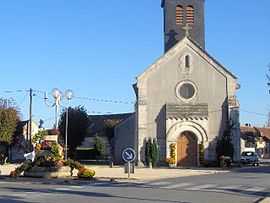
The church in Trouy | ||
| ||
 Trouy | ||
|
Location within Centre region  Trouy | ||
| Coordinates: 47°00′40″N 2°21′30″E / 47.0111°N 2.3583°ECoordinates: 47°00′40″N 2°21′30″E / 47.0111°N 2.3583°E | ||
| Country | France | |
| Region | Centre-Val de Loire | |
| Department | Cher | |
| Arrondissement | Bourges | |
| Canton | Levet | |
| Intercommunality | Bourges Plus | |
| Government | ||
| • Mayor (2008–2014) | Valentin Ducrocq | |
| Area1 | 23.19 km2 (8.95 sq mi) | |
| Population (2008)2 | 3,836 | |
| • Density | 170/km2 (430/sq mi) | |
| INSEE/Postal code | 18267 / 18570 | |
| Elevation | 133–174 m (436–571 ft) | |
|
1 French Land Register data, which excludes lakes, ponds, glaciers > 1 km² (0.386 sq mi or 247 acres) and river estuaries. 2 Population without double counting: residents of multiple communes (e.g., students and military personnel) only counted once. | ||
.svg.png)
Trouy is a commune in the Cher department in the Centre region of France.
Geography
An area of farming and a little light industry, comprising the village, several hamlets and a suburb situated just 4 miles (6.4 km) south of Bourges city centre, at the junction of the D31, D73 and the D107 roads. The A71 autoroute passes through the commune along with the N144 and N142 roads.
Population
| Historical population | ||
|---|---|---|
| Year | Pop. | ±% |
| 1962 | 697 | — |
| 1968 | 785 | +12.6% |
| 1975 | 2,132 | +171.6% |
| 1982 | 2,845 | +33.4% |
| 1990 | 2,877 | +1.1% |
| 1999 | 2,980 | +3.6% |
| 2008 | 3,836 | +28.7% |
Sights
- The church of St. Pierre, dating from the twelfth century.
-

The mairie
-
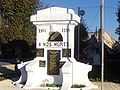
The war memorial
-
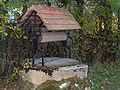
The well, on the rue du Mai
-
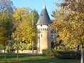
The chateau
See also
References
External links
| Wikimedia Commons has media related to Trouy. |
- Official Trouy website (French)
- Départemental Tourisme Office (French)
- Trouy on the Quid website (French)