Tropolje
| Tropolje (Završje) | |
|---|---|
| Historical regiona | |
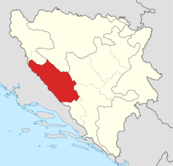 Approximate area of Tropolje | |
| Country |
|
| Largest city | Livno |
| Areab | |
| • Total | 4,343 km2 (1,677 sq mi) |
| Population (2013)b | |
| • Total | 83,541 |
| • Density | 19.24/km2 (49.8/sq mi) |
| Time zone | CET (UTC+1) |
| • Summer (DST) | CEST (UTC+2) |
|
a Tropolje is not an official subdivision of the Bosnia and Herzegovina, it is a historical region. b The figure is an approximation based on the territorial span and population of five municipalities in Herzeg-Bosnia County (Bosansko Grahovo, Glamoč, Kupres, Livno, and Tomislavgrad). | |
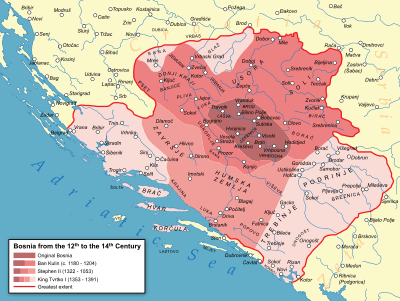
Tropolje or Završje (or Western Regions (Croatian: Zapadne strane) is a historical region[1] of Bosnia and Herzegovina that encompasses territory around karst fields of Livno, Tomislavgrad and Glamoč. The wider zone of this region also comprises the fields of Kupres and Bosansko Grahovo.
Etymology
Name Tropolje derives from the Croatian words tri meaning three and polje meaning field.
Municipalities
Area of Završje covers territory of five municipalities in the Federation of Bosnia and Herzegovina: Grahovo, Glamoč, Kupres, Livno and Tomislavgrad.
| Municipality | Coat of arms | Population[2] | Area (km2)[3] |
|---|---|---|---|
| Bosansko Grahovo | | 3,091 | 780.0 |
| Glamoč | | 4,038 | 1033.6 |
| Kupres | | 5,893 | 569.8 |
| Livno | | 37,487 | 994.0 |
| Tomislavgrad | | 33,032 | 967.4 |
Geography
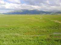
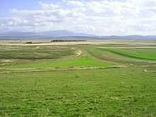
The total area of the Završje is approximately 4,343 square kilometres (1,680 sq mi). The region is located between Dalmatia to the west, Bosanska Krajina to the north, Central Bosnia to the east and Herzegovina to the south and southeast. Završje has population of 68,809—making the region the most sparsely populated region of Bosnia and Herzegovina at 15.84/km2 (41.0/sq mi). Most of the region consists of mountainous terrain separated by karst fields.
Topography
Mountainous terrain of the region is a part of the Dinaric Alps, linked to a Late Jurassic to recent times fold and thrust belt, itself part of the Alpine orogeny, extending southeast from the southern Alps. The Dinarides form part of a chain of mountains that stretch across southern Europe and isolate Pannonian Basin from the Mediterranean Sea. The highest mountain of the Tropolje Dinarides is Mount Vran, located on the border of the municipalities of Tomislavgrad and Jablanica with the peak called Veliki Vran (Great Vran) at 2,074 metres (6,804 ft).
| Highest mountains of Tropolje | |||
|---|---|---|---|
| Mountain | Peak | Elevation | Coordinates |
| Vran | Veliki Vran | 2,074 m (6,804 ft) | 43°40′4.8″N 17°30′18″E / 43.668000°N 17.50500°E |
| Vran | Mali Vis | 2,014 m (6,608 ft) | 43°40′41.34″N 17°29′57.08″E / 43.6781500°N 17.4991889°E |
| Cincar | Cincar | 2,006 m (6,581 ft) | 43°54′08″N 17°03′46″E / 43.90222°N 17.06278°E |
| Vran | Crno Brdo | 1,966 m (6,450 ft) | 43°40′52.96″N 17°29′37.3″E / 43.6813778°N 17.493694°E |
| Vran | Mali Vran | 1,961 m (6,434 ft) | 43°39′8.8″N 17°17′27″E / 43.652444°N 17.29083°E |
| Vran | Bijela Glava | 1,949 m (6,394 ft) | 43°39′34″N 17°29′56″E / 43.65944°N 17.49889°E |
| Vitorog | Veliki Vitorog | 1,907 m (6,257 ft) | 44°7′12″N 17°2′45″E / 44.12000°N 17.04583°E |
| Golija | Veliki Vrh | 1,886 m (6,188 ft) | 43°59′12″N 16°47′21″E / 43.98667°N 16.78917°E |
| Vran | Priorac | 1,881 m (6,171 ft) | 43°39′37″N 17°28′27″E / 43.66028°N 17.47417°E |
| Šator | Veliki Šator | 1,872 m (6,142 ft) | 44°9′26″N 13°35′23″E / 44.15722°N 13.58972°E |
Hydrology and climate
The entire Tropolje region is encompassed by the Adriatic Sea drainage basin except small part of the northern field of Glamoč which is encompassed by the Black Sea drainage basin. Tropolje contains several losing streams such as Bistrica, Sturba, Šujica, Žabljak, Vrba, reflecting a high degree of karstification of the terrain in the region, resulting in increased permeability of soil and rocks. Ingress of water underground resulted in formation of subterranean watercourses and lakes.
History
Tropolje has been inhabited at least since Neolithic times. In the late Bronze Age, the Neolithic population was replaced by more warlike Indo-European tribes known as the Illyrians. The region was inhabited by Illyrian tribe of Dalmatae. Their capital was Delminium which was located in today's Tomislavgrad. The Dalmatae left many remains that testify about their presence in this area. The most important remains are the gradine, remains of Illyrian settlements which were distributed along the karst fields. The settlements were strategically well placed, that is why the Romans took over 200 years to occupy this region.
Culture
Museums and art galleries
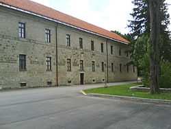
Tropolje is home to few museums, galleries, and other institutions. The first of these is the Museum of the Franciscan Monastery Gorica in Livno, established on 2 October 1995 with the goal of collecting and preserving museum’s holdings from Tropolje region and further. It has its roots in the 19th century and the work of the Franciscans from Livno, who visited archaeological sites collecting antiquities and invested effort in establishing a museum at the monastery. This is reflected in a document from 1896 in which they seek permission from the National Government in Sarajevo to display antique weapons in a public room at the monastery. [4]
Franciscan Monastery in Tomislavgrad has a Museum with archaeological, ethnographic, sacral and African exhibitions. The most significant archaeological finding is the Duvanjska ploča (stone-carved slate) found in the 1960s near the village of Prisoje, dating back to the 2nd century. The Ethnographic collection is composed of traditional attire and jewellery, sacral collection of the 17th and 19th century chalices, and the African collection of artefacts brought from Africa by Franciscan missionaries.[5]
The memorial complex 25 May 1944 in Drvar was established after the World War II near the Tito's cave, and was one of the main tourist attractions in Socialist Federal Republic of Yugoslavia, visited by more than 200,000 tourists a year.[6]
References
- ↑ http://chapters.scarecrowpress.com/08/108/0810850842ch1.pdf
- ↑ "Rezultati popisa 2013. (Census 2013 Results)". http://www.bhas.ba/'' (in Croatian). Agency for Statistics of Bosnia and Herzegovina. Retrieved 7 November 2013.
- ↑ (Bosnian)(Croatian) "Kanton 10 u brojkama (Canton 10 in numbers)". The Federal Office of Statistics of Federation of Bosnia and Herzegovina. Retrieved 28 May 2013.
- ↑ "Povijest muzeja (History of the museum)". http://fmgg-livno.com/'' (in Croatian). Franciscan Museum and Gallery Gorica (FMGG). Retrieved 1 May 2014.
- ↑ "Samostanski muzej (Monastery Museum)". samostan-tomislavgrad.info (in Croatian). Franciscan Monastery Tomislavgrad. Retrieved 1 May 2014.
- ↑ "Tito's cave in Drvar". http://www.exploringbosnia.com/''. Retrieved 1 May 2014.
Coordinates: 43°49′25″N 17°00′15″E / 43.82361°N 17.00417°E