Trimley St Mary
| Trimley St. Mary | |
 Trimley St. Mary |
|
| OS grid reference | TM 281 363 |
|---|---|
| Shire county | Suffolk |
| Region | East |
| Country | England |
| Sovereign state | United Kingdom |
| EU Parliament | East of England |
Coordinates: 51°58′41″N 1°19′23″E / 51.978°N 1.323°E
Trimley St. Mary is a parish and village between Felixstowe and Ipswich in Suffolk, England. Its eastern border is either the Port of Felixstowe Road bridge or Spriteshall Lane. History would dictate that Spriteshall lane is the more likely border.
The village, and its neighbour Trimley St. Martin, are famous for their adjacent churches which were built as the result of a historical family feud St. Mary's church is the southerly church (at grid reference TM 276 369).
The village also contains a number of shops including an Indian Take-Away, a hairdresser, a newsagent and two pubs.
Trimley railway station serves the village on the Felixstowe Branch Line.
According to the 2011 census the population of Trimley was 3,665.[1]
In the 1870s, Trimley St mary was described in this way:
- TRIMLEY-ST. MARTIN and T.-ST. MARY, two parishes in Woodbridge district... The churches stand in one churchyard, and are both rubble buildings.[2]
History
The place name Trimley St. Mary means "Trymma's woodland clearing".[3]

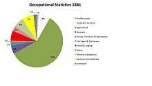
The oldest data on Trimley St Mary is the 1811 census, this data shows that the population of the parish was 346 with a balance of 175 males and 171 females. It also enclosed information on occupations showing that 35 families in the village were chiefly employed in agriculture, 17 in trade/manufacture and the remaining 19 families were unknown or not recorded.[4] There is more data available for the populations occupation in 1881. The breakdown for the males was 57 in agriculture, 7 general commodities, 7 domestic services/offices, 6 in food and lodging and 5 worked with animals. Females however had a completely different breakdown as 26 worked in domestic services and offices and the remaining 76 were unknown.[5] The population of Trimley St Mary has continued to grow since records began in 1801 where the population was only 330[6] but has grown exponentially to 3,665 in 2011[7] According to the recent 2011 census data released the employment in Trimley has altered greatly in time. The percentage of people working in agriculture has declined massively and is now less than 1% of the working population. The biggest increases have been seen in Manufacturing, Wholesale, Retail, Transport, Storage and Education.[8] This fits the general trend of change throughout the rest of England. The Agricultural industry saw large declines, along with most of the primary industry while people moved over to the secondary and tertiary industries in hope of greater pay and better conditions in the workplace.[9]
Present Day
Trimley St. Mary is a small parish lying between Felixstowe and Ipswich. Within this small parish there is a variety of local businesses including Window cleaners, beauticians, photographers, metal works, recycling plants, dog groomers and garages.[10] One independent business that has been given some of the most impeccable reviews is the Brierfield care home that is rated 9.9/10 on average and given no lower than good in all criteria by the reviewers online.[11] The care home was said to have had a "grand extension open in August 2010 and had its existing building refurbished to a very high standard"[12] and has the qualification to provide specialist care for patience with Alzheimer's disease.[13] The Parish also contains Trimley St Mary Primary School which in 2014 catered for 370 pupils and has been in existence since 1904 maintaining a good reputation.[14] There is a local newsletter that is distributed occasionally with no set date, letting the community know of anything interesting happening or coming up.[15]
Every year the two parishes of Trimley take part in the annual Carnival that is held in the summer month of July, the two day event is described as "colourful floats starting at Faulkeners Way at 1300, travelling along High Road, and ending at the Trimley Sports and Social Club where there will be various activities, including a disco, stalls, demonstrations, food and fairground rides, and of course Marty Le Fox, the resident carnival mascot"[16]
In 2013 the majority of houses that were sold in Trimley St. Mary were detached averaging at £227,429. The overall average House prices for the area came out at £184,795 which were said to have been up on the 2012 prices by 10%.[17]
In 2005 environmental information was available in census data and it showed that Trimley St Mary was dominated by greenspace as over 75% of the parish was termed greenspace. If you then include domestic gardens the percentage of area rises to an even bigger 85%, surprisingly this is still below the average for the whole of England.[18]
The majority of the population living in Trimley St Marys are from the United Kingdom as the 2011 census data declared 3493 of the total 3665 people from the UK. Out of the remaining 172 people, 81 came from a European country, 18 were from Africa, 32 from the Middle East and Asia, 31 from the Americas and the Caribbean and the remaining 3 came from Oceania and Antartica. This is a lower number of residents from other countries than the general trend for the UK but is similar to the average for the Suffolk coast.[19]
Places Of Interest
St Marys Church- This church effectively closed in the 1980s and has struggled to ever gain the popularity to reopen as most people have been drawn in to the more exciting churches down in Felixstowe. It is located in adjacent churchyards to its neighbouring parish St Martins. Even though the church no longer functions it is said to have a wonderful array of stain glass windows from the late 19th and 20th century.[20]
Three Mariners Pub- This has been a grade 2 listed building since 1983.[21] The pub holds an annual charity day where local bands come and play, they also supply a barbeque and raffle to raise money.[22]
War Memorial- The war memorial is found inside the St Marys church. There are two different war memorials on display to remember the fallen soldiers of world war 1. The first is a plaque with the names of soldiers on display and a Celtic cross above. The other is a stunning stain glass window dedicated to the soldiers with an image of Christ and his 7 disciples.[23]
The Welcome Hall- This building was first erected in 1902 by the Lord Chancellor of the time, Lord Halsbury and was provided by the Pretyman family. From 1939 onward after the Hall was passed on to village trustees, it was used for recreational purposes and mental/physical training. The Hall received a new roof in 1996 that was in desperate need thanks to the board of trustees. In the present day the Hall can be hired out by groups and is used for many activities such as Yoga, Line dancing, dance, Musical theatre, Zen, WI and PCC meetings.[24]
Transport
A14- The A14 is the nearest main road to Trimley St Marys, it was first built in the 1990s and runs between Felixstowe and the Midlands.[25] The nearest junction is 59 which can be accessed in Trimley.[26]
Trimley St Mary railway station- This station was opened and available for the population of Trimley from 1 May 1891. This station allows cheap commuting for residents of Trimley into Felixstowe.[27]
Airports- The nearest Airport for people living in Trimley St Mary is London Southend Airport which is approximately 62.75 kilometers away.[28] This Airport has international flights incoming and outgoing regularly.[29] The nearest Airport after that is Kent international which is 70.81 kilometers away.[30]
References
- ↑ "Trimley St MAry (Parish): Key Figures for 2011 Census: Key Statistics". Neighbourhood Statistics. Office for National Statistics. Retrieved 5 February 2014.
- ↑ Wilson, John Marius (1870-72). Gazetteer of England and Wales. Edinburgh: A. Fullarton & Co. Check date values in:
|date=(help) - ↑ "University of Nottingham". Key to English Place-Names. Retrieved 21 March 2014.
- ↑ General&ResourceType=TNA&SearchTerms=Trimley&simple=yes&path=Results&active=yes&titlepos=0&mno=5&pageseq=350 "Hist Pop". Online Report. Retrieved 14 March 2014.
- ↑ [URL: http://www.visionofbritain.org.uk/unit/10271812/cube/OCC_ORDER1881 "A Vision Of Britain"]. A Vision Of Britain Through Time. Retrieved 21 March 2014.
- ↑ "Portsmouth University". A Vision of Britain through Time. Retrieved 14 March 2014.
- ↑ "Government Statistics". Office for national statistics. Retrieved 14 March 2014.
- ↑ "Government Statistics". Neighbourhood Statistics. Retrieved 25 March 2014.
- ↑ "International Communist Current". British Agriculture: A History of Decline. World Revolution. Retrieved 25 March 2014.
- ↑ Turner, Martin. "Web developer". Free Index. Retrieved 10 March 2014.
- ↑ "Review Page". Brierfield care home. Retrieved 18 March 2014.
- ↑ "Brierfield care home website". Brierfield care home. Retrieved 18 March 2014.
- ↑ "care home website". Brierfield care home. Retrieved 18 March 2014.
- ↑ "Trimley St. Mary Primary School". Trimley St. Mary Primary School. Retrieved 2 March 2014.
- ↑ "Trimley St. Mary Parish Council". Newsletter. Retrieved 13 March 2014.
- ↑ "Visit Felixstowe". website. Retrieved 13 March 2014.
- ↑ "Property portal". Rightmove. Retrieved 18 March 2014.
- ↑ "Neighbourhood Statistics". Census Data. Retrieved 26 April 2014.
- ↑ "Neighbourhood Statistics". Government Data. Retrieved 26 April 2014.
- ↑ Knott, Simon. "Suffolk Churches". Suffolk Churches. Retrieved 21 March 2014.
- ↑ "English Heritage". British Listed Buildings. Retrieved 21 March 2014.
- ↑ "Ipswich Star". Ipswich Star. Retrieved 21 March 2014.
- ↑ Green, Stuart. "Roll Of Honour". Roll Of Honour. Retrieved 21 March 2014.
- ↑ "Trimley St Mary Parish Council". Parish Council. Retrieved 25 March 2014.
- ↑ "Website for UK roads". Sabre. Retrieved 26 March 2014.
- ↑ Dixon, David. "Photographers". Geograph. Retrieved 26 March 2014.
- ↑ "Railway History Page". Trimley Station Community Trust. Retrieved 26 March 2014.
- ↑ "Trimley St Mary location information". Streetlist. Retrieved 26 March 2014.
- ↑ "Airport Website". London Southend Airport. Retrieved 26 March 2014.
- ↑ "website providing information on Trimley". Streetlist. Retrieved 26 March 2014.
External links
![]() Media related to Trimley St Mary at Wikimedia Commons
Media related to Trimley St Mary at Wikimedia Commons