Trepassey
| Trepassey Trépassés (Dead Men) | |
|---|---|
| Town | |
| Nickname(s): Dead Man's Bay | |
 Trepassey Location of Trepassey in Newfoundland | |
| Coordinates: 46°44.2′N 53°21.80′W / 46.7367°N 53.36333°WCoordinates: 46°44.2′N 53°21.80′W / 46.7367°N 53.36333°W | |
| Country |
|
| Province |
|
| Settled | 1617 |
| Area | |
| • Total | 55.81 km2 (21.55 sq mi) |
| Population (2011) | |
| • Total | 570 |
| • Density | 10.2/km2 (26/sq mi) |
| Time zone | Newfoundland Time (UTC-3:30) |
| • Summer (DST) | Newfoundland Daylight (UTC-2:30) |
| Area code(s) | 709 |
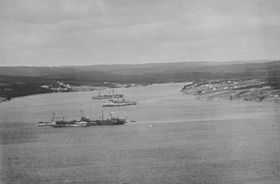
Trepassey 46°44.2′N 53°21.80′W / 46.7367°N 53.36333°W, is a small fishing community located in Trepassey Bay on the south eastern corner of the Avalon Peninsula of Newfoundland and Labrador. It was in Trepassey Harbour where the flight of the Friendship took off, piloted by Amelia Earhart. Amelia became the first woman to fly across the Atlantic Ocean.
_p0694_TREPASSEY_BAY.jpg)

History
Trepassey originates from the French word trépassés, meaning 'dead men'. It is believed that it acquired this name due to the many shipwrecks that have occurred off its coast. Also on the Brittany coast of France there is a Baie des Trépassés. Trepassey is the name of the harbour, the bay and the community. Later the translation was used as 'Dead Man's Bay' due to the tragic shipwrecks along the coast. Alternatively, the 'tre' element of the name could come from the Welsh word for 'town', explained by the Welsh influence of the Vaughan family.
Spanish, Portuguese and French fishermen visited the area in the early 16th century. Early English settlement attempts failed, and it was not until the latter part of the 17th century that the French settled the area. Later fishermen from the West Country of England arrived, to be followed by large numbers of Irish and by the 1770s the Irish formed the majority of the population.
Sightseeing/Activities
Salmon and trout fishing in the bay, nearby lakes and rivers. Caribou and other wildlife are often sighted near town along the road. Trepassey features a museum with artifacts from Amelia Earhart's flight. Cape Race lighthouse is nearby. Capelin fish beach themselves yearly in mid-July, which is also a good time to spot whales feeding on the capelin. One can also collect capelin on the beach at this time.
Timeline
- 1504, Trepassey first appears on European maps as a supply depot.
- 1600s, Trepassey marks the area where the French and Welsh areas of influence in Newfoundland meet.
- 1617, First attempt to settle Trepassey by Sir William Vaughan
- 1675, the French occupy one part of the Trepassey harbour and the English the other side.
- 1713, the Treaty of Utrecht gives control of Trepassey to England. Shortly thereafter, Trepassey becomes a major centre of the English migratory and bank fisheries.
- 1720, on 21 June the pirate Bartholomew Roberts captures and burns 22 vessels in the harbour.
- 1821, the first lighthouse is built at Cape Pine, the southernmost point in Newfoundland.
- 1836, the population is listed as 247.
- 1863, the postmaster was John Devereaix
- 1886, the Way or Post, office closed.
- 1884, population reaches 668.
- 1914, the Newfoundland Railway Branch Line is completed, linking Trepassey with St. John’s.
- 1919, United States Navy Curtiss Flying Boats (the NC-1, NC-3 and NC-4) leave Trepassey harbour on May 16; NC-4 flies to Portugal via the Azores, thus completing the first successful (although not non-stop) transatlantic flight.
- 1928 (June 28), after staying in Trepassey for three weeks, Amelia Earhart as a passenger aboard the Friendship, becomes the first woman to fly across the Atlantic Ocean.
- 1969, the community elects its first town council.
- 1991, the local fish plant closes putting over 600 people out of work.
See also
- List of cities and towns in Newfoundland and Labrador