Trelleborg (Slagelse)
The Trelleborg (or Trælleborg) west of Slagelse on the Danish island of Zealand, is one of seven Viking ring castles discovered as per 2014. In its day, the fortress was situated on a peninsula that jutted into the swampy area between two rivers. The swamp was connected to the Great Belt by a lake that at its time could be navigated by Viking ships. The trelleborg might have commanded the Great Belt and its sea traffic, between the islands of Zealand and Funen.
Layout and construction
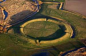
Similar to the other Viking ring castles found so far, the Trelleborg at Slagelse was designed as an exact circle with two roads that crossed at right angles in the geometric center and led to the four gates with two always opposite to each other. In each of the four quarters stood four almost identical longhouses arranged in a square. Unlike the others, the fortress was extended with a sort of bailey. The whole fortress may have supplied room for some 1,300 people.
Main castle
The circular main castle was surrounded by a 5 m high rampart that was 17.5 m wide at the base and had a diameter of 137 m. The outer walling was made of oak. Two rows of poles were supported by slanted beams from the outside and the room in between the poles was filled with loam and stones. The inside was also clad with wood, the two facades were reinforced by beams connecting the two. In the east, there was a 5 m broad berm protected by a ditch with a pointed profile, 17 m wide and 4 m deep. The ditch was not filled with water and had a palisade at its base. The two roads were covered with wood, and the four gates lined with stones on the inside. As in Fyrkat, there may have been a circle path along the inner side of the ramparts.
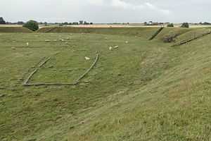
The fortifications encircled a total of 16 longhouses arranged in four squares 29.42 m long each. The houses had a somewhat ship-like form as the long walls were bulging outwards. Each house had four entrances, two at the short ends and two in the long walls, and was divided into three rooms with a large central hall (18 x 8 m) and two smaller rooms at the ends. The doors were protected by porches. Besides the large longhouses, there were also smaller houses to the north of the north eastern quarter, two small houses in the inner yard of the northeastern and southwestern quarter and a little square hut each near the northern and western gates.
Bailey
This part of the fortress seems unique, as the other fortresses seem to lack this feature (so far only Aggersborg, Fyrkat and the Trelleborg near Slagelse have been fully excavated as of 2006). The bailey was protected by a rampart of its own to the east. The 14 longhouses of the bailey, each 26.33 meters long, were placed with their axis through the length of the buildings pointing to the center of the main castle.
In an extension of this bailey was a cemetery with 135 graves. Most buried were young men but some were also women or children. Two contained mass burials, one for five and one for eleven persons. Over two-thirds of the graves had no grave offerings, the others only had few pieces, weapons being rather rare. Only two graves were rich in items. One was a woman's grave with pearls, a bronze bucket, a wood casket and game stones. The other was the grave of a male with a bronze bowl and a silver adorned axe. The large amount of simple graves may indicate a Christian influence. Graves of horsemen were found on surrounding higher grounds.
Excavation and finds
The site was excavated from 1934 to 1942. Most of the finds were things of every day life: pottery, locks, keys, fittings, knives, whetstones, combs, weaving weights, scissors and needles. Weapons such as iron axes, arrow points and parts of shields.
Dating
Older datings put the castle near the year 1000. Datings by Dendrochronology have found the wood used for the construction to have been felled in the fall of 980 and thus being used for building presumably in the spring of 981. The rather short construction time and the complete lack of any signs of maintenance indicate an only short use of the buildings. Possibly the fortress was abandoned before it was completed. Signs of fire may indicate its destruction by fire. The regions around the gates show signs of longer usage though.
Today
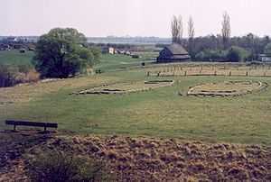
The landscape surrounding the Trelleborg, has changed considerably since the Viking Age, due to a land rise known as post-glacial rebound, that is affecting this part of the world and the swamp has shrunk to a small bog while the two rivers of Vårby Å and Tude Å, has reduced to narrow streams.[2]
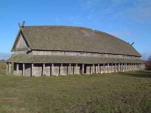
In 1948, one of the Longhouses was reconstructed on the site, but more recent investigations has since led to other opinions on its true original design though. Today the site of the trelleborg is an open air museum with some buildings for exhibits. There are plans for expanding and updating the exhibits and the municipality of Slagelse has also initiated a larger nature restoration project of the entire area of Tude Rivervalley (Danish: Tude Ådal), including the trelleborg.[2][1]
Bibliography
- Steen Wulff Andersen: Vikingeborgen Trelleborg. Museet ved Trelleborg, 1995
- Steen Wulff Andersen: Trelleborg. In: Reallexikon der Germanischen Altertumskunde Bd. 31. Berlin 2006. S. 157–160.
- Bent Jørgensen: Et gensyn med navne Trælleborg. In: Gillian Fellows-Jensen, Niels Lund: Beretning fra fjortene tværfaglige vikingesymposium 1995.
- Eva Nyman: Trælleborg. In: Reallexikon der Germanischen Altertumskunde Bd. 31. Berlin 2006. S. 118–119.
References
- ↑ 1.0 1.1 1.2 "Ny Trelleborg" (in Danish). National Museum of Denmark, Municipality of Slagelse. 2014. Retrieved 7 September 2014.
- ↑ 2.0 2.1 "Tude Ådal" (in Danish). Slagelse Municipality. July 2013. Retrieved 7 September 2014.
|chapter=ignored (help)
External links
| Wikimedia Commons has media related to Trelleborg (Slagelse). |
- Trelleborg homepage for the museum
Coordinates: 55°23′39″N 11°15′55″E / 55.39417°N 11.26528°E