Transport in São Paulo
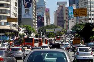

Transport in São Paulo lacks infrastructure, but public transportation plays a key role in day-to-day life of São Paulo. São Paulo has a large bus system with a fleet of over 16,000 buses run by SPTrans. There are also several train systems: CPTM, the São Paulo Metro, and the EMTU-SP, plus various connecting lines. A contactless smartcard solution Bilhete Único (Unified ticket) is used for fare collection and control for buses, subway and train; using the card allows riders discounted prices for multiple rides and makes for easier transitions between transit systems.[1]
Intra-City transport
Buses

Over 16,000 buses form the bulk of public transport in São Paulo; they include about 290 trolley buses.[2] Except for a small network overseen by EMTU, all bus lines are operated by concessionaires under the supervision of SPTrans (São Paulo Transporte SA), a municipal company responsible for planning and management of public transport. The SPTrans fleet is coloured uniformly; some vehicles are painted in white, while others are painted with colors that correspond to the particular non-central region served (e.g., light green for the buses that serve the northwest region, dark blue for the northern area). Until a few years ago, informal transport vans (dab vans) had a large presence in the city, but the vast majority of such vans are now already fully registered with the city council, legalized and operating under the same color scheme used for the main system. To assist in the smooth flow of traffic, several busways were built throughout the city. Besides these corridors, the city has a system called Expresso Tiradentes, with a considerable expansion already under construction. The payment of fares on buses can be made in cash or by a stored-value card called Bilhete Único.
Gallery
São Paulo buses
-

Low floor Trolleybus.
-

Low floor bus in São Paulo.
-

Bus CAIO Millennium.
Rail transport
Underground and light rail system


The city has 61.5 km of underground railway systems (34.6 km fully underground) (the São Paulo Metro,[3] locally known as the Metrô), with 4 lines in operation and 58 stations, complemented by another 260.7 km of Companhia Paulista de Trens Metropolitanos (CPTM, or "Paulista Company of Metropolitan Trains") railways. Both CPTM and the underground railway lines carry some 5.2 million people on an average weekday, and a few new underground lines to be constructed are expected to add another million people to the system within the next five years. The projects expected to expand São Paulo's urban railway system from the current 322.2 km to more than 500 km on the next 10 years.[4]
São Paulo has three rapid transport systems:
- The underground rail system (called "metrô", short for "metropolitano"), with three completed and two partially completed lines.
- The suburban rail system, Companhia Paulista de Trens Metropolitanos (CPTM), has six lines that serve many regions not reached by the underground system, and even some other cities in the metropolitan region. The CPTM network is longer than the underground rail system.
- The fast-lane bus system: there are many such bus lines in the city, called "Passa Rápido", which are street-level, placed on large avenues, and connected with the underground or suburban train stations.
São Paulo has no tram lines, although trams used to be common in the first half of the 20th century.[5]
São Paulo's underground train system is modern, safe, clean and efficient, considered one of the best subway systems in the world, as certified by the NBR ISO 9001. It has five lines and links to the metropolitan train network, the CPTM.
The underground rail lines are:
- São Paulo Metro
- Line 1 - Blue: The first Metrô line built connects the North and the South Side of São Paulo. Connections are available for the Green, Red and Yellow lines and also for CPTM trains. Tietê and Jabaquara bus terminals are also reachable through the use of this line.
- Line 2 - Green: The Green line transverses the Avenida Paulista ridge, connecting Ipiranga to Vila Madalena, and also integrating the Blue and Yellow lines.
- Line 3 - Red: One of São Paulo's busiest lines, it connects the East Side to the West Side. Connections to the Blue and Yellow lines are possible, as are with CPTM trains. The Barra Funda bus terminal is located on this line.
- Line 4 - Yellow: The Yellow line connects the central Luz station to the South side in a route constructed immediately below the Consolação and Rebouças avenues. Connections are available to the Blue, Green and Red lines and to CPTM trains.
- Line 5 - Lilac: Built for users who need to reach specific places in São Paulo's South Side. Only a short distance of the line is already available (six complete stations), connecting to CPTM trains at Santo Amaro station.
- Line 6 - Orange (planned): Announced in 2008 and scheduled to be open in 2012, the Orange Line will connect the borough of Freguesia do Ó, in the northwestern side of the city to downtown São Paulo. It will be connected to the subway lines 1 and 4, as well as the line 7 of CPTM.
- CPTM:
The following lines are composed by surface trains and managed by CPTM, named after precious stones:
- Line 7 - Ruby: Formerly the northern part of the old São Paulo Railway, it connects the Luz station downtown to the city of Francisco Morato, crossing all of the northwestern side of the city. An operational extension connects Francisco Morato to the city of Jundiaí. This is the longest line of the railway system in São Paulo.
- Line 8 - Diamond: Formerly part of the old Estrada de Ferro Sorocabana, it connects the Julio Prestes station downtown to Itapevi, going across the western side of the city. An operational extension with another train links this line to four more stations in Itapevi. The last station (Amador Bueno) is placed near the border with São Roque. The Julio Prestes station houses the State of the Art concert hall Sala Cidade de São Paulo.
- Line 9 - Emerald: It's located along the Nações Unidas Avenue (Marginal Pinheiros), and connects the region of the Interlagos Speedway to the neighbouring city of Osasco. Presently, it makes the only connection with the subway Line 5 - Lilac.
- Line 10 - Turquoise: Formerly the southern part of the old São Paulo Railway, it's actually a continuation of the Line 7 - Ruby, and crosses the ABC Region.
- Line 11 - Coral: Also known as "Expresso Leste" (East Express), it crosses all the eastern side of São Paulo from downtown, to Guaianases. It is within the largest distance between two stations (between Tatuapé and Itaquera) in all the railway net. There is an operational extension from Guaianases to the campus of the Universidade de Mogi das Cruzes, in the city of Mogi das Cruzes.
- Line 12 - Sapphire: It crosses the northeastern side of São Paulo, from the Brás station downtown until the city of Itaquaquecetuba.
Future complete system
This table includes future extensions and lines for Metro and CPTM:
| Line | Color | Terminals | Length (km) | Stations | System |
|---|---|---|---|---|---|
| 1 | Blue | Tucuruvi ↔ Jabaquara | 20.2 | 23 | Metro |
| 2 | Green | Vila Madalena ↔ Cidade Tiradentes | 38.4 | 31 | Metro |
| 3 | Red | Palmeiras-Barra Funda ↔ Corinthians-Itaquera | 22 | 18 | Metro |
| 4 | Yellow | Luz ↔ Vila Sônia | 12.8 | 11 | Metro |
| 5 | Lilac | Capão Redondo ↔ Chácara Klabin | 19.8 | 17 | Metro |
| 6 | Orange | Brasilândia ↔ Ipiranga | 18.4 | 17 | Metro |
| 7 | Ruby | Luz ↔ Jundiaí | 60.5 | 19 | CPTM |
| 8 | Diamond | Júlio Prestes ↔ Amador Bueno | 41.7 | 24 | CPTM |
| 9 | Emerald | Osasco ↔ Grajaú | 31.8 | 18 | CPTM |
| 10 | Turquoise | Luz ↔ Rio Grande da Serra | 37.2 | 14 | CPTM |
| 11 | Coral | Luz ↔ Estudantes | 50.8 | 17 | CPTM |
| 12 | Sapphire | Brás ↔ Calmon Viana | 38.8 | 16 | CPTM |
| 13 | Jade | Brás ↔ Zézinho Magalhães | 20.8 | 5 | CPTM |
| 14 | Onyx | Luz ↔ Aeroporto Internacional de Guarulhos/Cumbica | 28.3 | 3 | CPTM |
| 15 | White | Vila Prudente ↔ Tiquatira | 10 | 9 | Metro |
| 16 | Silver | Cachoeirinha ↔ Lapa | 9 | 10 | Metro |
| 17 | Gold | São Paulo - Morumbi ↔ São Judas / Jabaquara | 21.5 | 20 | Metro |
| ABC Express | Turquoise | Luz ↔ Mauá | 25.2 | 6 | CPTM |
| Suzano-Estudantes Light Rail | Coral | Suzano ↔ Estudantes | 13.8 | 11 | CPTM |
| Grand Total | - | - | 521 | 289 | - |
Air
Airports
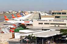

São Paulo has three airports. There are two major airports in the São Paulo metropolitan area: São Paulo/Guarulhos International Airport (IATA: GRU) for domestic and international flights and Congonhas-São Paulo Airport (IATA: CGH) for domestic flights. There's also a small airport known as Campo de Marte north of the Old Center for small, private aircraft and helicopters. Campo de Marte also hosts the Ventura Goodyear Blimp.
Congonhas Airport operates domestic and regional flights, mainly to Rio de Janeiro, Belo Horizonte and Brasília. Campo de Marte airport handles some private and small-sized airplanes. Guarulhos International Airport, also known to São Paulo dwellers as "Cumbica", is located 25 km North East of the city centre, in the neighbouring city of Guarulhos. Guarulhos airport operates both domestic and international flights.
On 17 July 2007 the worst airline accident in Brazil's history occurred at Congonhas airport, blamed on rain and a shortended runway. 199 people from the plane and on the ground died. Following the accident, pilots refused to land under rainy conditions and the Brazilian President signed an act so that ticket sales for flights to the airport be stopped. Aviation throughout the entire country reached a crisis state, which is slowly being overcome by new safety measures such as the introduction of a grooved pavement in the runways.
In 2006, about 34.3 million people went through the city's airports (mainly from Congonhas and Guarulhos International Airport, the only two operating commercial flights). Infraero, Brazil's main aviation authority, estimates that with the remodelling of Guarulhos Airport, São Paulo's airports will be able to handle about 45 million passengers a year within the next five years. There are also plans to expand the Viracopos-Campinas International Airport at Campinas, a city about 90 km North of São Paulo.
São Paulo has allegedly one of the highest per capita helicopter ownership in the world. The owners are an elite wealthy class who take advantage of around one hundred helipads and heliports to conveniently avoid heavy traffic.
Main Brazilian airlines

- TAM Airlines
- Gol Transportes Aéreos
- Azul Brazilian Airlines
- Avianca Brasil
Heliports
São Paulo has the largest fleet of helicopters in the world, with around 500 registered helicopters and 700 flights per day in the city.[6] Modern is one of the symbols of the so-called top of the circle makes the mainland economy and faster, being increasingly used by the richest of the city to escape major congestion. There are many air taxi companies in the city, more used by executives to travel in the fast axis Rio-São Paulo.
Motorways

Roads
Many Brazilian highways pass through or start in São Paulo, such as BR-116, Rodovia dos Bandeirantes, Rodovia Raposo Tavares, the Rodovia Anhangüera, Rodovia dos Imigrantes, Rodovia Castelo Branco, and Via Dutra.
Rodoanel
The Rodoanel Mario Covas (SP-21) (also known as Rodoanel Metropolitano de São Paulo or simply Rodoanel) is a motorway being built around the center of the metropolitan region of São Paulo in an attempt to alleviate the intense traffic of trucks along the city's two riverside highways (Pinheiros and Tietê).
The Rodoanel is being constructed as a multi-lane, limited-access freeway, with large sections to be built in unoccupied regions, along the edge of forests, or close to residential areas, in an effort to prevent squatting and development in environmentally sensitive areas along the route. Nevertheless, the announcement of the planned route provoked intense property speculation in these regions. Construction is being carried out in four phases - west, south, east and north. As of mid-2010, the West and south section have been completed. The beginning of construction on the east section is planned for February 2011. Due to rougher terrain and environmental concerns, there is no projected date for the initiation of construction on the northern section.
IMPORTANT INFORMATION; If you want to drive a car in the city of São Paulo, please note that during the week you have to respect a special schedule according to your car's license, example: on Mondays, the car's licenses ending with the numbers '1 or 2' can not be used; on Tuesdays, you can not drive your car if it ends with '3 or 4", and so on, until Fridays, when the finals "9 or 0" are forbidden. If you don't obey that rule you will have to pay a fine.
Roads interconnected
| West (2002) | South (2010) | East (2014) | North (2018) |
| |
|
|
|
| |
|
|
|
| |
SP-66 | ||
| |
|||
| |
|||
| |
References
- ↑ "Bilhete Único details" (in Portuguese). São Paulo, Brazil: SPTrans. Retrieved January 12, 2010.
- ↑ Webb, Mary (Ed.) (2009). Jane's Urban Transport Systems 2009-2010, pp. 42/6. Coulsdon (UK): Jane's Information Group. ISBN 978-0-7106-2903-6.
- ↑ Downloadable map (pdf) of the underground network retrieved from the Metro SP website.
- ↑ All the main projects from the São Paulo railway and underground system for the next 10 years can be found on the Metrô website and CPTM (in Portuguese).
- ↑ For the history of São Paulo tramways, see Tramz website
- ↑ http://lab.org.uk/sao-paulo-the-worlds-biggest-helicopter-fleet
| ||||||||||||||||||||||||||||