Transport in Ecuador
Transportation in Ecuador
Aviation
National airlines
- Avianca
- LAN Airlines
- TAME (flag carrier)
Airports
359 (2006 est.)
Airports - with paved runways
- total: 98
- over 3,047 m: 3
- 2,438 to 3,047 m: 4
- 1,524 to 2,437 m: 19
- 914 to 1,523 m: 29
- under 914 m: 43
Airports – with unpaved runways
- total: 261
- 914 to 1,523 m:33
- under 914 m:228
Heliports
- 2 (2010)
Highways
- total: 43,197 km
- paved: 6,467 km
- unpaved: 36,730 km (2004 est.)
The Sierra Region still plays an important role in transportation throughout the country. The Pan-American Highway crosses it from North to South. Ecuador has managed to update some roads into 4-lane freeways:
- Quito - Alpichacas. Length: 33 km.
- Guayaquil ring-road. Length: 46 km.
- Guayaquil - Taura. Length: 30 km.
- Guayaquil - Cerro Blanco. Length: 27 km.
- Machala - Pasaje. Length: 23 km.
Bus transport
Pipelines
- crude oil 800 km
- petroleum products 1,358 km
Ports and harbors
Pacific Ocean
- Esmeraldas
- Guayaquil, La Libertad
- Manta
- Puerto Bolívar
- San Lorenzo
Merchant marine
total:
31 ships (1,000 gross register tons (GRT) or over) totaling 184,819 GRT/300,339 tonnes deadweight (DWT)
ships by type: (2006 est.)
- Chemical tanker 1
- gas carrying tanker 1
- Passenger ships 7
- Petroleum tankers 21
- Specialized tanker 1
Foreign-owned: 2
- Norway 1,
- Paraguay 1
Registered in other countries 1
- Georgia 1
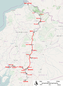
Railways

━━━ Routes with passenger traffic
━━━ Routes in usable state
·········· Unusable or dismantled routes
total:
812 km (single track)
narrow gauge:
812 km 3 ft 6 in (1,067 mm) gauge
There is a proposed rail connection with Colombia. On 5 July 2008 a meeting took place between Venezuela, Colombia and Ecuador regarding a railway for freight and passengers to link the three countries, and linking the Pacific with the Atlantic also. There is no railway service to Peru.
Waterways
1,500 km
References
![]() This article incorporates public domain material from websites or documents of the CIA World Factbook.
This article incorporates public domain material from websites or documents of the CIA World Factbook.
| |||||||||||||||||

.svg.png)