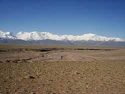
Trans-Alay Range
| Trans-Alay Range | |
|---|---|
|
Trans-Alay Range and Alay Valley | |
| Highest point | |
| Peak | Lenin Peak |
| Elevation | 7,134 m (23,406 ft) |
| Dimensions | |
| Length | 250 km (160 mi) E-W |
| Width | 40 km (25 mi) N-S |
| Naming | |
| Native name | Чоң Алай кырка тоосу |
| Geography | |
| Country | Kyrgyzstan, Tajikistan |
| State/Province | Osh Province |
| Geology | |
| Type of rock |
Composed of limestone and schist of Paleozoic and Mesozoic |
The Trans-Alay Range (also Trans Alai) is the northernmost range of the Pamir Mountains, where the Pamirs and the Tian Shan come together. They form the border between Osh Province, Kyrgyzstan and Gorno-Badakshan province, Tajikistan. To the north is the Alay Valley and to the south, the Muksu River. The highest peak in the range is Lenin Peak.[1]
References
- ↑ Ошская область:Энциклопедия [Encyclopedia of Osh Oblast] (in Russian). Frunze: Chief Editorial Board of Kyrgyz Soviet Encyclopedia. 1987. p. 448.
