Trail, Missouri
| Trail, Missouri | |
|---|---|
| Community | |
 Trail, Missouri Location of Trail, Missouri | |
| Coordinates: 36°46′5″N 92°17′43″W / 36.76806°N 92.29528°WCoordinates: 36°46′5″N 92°17′43″W / 36.76806°N 92.29528°W[1] | |
| Country | U. S. A. |
| State | Missouri |
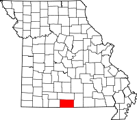
| County | Ozark County |
| Elevation[1] | 230 m (750 ft) |
| Time zone | CST (UTC-6) |
| • Summer (DST) | CDT (UTC-5) |
Trail, Missouri is an unincorporated community in northern Ozark County. It is located about twenty-two miles northeast of Gainesville. Access is from Missouri Route 14 in Douglas County south via route AC. The village site is located adjacent to Trail Creek. Trail Creek flows into Bryant Creek about one mile to the southwest. The Trail cemetery lies about a mile to the northeast along Trail Creek.[1]
History
Trail had a post office from 1890 until 1898. The community name was for the family name of local residents.[2]
References
- ↑ 1.0 1.1 1.2 Gentryville, Missouri, 7.5 Minute Topographic Quadrangle, USGS, 1973
- ↑ Ozark County Place Names, 1928-1945, The State Historical Society of Missouri
| |||||||||||||||||||||||||||||