Touro, New Orleans
| Touro | |
| New Orleans Neighborhood | |
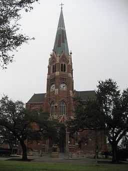
 St. Stephen's Church on Napoleon Avenue | |
| Country | United States |
|---|---|
| State | Louisiana |
| City | New Orleans |
| Planning District | District 2, Central City/Garden District |
| Elevation | 3 ft (0.9 m) |
| Coordinates | 29°55′27″N 90°05′46″W / 29.92417°N 90.09611°WCoordinates: 29°55′27″N 90°05′46″W / 29.92417°N 90.09611°W |
| Area | 0.30 sq mi (0.8 km2) |
| - land | 0.30 sq mi (1 km2) |
| - water | 0.00 sq mi (0 km2), 0% |
| Population | 1,761 (2010) |
| Density | 5,870 / sq mi (2,266 / km2) |
| Timezone | CST (UTC-6) |
| - summer (DST) | CDT (UTC-5) |
| Area code | 504 |
Touro is a neighborhood of the city of New Orleans. A subdistrict of the Central City/Garden District Area, its boundaries as defined by the City Planning Commission are: St. Charles Avenue to the north, Toledano Street to the east, Magazine Street to the south and Napoleon Avenue to the west.
Geography
Touro is located at 29°55′27″N 90°05′46″W / 29.92417°N 90.09611°W [1] and has an elevation of 3 feet (0.9 m).[2] According to the United States Census Bureau, the district has a total area of 0.30 square miles (0.8 km2). 0.30 square miles (0.8 km2) of which is land and 0.00 square miles (0.0 km2) (0.0%) of which is water.
Adjacent Neighborhoods
- Milan (north)
- Garden District (east)
- East Riverside (south)
- Uptown (west)
Boundaries
The City Planning Commission defines the boundaries of Touro as these streets: St. Charles Avenue, Toledano Street, Magazine Street and Napoleon Avenue.[3]
Demographics
As of the census of 2000, there were 3,242 people, 1,672 households, and 482 families residing in the neighborhood.[4] The population density was 10,807 /mi² (4,053 /km²).
As of the census of 2010, there were 2,998 people, 1,572 households, and 429 families residing in the neighborhood.[4]
See also
- New Orleans neighborhoods
References
- ↑ "US Gazetteer files: 2010, 2000, and 1990". United States Census Bureau. 2011-02-12. Retrieved 2011-04-23.
- ↑ "US Board on Geographic Names". United States Geological Survey. 2007-10-25. Retrieved 2008-01-31.
- ↑ Greater New Orleans Community Data Center. "Touro Neighborhood". Retrieved 2008-06-21.
- ↑ 4.0 4.1 "Touro Neighborhood". Greater New Orleans Community Data Center. Retrieved 6 January 2012.
| ||||||