Totteridge Common
Totteridge Common is a 3.7 hectare[1] Site of Borough Importance for Nature Conservation, Grade II, in Totteridge in the London Borough of Barnet.[2][3] The nature reserve is the southern verge of the road Totteridge Common, between Totteridge Park and Oak Lodge. It is registered common land[4] owned by the Totteridge Manor Association.[5]
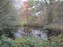
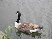
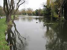
The most interesting feature ecologically is a chain of old ponds. Starting from the east, they are Burnham's Pond, Warren Pond, Long Pond, Ellern Mede Pond and Pink Cottage Pond. They vary in character, but all have interesting wetland flora, and most are valuable for dragonflies, other invertebrates and amphibians. Plants to be found around the edges of the ponds include lesser spearwort, trifid bur-marigold and fool's watercress (Apium nodiflorum). In deeper water, white water-lily and curled and broad-leaved pondweeds can be found. Long Pond is used for angling.[2]
The common also has grassland, scattered trees, overgrown hedgerows and several pockets of scrubby woodland. The woodland is mainly composed of sycamore and elm. Other trees include two young native black poplar (Populus nigra ssp betulifolia), a rare tree in Britain and a priority species in the London Biodiversity Action Plan. There are also some fine mature oaks and horse-chestnuts scattered throughout the common. The grassland has a fairly good range of wild flowers, and damp areas near some of the ponds contain much tufted hair-grass.[2]
See also
- Nature reserves in Barnet
External links
- Totteridge Common on the VisitWoods website
References
- ↑ Mill Hill East Environmental Statement
- ↑ 2.0 2.1 2.2 "Totteridge Common". Greenspace Information for Greater London. 2006. Retrieved 9 September 2012.
- ↑ "iGiGL – helping you find London’s parks and wildlife sites". Greenspace Information for Greater London. 2006.
- ↑ "The Common Lands of Greater London: A biological Survey". Department for Environment, Food and Rural Affairs. p. 30.
- ↑ Totteridge Manor Association home page
Further reading
- Hewlett, Janet (1997). Nature Conservation in Barnet. London Ecology Unit. ISBN 1 871045 27 4.
Coordinates: 51°37′53″N 0°13′22″W / 51.6315°N 0.2227°W