Totonicapán
| Totonicapán | |
|---|---|
| Municipality | |
| Nickname(s): Toto | |
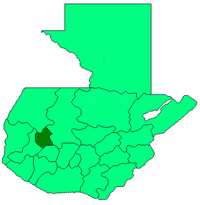
 Totonicapán Location in Guatemala | |
| Coordinates: 14°54′39″N 91°21′38″W / 14.91083°N 91.36056°WCoordinates: 14°54′39″N 91°21′38″W / 14.91083°N 91.36056°W | |
| Country |
|
| Department |
|
| Municipality | Totonicapán |
| Government | |
| • Type | Municipal |
| Area[1] | |
| • Total | 328 km2 (127 sq mi) |
| Elevation | 2,495 m (8,186 ft) |
| Population (census 2002)[2] | |
| • Total | 96,392 |
| • Density | 293/km2 (760/sq mi) |
| • Ethnicities | K'iche' people, Ladino |
| • Religions | Roman Catholicism, Evangelicalism, Maya |
| Climate | Cwb |
Totonicapán is a city in Guatemala. It serves as the capital of the department of Totonicapán and as the administrative seat for the surrounding municipality of Totonicapán.
Historically, Totonicapán was known for its hot springs.[3]

Municipal Theater of Totonicapán
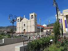
Central plaza in Totonicapán

Municipal building of Totonicapán
References
- ↑ "Totonicapán - Estrategia para la reducción de la pobreza municipal". SEGEPLAN. 2003. Retrieved 2008.
- ↑ "XI Censo Nacional de Poblacion y VI de Habitación (Censo 2002)". INE. 2002.
- ↑ Baily, John (1850). Central America; Describing Each of the States of Guatemala, Honduras, Salvador, Nicaragua, and Costa Rica. London: Trelawney Saunders. p. 85.
External links
| |||||||||||||