Torrijos, Marinduque
| Torrijos | ||
|---|---|---|
| Municipality | ||
| ||
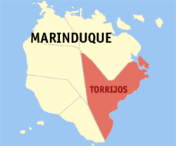 Map of Marinduque showing the location of Torrijos | ||
.svg.png) Torrijos Location within the Philippines | ||
| Coordinates: 13°19′N 122°05′E / 13.317°N 122.083°ECoordinates: 13°19′N 122°05′E / 13.317°N 122.083°E | ||
| Country |
| |
| Region | MIMAROPA (Region IV-B) | |
| Province | Marinduque | |
| District | Lone district of Marinduque | |
| Founded | 1880 | |
| Barangays | 25 | |
| Government | ||
| • Mayor | Gil Briones (Lakas–CMD) | |
| • Vice Mayor | Robert Macdon (Liberal) | |
| Area[1] | ||
| • Total | 178.92 km2 (69.08 sq mi) | |
| Population (2010)[2] | ||
| • Total | 29,366 | |
| • Density | 160/km2 (430/sq mi) | |
| Time zone | PST (UTC+8) | |
| ZIP code | 4903 | |
| Dialing code | 42 | |
| Income class | 3rd class municipality | |
| Website |
torrijosmarinduque | |

Torrijos is a fourth class municipality in the province of Marinduque, Philippines. According to the 2010 census, it has a population of 29,366 people.[2]
Barangays
Torrijos is politically subdivided into 25 barangays.[1]
- Bangwayin
- Bayakbakin
- Bolo
- Bonliw
- Buangan
- Cabuyo
- Cagpo
- Dampulan
- Kay Duke
- Mabuhay
- Makawayan
- Malibago
- Malinao
- Maranlig
- Marlangga
- Matuyatuya
- Nangka
- Pakaskasan
- Payanas
- Poblacion
- Poctoy
- Sibuyao
- Suha
- Talawan
- Tigwi
History
On September 13, 1900, during the Philippine-American War an engagement in Torrijos plotted the forces of Colonel Maximo Abad and American, Devereux Shields, in which Abad's men annihilated the American force, it was one of the worst defeats suffered by the Americans during the war. This was known as the Battle of Pulang Lupa which took place in Torrijos. A monument now stands on the mountain where the battle took place, known as Pulang Lupa, an also as "Red Mountain" due to the red soil, which is a name also said to represent the blood lost during the battle, the bloodshed during and after the Philippine-American War.
In 1942, the Japanese occupied the town of Torrijos, Marinduque.
In 1945, in the Battle of Marinduque, American and Filipino troops fought in and around the town of Torrijos and Marinduque, against the attack of Japanese soldiers during World War II.
Demographics
| Population census of Torrijos | ||
|---|---|---|
| Year | Pop. | ±% p.a. |
| 1990 | 25,496 | — |
| 1995 | 25,807 | +0.23% |
| 2000 | 28,000 | +1.76% |
| 2007 | 29,360 | +0.66% |
| 2010 | 29,366 | +0.01% |
| Source: National Statistics Office[2][3] | ||
Educational institutions
Tertiary
- Marinduque State College
- TPSAT
Secondary
- Bonliw National High School
- Malibago National High School
- Maranlig National High School
- Matuyatuya National High School
- Poctoy National High School
- Sibuyao National High School
- Tigwi National High School
- Our Mother of Perpetual Succor Academy
Primary
- Bangwayin Primary School
- Banukbok Primary School
- Bayakbakin Primary School
- Bolo Primary School
- Bonliw Elementary School
- Buangan Elementary School
- Cabuyo Elementary School
- Cagpo Primary School
- Dampulan Elementary School
- Kay Duke Primary School
- Mabuhay Primary School
- Makawayan Elementary School
- Malibago Elementary School
- Malinao Primary School
- Maranlig Elementary School
- Marlangga Elementary School
- Matuyatuya Elementary School
- Nangka Elementary School
- Pakaskasan Primary School
- Payanas Elementary School
- Poctoy Elementary School
- Sibuyao Elementary School
- Sinambahan Primary School
- Suha Elementary School
- Talawan Elementary School
- Tigwi Elementary School
- Torrijos Central School
References
- ↑ 1.0 1.1 "Province: MARINDUQUE". PSGC Interactive. Makati City, Philippines: National Statistical Coordination Board. Retrieved 26 July 2013.
- ↑ 2.0 2.1 2.2 "Total Population by Province, City, Municipality and Barangay: as of May 1, 2010". 2010 Census of Population and Housing. National Statistics Office. Retrieved 2012-10-24.
- ↑ "Province of Marinduque". Municipality Population Data. LWUA Research Division. Retrieved 25 July 2013.
External links
- Philippine Standard Geographic Code*
- Official Website of Municipality of Torrijos*
- Philippine Census Information
- Local Governance Performance Management System
 |
Santa Cruz | | ||
| Boac Buenavista |
|
Mompong Pass | ||
| ||||
| | ||||
| Sibuyan Sea |
| ||||||||||