Torrelodones
| Torrelodones | |||
|---|---|---|---|
| |||
 Location in the Community of Madrid, Spain | |||
| Coordinates: 40°34′40″N 3°55′40″W / 40.57778°N 3.92778°W | |||
| Country | Spain | ||
| Autonomous community | Community of Madrid | ||
| Province | Madrid | ||
| Comarca | Madrid metropolitan area | ||
| Administrative Divisions | 3 | ||
| Government | |||
| • Mayor | Elena Biurrun ((VxT)) | ||
| Area | |||
| • Land | 21 km2 (8 sq mi) | ||
| Elevation | 844 m (2,769 ft) | ||
| Population (2009) | |||
| • Total | 21,781 | ||
| Time zone | CET (UTC+1) | ||
| • Summer (DST) | CEST (UTC+2) | ||
| Postal code | 28250 | ||
| Area code(s) | 34 (Spain) + 91 (Madrid) | ||
| Website | www.ayto-torrelodones.org (Spanish) | ||
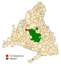
Torrelodones is a municipality in the northwest of the Autonomous Community of Madrid, Spain. It is situated 29 kilometers northwest from the city of Madrid. Because of its location between the Sierra de Guadarrama and the metropolitan area of the capital, it is linked to two districts in Madrid: the agricultural area of Guadarrama and the metropolitan area of Madrid.
It lies at an average altitude of 845 meters. According to the 2009 census, 21,781 people live in the municipality, distributed among seven towns.
The people of Torrelodones earn among the highest per capita incomes of the Community of Madrid. Services, hotels, and construction are the main economic activities.
Coordinates: 40°34′40″N 3°55′40″W / 40.57778°N 3.92778°W
External links
| Wikimedia Commons has media related to Torrelodones. |