Torreón
| Torreón | ||
|---|---|---|
| Municipal seat | ||
 | ||
| ||
| Nickname(s): La Perla de La Laguna | ||
|
Torreón Location in Mexico | ||
| Coordinates: 25°32′21.66″N 103°26′55.08″W / 25.5393500°N 103.4486333°WCoordinates: 25°32′21.66″N 103°26′55.08″W / 25.5393500°N 103.4486333°W | ||
| Country |
| |
| State | Coahuila | |
| Municipality | Torreon | |
| Established | September 25, 1893 | |
| Declared city: | September 15, 1907 | |
| Government | ||
| • Mayor | Miguel Ángel Riquelme Solís (PRI) (2014–2017) | |
| Elevation | 1,120 m (3,670 ft) | |
| Population (2010) | ||
| • Municipal seat | 639,629[1] | |
| • Metro | 1,215,993 | |
| Time zone | CST (UTC−6) | |
| • Summer (DST) | CDT (UTC−5) | |
| Area code(s) | 871 | |
| Website | Official site | |

Torreón (Spanish pronunciation: [toreˈon]) is a city and seat of the surrounding municipality of the same name in the Mexican state of Coahuila. As of 2010, the city's population was 608,836 with 639,629 in the municipality.[1] The metropolitan population, including Matamoros, Coahuila, and Gómez Palacio and Lerdo in adjacent Durango, was 1,215,993. It is the ninth-biggest metropolitan area in the country and is one of Mexico's most important economic and industrial centers. Torreón is served by Francisco Sarabia International Airport, an airport with flights to several cities in Mexico and the United States.
History
According to archaeological findings, the area of Torreón was populated around the 10th millennium BC.
The first Spanish mission arrived in 1566, led by Fr. Pedro Espinareda. However, the city developed only in the independent Mexican era, around a Torreón ("Big Tower") built to monitor Río Nazas's floods, in conjunction with the creation of a railroad connecting to the US border city of El Paso, which gave an economic boom to the city and therefore a population boom as well. The population grew from 200 in 1892 to 34,000 in 1910. Torreón received city status in 1907.
During the Mexican Revolution, the city was taken more than once; the most prominent character ever to take the city was the revolutionary general Pancho Villa. It was also the location of the Torreón massacre, where 303 Chinese immigrants were killed by the revolutionaries over a ten-hour period.[2] During the revolution, Torreon was also the site to an important convention which led to a deal between the insurrected armies.
After the Mexican Revolution, the city continued to develop economically; during the first years of the 20th century the primary industry of the city was farming, although other industries later formed or were established in the area.
On September 15, 2007, Torreón celebrated its first 100 years as a chartered city. It held a series of cultural events from September 15, 2006 to September 15, 2007, culminating on the day that the city turned 100 years old.

Geography and climate


Torreón is near the southwest border of the state of Coahuila, within the Laguna region of the state. The border is delineated by the Nazas River that separates it from Gómez Palacio, Durango. The municipality covers 1,947.7 km2 (752.0 sq mi), including much of the rural area south of the city. Its elevation is over 1,000 m (3,280 ft), which is low for the Mexican interior. The terrain where the urban area is spread is generally flat, with somewhat prominent relief formations (up to 1,600 m (5,249 ft) south and southwest of the city, thus visible at well-nigh any given point in the city. Higher mountains, over 3,000 m (9,843 ft), are on the southern, mostly uninhabited section of the Municipality, the most prominent being El Picacho.
The cities of Torreón, Gómez Palacio, and Lerdo compose La Laguna (The Lagoon) or Comarca Lagunera, a basin within the Chihuahuan Desert, which has much economic activity. The name of the region stems from three nearby, and now dry lagoons, the Lagoon of Mayran, the Lagoon of Tlahualilo and the Lagoon of Viesca.
The region's climate is arid: rainfall is scarce but more prominent in summer, whilst temperatures are very hot by day and cool at night, although the urban heat island effect causes temperatures on summer nights to be considerably warmer than nearby areas. Flora and fauna are those common to semidesert habitats.
The city is 56 km (35 mi) southwest of historic San Pedro de las Colonias, where some of the Mexican Revolution fighting occurred.
| Climate data for Torreón (1951–2010) | |||||||||||||
|---|---|---|---|---|---|---|---|---|---|---|---|---|---|
| Month | Jan | Feb | Mar | Apr | May | Jun | Jul | Aug | Sep | Oct | Nov | Dec | Year |
| Record high °C (°F) | 38.0 (100.4) |
38.5 (101.3) |
42.0 (107.6) |
44.6 (112.3) |
47.0 (116.6) |
45.9 (114.6) |
45.0 (113) |
42.7 (108.9) |
41.0 (105.8) |
40.0 (104) |
40.0 (104) |
36.0 (96.8) |
47.0 (116.6) |
| Average high °C (°F) | 22.3 (72.1) |
25.3 (77.5) |
26.0 (78.8) |
32.5 (90.5) |
35.3 (95.5) |
35.4 (95.7) |
34.3 (93.7) |
33.7 (92.7) |
31.8 (89.2) |
29.5 (85.1) |
26.1 (79) |
22.8 (73) |
29.6 (85.3) |
| Daily mean °C (°F) | 14.5 (58.1) |
17.0 (62.6) |
19.0 (66.2) |
24.1 (75.4) |
27.2 (81) |
28.1 (82.6) |
27.4 (81.3) |
27.0 (80.6) |
25.2 (77.4) |
22.4 (72.3) |
18.2 (64.8) |
15.1 (59.2) |
22.1 (71.8) |
| Average low °C (°F) | 6.8 (44.2) |
8.6 (47.5) |
11.9 (53.4) |
15.6 (60.1) |
19.0 (66.2) |
20.8 (69.4) |
20.5 (68.9) |
20.3 (68.5) |
18.6 (65.5) |
15.2 (59.4) |
10.3 (50.5) |
7.4 (45.3) |
14.6 (58.3) |
| Record low °C (°F) | −10.5 (13.1) |
−7.0 (19.4) |
−7.0 (19.4) |
1.8 (35.2) |
4.0 (39.2) |
8.1 (46.6) |
8.5 (47.3) |
9.0 (48.2) |
7.5 (45.5) |
1.5 (34.7) |
−7.2 (19) |
−9.0 (15.8) |
−10.5 (13.1) |
| Average precipitation mm (inches) | 11.3 (0.445) |
3.5 (0.138) |
1.7 (0.067) |
5.7 (0.224) |
21.1 (0.831) |
33.5 (1.319) |
34.6 (1.362) |
36.9 (1.453) |
44.3 (1.744) |
18.0 (0.709) |
6.7 (0.264) |
10.6 (0.417) |
227.9 (8.972) |
| Avg. precipitation days (≥ 0.1 mm) | 0.96 | 0.96 | 0.53 | 0.92 | 1.72 | 3.64 | 4.10 | 5.25 | 4.35 | 2.50 | 1.10 | 1.67 | 27.70 |
| Average relative humidity (%) | 52 | 46 | 41 | 41 | 41 | 46 | 50 | 53 | 56 | 54 | 53 | 55 | 49 |
| Source #1: Servicio Meteorológico Nacional (normals)[3][4] | |||||||||||||
| Source #2: Colegio de Postgraduados (humidity and extremes)[5] | |||||||||||||
Main sights


Cristo de las Noas, at 21.80 m (71.5 ft), is the third tallest statue of Christ in Latin America, only smaller than the statue of Christ The Redeemer in Brazil and Cristo de la Concordia in Cochabamba, Bolivia. Situated on the top of a hill, this image of Jesus with extended arms symbolises protection for the inhabitants of Torreon.[6] The hilltop has a Catholic church and offers a view of the entire city.[7]
There are also several shopping centers in the city, including Galerias Laguna, Plaza Cuatro Caminos and Intermall.

The "Canal de la Perla" (the Pearl Watercourse), an underground watercourse built in the 19th century to drive the Nazas' river water to the fields near the city, was re-discovered in 2003 and re-opened in 2014. It now passes under the oldest part of the city and it can be visited and walked through. It is also used for cultural and artistic exhibitions.
In 2006, the "Museo Arocena" (Arocena Museum) that holds art collections from the pre-hispanic times to our days, was opened; it also has a section dedicated to Mexico's and Torreón's history. There are also temporal expositions, conferences, book fairs, movies, and activities for children.
Economy
The area was originally a center for ranching. With irrigation the city became an important center for support for farming and processing of cotton. In the middle of the 20th century, it became an industrial city. The city has industries in textiles, clothing and metals processing. Some important industries and copanies that have business here, like Peñoles, an important Mexican mining group, and Motores John Deere, Lala, an important dairy producs company, Yura Corporation, stores like Soriana, Cimaco, Extra, among others.
Education
Universities
Torreón and the surrounding comarca are served by several public and private universities. Some of the most recognized institutions in the area are:
- Autonomous Agrarian University "Antonio Narro" Campus Laguna (Universidad Autónoma Agraria Antonio Narro Unidad Laguna (UAAAN))
- Autonomous University of Coahuila (Universidad Autónoma de Coahuila (UAdeC))
- Autonomous University of the "Laguna" (Universidad Autónoma de la Laguna)
- Autonomous University of the Northeast (Universidad Autónoma del Noreste (UANE))
- Iberoamerican University - Torreon Campus (Universidad Iberoamericana – Campus Torreón (UIA))
- Valley of Mexico University (Universidad del Valle de México (UVM))
- Monterrey Institute of Technology and Higher Education (Instituto Tecnológico y de Estudios Superiores de Monterrey (ITESM))
- Technological Institute of the "Laguna" (Instituto Tecnologico de la Laguna)
- TecMilenio University (Universidad TecMilenio)
- Torreon Institute of Technology (Instituto Tecnológico de Torreón)
- Torreon Technological University (Universidad Tecnológica de Torreón)
Sports
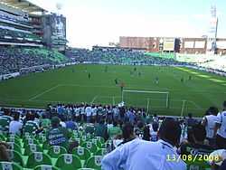
Torreón has a soccer team in the Primera División de México, Santos Laguna. The team won championships in 1996, 2001, 2008, and 2012. It used to play in Estadio Corona, but recently moved to the Territorio Santos Modelo to meet the growing demands of its fan base.
The city is also home to a baseball team called "Vaqueros Laguna" (Laguna Cowboys).
Torreón's professional basketball team, "Los Jefes", play in the Municipal Auditorium, which seats approximately 3,000 people. They are members of the LNBP (Liga Nacional de Balconcesto Profesional) which is considered to be the top basketball league in Mexico.
Former NFL placekicker and Super Bowl XXI champion, Raul Allegre, is a Torreón native.
Events
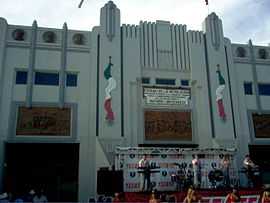
Cotton and Grape Fair
The main annual festival in Torreón is the Cotton and Grape Fair (Feria del Algodón y La Uva) which takes place in September. It contains cultural events, music, food and amusement rides.
"Paseo Colón" (Columbus Stroll)
It takes place every Sunday, at the "Calzada Colón" (Columbus Roadway) the street is closed an families get together to ride bikes, see the musical and cultural performances, walk their pets or just walk around.
Independence Day
It takes place on September 15 and 16. There are celebrations all around the city, but the most important is the one celebrated in the Plaza Mayor. People wear traditional mexican clothes, eat traditional dishes and "Antojitos". At night the city mayor makes the traditional celebration of "El Grito". The next day (September 16th) there is a parade on the Morelos Avenue
Twin towns
 Reynosa, Mexico
- Culiacan, Mexico
- Hermosillo, Mexico
- Chihuahua, Mexico
 São Paulo, Brazil
 Fresno, USA
- San Antonio, USA
- El Paso, USA
 Hamburg, Germany
Notable people
- Raúl Méndez, actor
- Pablo Montero, singer
- Carmen Salinas, actress
Gallery
|


Notes
- ↑ 1.0 1.1 "Coahuila de Zaragoza: Número de Habitantes" (in Spanish). Instituto Nacional de Estadística e Informática. Retrieved November 12, 2014.
- ↑ Jacques, Leo M. Dambourges (Autumn 1974). "The Chinese Massacre in Torreon (Coahuila) in 1911". Arizona and the West (University of Arizona Press) 16 (3): 233–246. Retrieved 4 December 2014 – via JSTOR. (subscription required (help)).
- ↑ "NORMALES CLIMATOLÓGICAS 1951–2010" (in Spanish). Servicio Meteorológico Nacional. Retrieved February 19, 2013.
- ↑ "NORMALES CLIMATOLÓGICAS 1981–2000" (PDF) (in Spanish). Comision Nacional Del Agua. Retrieved February 19, 2013.
- ↑ "Normales climatológicas para Torreon, Coah" (in Spanish). Colegio de Postgraduados. Retrieved February 19, 2013.
- ↑ Travel Torreón. "Cristo de las Noas". Retrieved 28 July 2010.
- ↑ "Cristo de las Noas". Archived from the original on August 14, 2007. Retrieved 2007-09-17.
References
- Link to tables of population data from Census of 2005 INEGI: Instituto Nacional de Estadística, Geografía e Informática
- Coahuila Enciclopedia de los Municipios de México
External links
- Ayuntamiento de Torreón Official website
- Economic Development Laguna de Coahuila Official website
- Google maps satellite photo of the city
