Tornado Alley
Tornado Alley is a colloquial term for the area of the United States where tornadoes are most frequent. The term was first used in 1952 as the title of a research project to study severe weather in parts of Texas, Oklahoma and Kansas only.[1]
Although the boundaries of Tornado Alley are not clearly defined, its core is northern Texas, Oklahoma, Kansas, and Nebraska.[2] Some research has indicated that tornadoes are becoming more frequent in the northern parts of Tornado Alley where it reaches the Canadian prairies.[3]
There is also a secondary tornado alley in Ontario, Canada, which runs from the Great Lakes region to the upper St. Lawrence valley.[4] It roughly follows the same route as Highway 401 from Windsor, Ontario to London, Ontario, with a secondary path from Lake Huron to Barrie, Ontario and across to Ottawa, Ontario. After the U.S., Canada gets the most tornadoes in the world, and a third of those tornadoes strike Southwestern Ontario.[5]
Tornado alley geographical area

Over the years, the location(s) of Tornado Alley have not been clearly defined. No definition of tornado alley has ever been designated by the National Weather Service.[6] Thus, differences of location are the result of the different criteria used.[6][7]
According to the National Severe Storms Laboratory FAQ,[6] "Tornado Alley" is a term used by the media as a reference to areas that have higher numbers of tornadoes. A study of 1921-1995 tornadoes concluded almost one-fourth of all significant tornadoes occur in this area.[8]
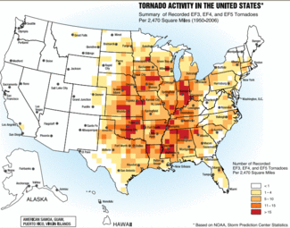
Though no state is entirely free of tornadoes, they occur more frequently in the Central United States, between the Rocky Mountains and Appalachian Mountains.[6] Texas reports the most tornadoes of any state due to its large size. Per square mile, Kansas and Oklahoma rank first and second respectively in the number of tornadoes. Florida also reports a high number and density of tornado occurrences, though tornadoes there rarely approach the strength of those that sometimes occur in the southern plains.[9] Regionally, the frequency of tornadoes in the United States is closely tied with the progression of the warm season when warm and cold air masses often clash.[9]
Another criterion for the location of Tornado Alley (or Tornado Alleys) can be where the strongest tornadoes occur more frequently.[10]
Tornado Alley can also be defined as an area reaching from central Texas to the Canadian prairies and from eastern Colorado to western Pennsylvania.[2]
It has also been asserted that there are numerous Tornado Alleys.[2] In addition to the Texas/Oklahoma/Kansas core, such areas include the Upper Midwest, the lower Ohio Valley, the Tennessee Valley and the lower Mississippi valley.[2] Some studies suggest that there are also smaller tornado alleys located across the United States.[11]
The tornado alleys in the southeastern U.S., notably the lower Mississippi Valley and the upper Tennessee Valley, are sometimes called by the nickname "Dixie Alley", coined in 1971 by Allen Pearson, former director of the National Severe Storms Forecasting Center.[12]
Another tornado alley has been identified in Ontario, Canada, running from the Great Lakes region to the upper St. Lawrence valley.[4] It roughly follows the same route as Highway 401 from Windsor, Ontario to London, Ontario, with a secondary path from Lake Huron to Barrie, Ontario and across to Ottawa, Ontario.[13]
Origination of the term
The term "tornado alley" was first used in 1952 by U.S. Air Force meteorologists Major Ernest J. Fawbush (1915–1982) and Captain Robert C. Miller (1920–1998) as the title of a research project to study severe weather in parts of Texas and Oklahoma.[14]
Impact
In the heart of tornado alley, building codes are often stricter than those for other parts of the U.S., requiring strengthened roofs and more secure connections between the building and its foundation. Other common precautionary measures include the construction of storm cellars, and the installation of tornado sirens. Tornado awareness and media weather coverage are also high.
The southeastern U.S. region is particularly prone to violent, long tracked tornadoes. Much of the housing in this region is less robust than in other parts of the USA and many people live in mobile homes. As a result, tornado related casualties in the southern U.S. are particularly high. One prime example was the April 25–28, 2011 tornado outbreak.
Average annual number of tornadoes per 10,000 square miles
These figures, reported by the National Climatic Data Center for the period between 1991 - 2010, show the seventeen U.S. states with the highest average tornadoes per 10,000 square miles.[15]
- Florida: 12.2
- Kansas: 11.7
- Maryland: 9.9
- South Carolina: 9
- Illinois: 9.7
- Mississippi: 9.2
- Iowa: 9.1
- Oklahoma: 9
- Alabama: 8.6
- Louisiana: 8.5
- Arkansas: 7.5
- Nebraska: 7.4
- Missouri: 6.5
- North Carolina: 6.4
- Tennessee: 6.2
- Texas: 5.9
- Minnesota: 5.7
Canadian tornadoes
After the U.S., Canada gets the most tornadoes in the world. The average number of tornadoes per 10,000 kilometres is highest in the southern parts of Alberta, Saskatchewan, and Manitoba, as well as Southern Ontario. Northern Ontario between the Manitoba border and the Lake Superior lakehead is also prone to severe tornadoes, but tornadoes in this area are believed to be underestimated due to the extremely low population in this region.[13][16]
Roughly half of all Canadian tornadoes strike the Canadian prairies and Northern Ontario as far east as Lake Superior. Together, these regions make up the northernmost border of the U.S. Tornado Alley. Tornadoes up to EF5 in strength have been documented in this region.[17]
Another third of Canadian tornadoes strike Southern Ontario, especially in the region halfway between the Great Lakes from Lake St. Clair to Ottawa, Ontario. This happens because tornadoes in this region are triggered or augmented by lake breeze fronts from Lake Huron, Lake Erie, Lake Ontario, and Georgian Bay. Tornadoes do not often hit lake shadow regions,[13] although they are not unknown, and some, such as the 2011 Goderich, Ontario tornado, have been violent. However, most Ontario tornadoes are concentrated in a narrow corridor from Windsor, Ontario and Sarnia, Ontario through London, Ontario, and then northeast to Barrie, Ontario and Ottawa, Ontario.[5] Tornadoes up to EF4 in strength have been documented in this region.
Southwestern Ontario weather is strongly influenced by its peninsular position between the Great Lakes. As a result, increases in temperature in this region are likely to increase the amount of precipitation in storms due to lake evaporation. Increased temperature contrasts may also increase the violence and possibly the number of tornadoes.[18]
See also
- List of tornadoes and tornado outbreaks
- Tornado climatology
- Hurricane Alley
- List of tornadoes by calendar day
References
- ↑ Tornado Alley Facts - Tornado Alley Facts
- ↑ 2.0 2.1 2.2 2.3 "Tornado Alley" (PDF). Smithsonian Institution. Retrieved 2013-10-02.
- ↑ http://www.usask.ca/water/news-and-events/news/news43.php
- ↑ 4.0 4.1 http://www.weather.com/blog/weather/8_12879.html
- ↑ 5.0 5.1 http://mobile.theweathernetwork.com/news/storm_watch_stories3&stormfile=Should__Tornado_Alley__be_expanded__11_04_2012?ref=ccbox_news_topstories
- ↑ 6.0 6.1 6.2 6.3 "Severe Weather 101: Tornado FAQ". National Severe Storms Laboratory. NOAA. January 29, 2007. Retrieved 2013-09-29.
- ↑ "Tornado FAQ". Storm Prediction Center. NOAA. January 29, 2007. Retrieved 2013-09-29.
- ↑ "Climatology Risk of Strong and Violent Tornadoes In the United States". Northern Illinois University & NOAA/ERL/National Severe Storms Laboratory. January 29, 2007. Retrieved 2007-04-26.
- ↑ 9.0 9.1 "Tornado Climatology". National Climatic Data Center. January 29, 2007. Retrieved 2007-04-26.
- ↑ "Tornado Activity in the United States: Summary of EF3, EF4, and EF5 tornadoes per 2,470 square miles". booklet FEMA 320, Taking Shelter from the Storm: Building a Safe Room Inside your House. Section 1, Figure 1.1, page 3: FEMA.gov. Archived from the original on ("Third edition".). Check date values in:
|archivedate=(help) - ↑ Broyles, Chris; C. Crosbie (October 2004). "Evidence of Smaller Tornado Alleys Across the United States Based on a Long Track F3-F5 Tornado Climatology Study from 1880-2003". 22nd Conference on Severe Local Storms. Hyannis, MA: American Meteorological Society.
- ↑ Gagan et al. (2010), page 147.
- ↑ 13.0 13.1 13.2 http://www.yorku.ca/pat/research/dsills/papers/GLOMW2012/Sills_GLOMW2012.pdf
- ↑ See:
- Jeremy Singer-Vine (May 23, 2011) "How did "Tornado Alley" get its name?," Slate (on-line magazine).
- John P. Gagan, Alan Gerard, and John Gordon (December 2010) "A historical and statistical comparison of "Tornado Alley" to "Dixie Alley", " National Weather Digest, vol. 34, no. 2, pages 146-155; see especially page 146.
- "Weather officers commended," Take-Off (newspaper of Tinker Air Force Base; Midwest City, Oklahoma), January 16, 1953.
- Results of search of Google Books for "tornado alley".
- ↑ "Average Annual Number of EF0-EF5 Tornadoes per 10,000 square miles during 1991 - 2010". National Climatic Data Center. U.S. Tornado Climatology: NOAA.gov. Archived from the original (GIF) on Updated 17 May 2013. Retrieved 26 October 2013. Check date values in:
|archivedate=(help) - ↑ http://www.accuweather.com/en/weather-blogs/anderson/when-is-peak-tornado-season-in-canada/31509
- ↑ http://ec.gc.ca/meteo-weather/default.asp?lang=En&n=6C5D4990-1#tornadoes
- ↑ http://www.sciences360.com/index.php/weather-predictions-made-by-the-global-warming-model-3254/