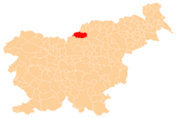
Topla, Črna na Koroškem
| Topla | |
|---|---|
 | |
_location_map.svg.png) Topla Location in Slovenia | |
| Coordinates: 46°29′9.18″N 14°45′51.78″E / 46.4858833°N 14.7643833°ECoordinates: 46°29′9.18″N 14°45′51.78″E / 46.4858833°N 14.7643833°E | |
| Country |
|
| Traditional region | Carinthia |
| Statistical region | Carinthia |
| Municipality | Črna na Koroškem |
| Area | |
| • Total | 13.43 km2 (5.19 sq mi) |
| Elevation | 1,084.5 m (3,558.1 ft) |
| Population (2002) | |
| • Total | 35 |
| [1] | |
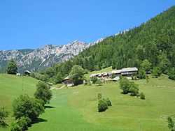
Topla (pronounced [ˈtoːpla]) is a dispersed settlement of isolated farmsteads in a valley with the same name at the foothills of Mount Peca west of Črna na Koroškem in the Carinthia region in northern Slovenia, close to the border with Austria.[2]
References
External links
| ||||||||||||||||||