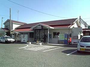
Tomioka Station
Tomioka Station 富岡駅 | |
 | |
|---|---|
| Tomioka Station in March 2009 | |
| Location | |
| Prefecture | Fukushima (See other stations in Fukushima) |
| District | Futaba |
| Town | Tomioka |
| Neighborhood etc. | Hotokehama Kamata 24 |
| (in Japanese) | 福島県双葉郡富岡町大字仏浜字釜田24 |
| History | |
| Year opened | 1898 |
| Rail services | |
| Operator(s) | JR East |
| Line(s) | Jōban Line |
| Statistics | 359 passengers/day (FY2010) |
.jpg)
Tomioka Station (富岡駅 Tomioka-eki) is a railway station operated by East Japan Railway Company in Tomioka, Fukushima, Japan.
Lines
Tomioka Station is served by the Jōban Line, and is located 247.0 kilometers from the official starting point of the line at Nippori Station. However, operations on the Jōban Line between Tatsuta Station and Nittaki Station are suspended indefinitely due Fukushima Daiichi nuclear disaster.
Station layout
Tomioka Station formerly had one island platform and one side platform, connected by a footbridge. The station building had a Midori no Madoguchi staffed ticket office.
Adjacent stations
| « | Service | » | ||
|---|---|---|---|---|
| Joban Line | ||||
| Rapid: no stop | ||||
| Tatsuta | Local | Yonomori | ||
History
Yonomori Station was opened on 23 August 1898. The station was absorbed into the JR East network upon the privatization of the Japanese National Railways (JNR) on 1 April 1987. The station was destroyed by the tsunami from the 11 March 2011 Tōhoku earthquake. In January 2015, work started on dismantling the remains of the station building and footbridge. [1]
Surrounding area
Tomioka is within the evacuation zone surrounding the Fukushima Daiichi Nuclear Power Plant. Since August 2012 it has been possible to enter the area, but remaining in the area overnight is prohibited due to high radiation levels.
- Tomioka Town Hall
- Tomioka Post Office
- Tomioka Fishing Port
- Japan National Route 6
References
- ↑ 津波と原発災害の象徴、富岡駅を解体 JR常磐線 (in Japanese). Asahi Shimbun . 25 January 2015.
External links
| Wikimedia Commons has media related to Tomioka Station. |
- JR East Station Information (Japanese)
| ||||||
Coordinates: 37°20′01″N 141°01′21″E / 37.3337°N 141.0224°E