Tokoroa
| Tokoroa, New Zealand | |
|---|---|
|
Tokoroa in autumn (May 2012) | |
 Tokoroa, New Zealand | |
| Coordinates: 38°14′S 175°52′E / 38.233°S 175.867°E | |
| Country | New Zealand |
| Region | Waikato |
| District | South Waikato district |
| Population (June 2014 estimate[1]) | |
| • Total | 13,550 |
.jpg)
Tokoroa (Maori: Te Kaokaoroa o Patetere) is the fifth-largest town in the Waikato region of the North Island of New Zealand and largest settlement in the South Waikato district. Located 30 km southwest of Rotorua, close to the foot of the Mamaku Ranges, it is mid-way between Taupo and Hamilton on State Highway One. Its 2006 census population was 13,600, a significant decline from the 2001 figure of 14,950.[2] Other notable South Waikato towns and settlements are Putaruru, Tirau and Arapuni.
History
Early History
It is traditionally recorded that one of the great fighting chiefs of the Ngati Kahupungapunga, Tokoroa by name, was slain by Ngati Raukawa during the siege of Pōhaturoa, a volcanic plug adjacent to Atiamuri, 27 km south of Tokoroa on the main Taupo highway. It is possible that some early surveyor applied the name Tokoroa as a tribute to the old chief's memory. The name Tokoroa first appeared on the early maps of the 1860s, although this was for an area 50 km north east of today's Tokoroa.
Foundations, Growth & Decline
Tokoroa is one of the most recent towns in New Zealand history. The township was established (circa) 1917 by the Matarawa Land Company as a potential farming area; although a few families had already settled in the area after 1910, and a school with 9 pupils was founded in 1915 (later to become Tokoroa East School).[3] The land was found to be poor for raising cattle or sheep due to its predominant pumice soils. However, agricultural science showed the land could actually be made to successfully support dairy cattle.[4] The soil had serious deficiencies causing livestock to ail from what became known as "bush sickness" (later found to be cobalt deficiency). In the 1930's, the deficiency was addressed, and subsequently, farming then became profitable.[5]
Between 1925 and 1935 Pinus Radiata was first introduced as a commercial tree crop, to the district - as the trees were found not to be adversely affected by the local soil deficiencies. As the initial crops matured, Tokoroa was then developed as a residential satellite for Kinleith Mill workers (New Zealand Forest Products Limited's integrated timber, pulp and paper mill), approximately 8 km's south of the township. In 1948, Tokoroa had a population of 1,100. In the ensuing years, and by the time NZFP (and later, mill-owner Carter Holt Harvey Ltd) began to downscale and restructure operations at Kinleith in the 1980's, Tokoroa had a population of approximately 18,000 – just 2,000 below the number necessary to be officially deemed, by new Zealand standards, a city. In the early 1970's, however, Tokoroa did in fact, for a time, reach a population of over 20,000. Since the late 1980's however, ongoing downscaling at Kinleith - and closing of other local industries - has resulted in a marked drop in population; census figures put the 2006 population at approximately 13,600.
Geography
Location
Surrounding the township are many dairy farms and plantation forests. There are many scenic reserves around the town – the artificial lake 'Moana-Nui' (formed by damming the Matarawa Stream) lies within a popular recreational park.
The town's location in the central North Island and its developed transportation network provide plenty of potential for warehousing and distribution. Tokoroa lies in the centre of a triangle made up of the popular tourism destinations of Rotorua, Waitomo and Taupo. There are also some forty-five, popular recreational lakes within less than an hour's drive of Tokoroa.
One can travel to four major centres, also each less than an hour's drivefrom the township:
Township
As well as the central business district, the township is made up of many subdivisions, each built in different stages of the Kinleith complex's development. These subdivisions are:
- Parkdale
- Paraonui
- Papanui
- Matarawa
- Aotea
- Strathmore
- Amisfield
Many of the street names of the town were named by the first managing director of N.Z. Forest Products Ltd.(builders of the Kinleith mill), Sir David Henry (1888–1963), after places near his home town of Edinburgh, in Scotland. David Henry Primary School is a key example of him and his namesaking.
Demographics
Tokoroa is a town of over 13,600 people, with around 1.5 million people – 40% of New Zealand's total population – living within a 250 km (155 mi) radius.
Tokoroa is a multicultural town, with about 35% of the population being Maori and another 20% from the Pacific Islands (mainly the Cook Islands). The remaining 45% of the population is made up mainly by NZ Europeans. Tokoroa has New Zealand's largest Pacific Island community outside of Auckland and Wellington.
Changing Economy
The economic lifeblood of Tokoroa is forestry, centred at the nearby Kinleith Mill; and dairy farming. In 1995, Fonterra built the southern hemisphere's largest cheese factory in Lichfield,[6] some 5 km north of the town. Recently, due to an increase in dairy prices, large amounts of previously forested land are in the process of being converted into farmland.
The main rural activities of the district are sheep and dairying. Forestry is still, however, the primary and most important industry to the district. Timber is milled and processed at Kinleith. Over recent years, the sharp decline in timber processing has seen the majority of raw logs shipped offshore. Most of the Kinleith workers live in Tokoroa, with a small number commuting from other South Waikato towns. Tokoroa is a marketing and servicing centre for agriculture, inline with other associated industries. These other industries include (but are not limited to): the manufacture of cheese (and related dairy products [via Fonterra]), specialised wooden boxing, timber joinery, sawmilling, general engineering, and the quarrying of building (masonry) stone.
Although Tokoroa's economy primarily tends to revolve around timber and farming, many large retail companies have continued investing in the town – Foodstuffs recently constructed and opened a New World (supermarket) on Tokoroa's main street (Bridge Street). Also, Progressive Enterprises (a major competitor to Foodstuffs Group) also recently built New Zealand's first Countdown (supermarket) featuring bilingual (i.e. including Te Reo-Maori) signage.
Education
Tertiary education is important to Tokoroa, through Te Wānanga o Aotearoa and Waiariki Institute of Technology. As well as several primary, an intermediate, and two high schools, it also notably boasts a Te Kura Kaupapa Māori primary school offering education in the Te reo Māori language.
Tertiary education
- Waiariki Institute of Technology (satellite campus)
- Te Wananga o Aotearoa
Secondary schools
- Forest View High School
- Tokoroa High School
Alternative Education (for Secondary students who work better with full teacher guidance, non-classroom)
- Forest View High School Alternative Education – Tautoko Kura
Intermediate schools
- Tokoroa Intermediate School
- Tainui Full Primary school
- Amisfield Full Primary School
- Te Kura Kaupapa Maori o Te Hiringa
Primary schools
- Tokoroa East School, State Highway 1, Tokoroa [discontinued & closed, 2011[7]]
- David Henry School, Tokoroa
- Strathmore School, Tokoroa
- Tokoroa North School, Tokoroa
- Bishop Edward Gaines Primary School, Tokoroa (under the auspices of: St. Pius X, Catholic Church)
- Tokoroa Central School, Tokoroa
- Cargill Open Plan School, Tokoroa
- Tainui Full Primary School, Tokoroa
- Te Kura Kaupapa Maori o Te Hiringa
- Matarawa Primary School [discontinued & closed, 1999]
Kindergartens
- Te Kohanga Reo
- Clyde Street Kindergarten
- Taumafai Aoga Amata – Samoan Hall
- Balmoral Kindergarten
- Paraonui Kindergarten
- Te Awhi Man Kohanga Reo
- Ata Marie Kohanga Reo
- Arohanui Kindergarten
- Zuzus Young Explorers Centre
- David Henry Kindergarten
- Te Ara Metua Punaga Reo Kindergarten
- Raitu Punanga Reo
- St. Lukes P.I.P.C Punanga Reo
Town facilities and attractions
Tokoroa has a number of Tourist and visiting attractions, as well as many facilities for local use.
Talking Poles
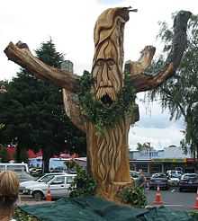
Since 1997, Tokoroa has been "sprouting" Talking Poles, consisting mainly of carvings representing ethnic culture, sport recreation, industry in the town and stories about the town. This one, photographed shortly after its unveiling in 2004, is a chainsaw carving of a deodar cedar which died from natural causes. It is representative of the Greenman in Welsh mythology and is located on State Highway 1, immediately adjacent to the town's information centre.
As at October 2008, 42 Talking Poles are displayed around the town. Tokoroa Talking Poles symposium is convened every two years at the Tokoroa campus of Te Wananga o Aotearoa. The Greenman was carved in 2004 by Mr. Andy Hankcock.[8]
Lake Moana-Nui
Tokoroa's man-made Lake Moana-Nui was created in the late 1970s for the community, involving excavatation by large earthmoving equipment and a concrete dam-wall with a drain valve control. A wooden bridge located on the south west end of the dam wall that supported and controlled the drain valve, was a favourite 'bomb' spot and bare foot skiing down the spillway was an early extreme sport unique to Tokoroa. During the 1970s 'The Lake' was used extensively by youths and was referred to in local parlance as 'Tokoroa Beach'. On many summer afternoons it was a common sight to see youth lying on the footpath across the road from the lake drying out after a swim.
In the period following the initial construction dam in the late 1970s, the lake began to detriorate due to low rainfall and poor water flows, which saw lake weed overtake the swimming areas. The lake weed eventually became a drowning hazard that claimed the lives of some young people over the preceding decade. In this sense the project was a failure and lake Moana-Nui is now considered unsafe. In an effort to control the problems, signs were erected banning access to the dam wall, and basic handrailing was put up to prevent public access. The lake was subject to regular draining in an effort to control the weed and to flush out the stale, stagnant water. While this did slightly improve the situation in the short term, people were warned not to swim in it. The lake is undergoing a major cleaning project so that it can be used in the future.[9] To date (25 April, 2015), Lake Moana-Nui has been fully, drained, refilled, and restored - and has been cleared by the local council for public recreation as it was in its heyday during the 1970's and 80's.
There are picnic tables built around the lakes arc and there are four playgrounds. At the southern end of Lake Moana-Nui are gardens which were planted by a collective of Tokoroa school children.
Town Library
The current location of Tokoroa's library holds many historic memories for the locals - as it was previously the town's cinema. It currently holds a library with a full computer suite, over 2000 books, a reference book section, and children's leisure area. It is located in the Tokoroa town centre.
Tokoroa Hospital
Tokoroa Hospital provides limited medical services for a population of approximately 22,800 people in the South Waikato District. Currently the hospital provides 21 beds made up of a 17-bed inpatient ward and a 4-bed maternity ward. There is also a dedicated emergency department with capacity for five patients, and a fully functional theatre suite presently used for minor day surgery. Other facilities include x-ray and laboratory services, a cafe, a helipad for patient transfer, and various allied health services. District health and public health nurses, diabetes nurse specialists, an occupational therapist, a physiotherapist, and a social worker are based at the hospital site, which also accommodates the Tokoroa Council of Social Services (a local umbrella organisation for various community services). Various clinics with visiting specialists are held at the hospital.[10]
Culture and sports
Tokoroa hosts a number of sporting, cultural and music events every year including the Polynesian festival.
Polynesian Festival
Tokoroa Polynesian Festival occurs every year during September. Tokoroa's local schools and preschools give Samoan, Maori and Cook Islands performances, where you hear the Cook Island drumming and dancing and the Maori performance being displayed on the huge stage at the new South Waikato Events Centre, located at The Tokoroa Memorial Sports Ground. 2009 host was NZ artist J.Williams and Erika.
Sports
Tokoroa being within the Waikato Province, falls under the Waikato ITM Cup provincial catchment, and the Chiefs Super Rugby franchise. The South Waikato district's netball associations also fall under the catchment for inclusion in the ANZ Championship, Waikato/BOP Magic franchise.
Over many decades, Tokoroa has been a natural base for strong, competitive woodchopping and sawing events. The axe, long-saw and chainsaw competitions, at the local A&P Shows, over many decades, have always been central to the local, timber and timber-works culture of the town.
Tokoroa Memorial Sports Ground
The sports ground is used every weekend and is in use throughout the week-days. The Memorial Sports Ground comprises –
- Eight full netball courts
- Eight full tennis courts
- Three full rugby fields
- Eight touch or rugby league fields
- One Soccer field
- One Rugby Union Club - Southern United Rugby Football Club (SURF)
Also, South Waikato District Council is building a new South Waikato Event Centre that will feature a gymnasium, performing arts stage, meeting room, and changing rooms. (Note: The South Waikato Events Centre has sinced opened, and was dedicated in late 2012.)
Y.M.C.A sports centre
Tokoroa's Y.M.C.A hosts a number of indoor and outdoor events, such as :
- Indoor skating
- Outdoor Archery
- Indoor and outdoor soccer
- Basketball
- Netball
- Indoor hockey
- Dance classes
The centre has recently undergone a major upgrade, including heat pumps, which heat up the whole stadium. New stadium lights were installed by a local Tokoroa company.
Transportation
Cycling
Tokoroa has extensive cycleways which link the town centre with the outlying suburbs. These cycleways consist of a mixture of dedicated cycle lanes and mixed use cycle/walk ways. There is an extensive cycleway from Browning Street, Tokoroa that leads to Kinleth which features spectacular views of the town and the Kinleith mill.
Road
Private cars are the transport medium of choice in this spread-out town. Walking has been gaining in popularity in recent years, however the relative lack of congestion compared to other towns and ample availability of parking results in private car use being the main mode of transport.
New Zealand's main road artery State Highway 1 runs through Tokoroa's eastern suburbs. The speed limit through the northern end of State Highway 1 is 60 km/h and the southern end of State Highway 1 is 80 km/h. Tokoroa is also accessible from the south-west via State Highway 32. Tokoroa is a non-traffic light town.
Tokoroa is served by bus services such as Intercity Coachlines and Naked Bus operating on routes along State Highway 1.
Railway
The Kinleith Branch line runs through Tokoroa on its route between Waharoa on the East Coast Main Trunk line, and its terminus at the Kinleith mill to the south of the town. Most freight trains on the line travel between the Kinleith mill and the Port of Tauranga. There has never been any passenger services on the line. There is no longer a station or rail freight yard in Tokoroa.
Previous to the construction of the Kinleith mill and the current Kinleith Branch line, a private bush tramway operated by the Taupo Totara Timber Company, used to operate along the route of the present line along its length between Putaruru and the company's mill at Mokai, near Taupo.
The main cargo, from Kinleith, used to include: raw and processed pulp; paper products; plywood, timber, and raw logs. With restructuring having taken its toll on processing at Kinleith, however, the predominant cargo is raw and ring-barked logs, for export to processing plants world-wide.
Radio stations
There are several local radio stations in Tokoroa:
- Raukawa FM 90.9/95.7 MHz
- Cruise FM, locally owned community radio station broadcasting to Tokoroa 94.1FM, Mangakino-Whakamaru 104.4FM and Putaruru 107.7FM. Ph 07 88 66 939 94.1 MHz
- Vision FM 88.5 MHz
As well as local repeaters of national radio stations:
- Radio New Zealand National 729 kHz/101.3 MHz
- Newstalk ZB 1413 kHz
- Radio Rhema 99.7 MHz
- The Hits 97.3 MHz
Notable People
- Isaac Boss — Ireland rugby union International
- Pero Cameron — basketball player NZ Basketball rep' (Honours: Auckland and Waikato NBL Teams; Coach of Wellington Saints NBL Championship Team, 2010; NZ Tall Blacks)
- Adrian Cashmore – rugby union player (honours: Auckland, Auckland Blues, NZ All Blacks)
- Quade Cooper – Australian rugby union player (honours: Queeensland Reds, Wallabies)
- John Davies – teacher, public relations man, Bronze medal-winning athlete (1964 Summer Olympics), and athletics coach
- Stella Duffy – Novelist
- Nick Franklin – FMX Rider
- Ben Hana – Wellington identity: better known as "Blanket Man" (deceased)
- Tommy Hayes – Cook Islands rugby union representative
- Isaac John – rugby league player: (honours: NZ Warriors, Wakefield Trinity [UK], Penrith Panthers, Cook Islands Rugby League, New Zealand Kiwis)
- Richard Kahui – Waikato rugby union player, (honours: Waikato RFC, Highlanders, Chiefs, All Black
- Nicky Little – International honours: Fiji Rugby Union representative (nephew of Walter Little)
- Walter Little (honours: North Harbour RFC, Waikato/BOP Chiefs, Auckland Blues, NZ All Black's)
- Kendrick Lynn – rugby union player
- Sean Maitland – Scotland International, (honours: Glasgow Warriors, former Canturbury Crusaders, NZ U-20 Rugby Union Team - which won the U-20 World Cup)
- Keven Mealamu — (honours: Auckland RFC, Auckland Blues, NZ All Black's)
- Jenny Morris – New Zealand/Australian singer/songwriter, The Crocodiles; Models and INXS
- Henry Paul – New Zealand (Kiwis) rugby league representative
- Robbie Paul – New Zealand (Kiwis) rugby league representative
- The Politicians – rock/new wave/reggae band formed in 1981
- Sir Paul Reeves – Anglican priest, Archbishop / diplomat / former Governor-General of New Zealand
- Bruce Simpson – blogger and jet-engine experimenter
- Brian Tamaki – founder of Destiny Church
- Zane Tetevano – honours: Newcastle Knights RL (2011), Cook Islands Rugby league Representative
- Maria Tutaia – New Zealand netball representative (honours: Waikato/BOP Magic, Northern Mystics, Silver Ferns)
- Monique Williams – New Zealand sprinter (honours: selection at NZ representative levels)
- Royce Willis – rugby union player (honours: BOP RFC, Waikato RFC, Auckland Blues, Waikato/BOP Chiefs, NZ All Blacks [12 Tests])
Notes and references
- ↑ "Subnational Population Estimates: At 30 June 2014 (provisional)". Statistics New Zealand. 22 October 2014. Retrieved 2 November 2014. Also "Infoshare; Group: Population Estimates - DPE; Table: Estimated Resident Population for Urban Areas, at 30 June (1996+) (Annual-Jun)". Statistics New Zealand. 22 October 2014. Retrieved 2 November 2014.
- ↑ "Subnational Population Estimates" (PDF). New Zealand Department of Statistics. 20 October 2006. p. 16.
- ↑ "History of Tokoroa". Tokoroa Intermediate. Retrieved 25 February 2014.
- ↑ "Pumice Lands Proved". Ohinemuri Gazette. XXXII (4228). 14 February 1921. p. 2.
- ↑ Swarbrick, Nancy (13 July 2012). "Waikato Places - Tokoroa". Te Ara - The Encyclopedia of New Zealand.
- ↑ "Fonterra Cheese Factory". South Waikato District Council. Retrieved 2010-01-16.
- ↑ http://tokoroaeastschool-jay.weebly.com/home.html
- ↑ "Chainsaw man".
- ↑ "Lake Maona Nui".
- ↑ "Waikato District Health Board".
- Reed, A. W. (2002). The Reed Dictionary of New Zealand Place Names. Auckland: Reed Books. ISBN 0-7900-0761-4.
External links
- South Waikato district council website
- South Waikato Information
- Fast Forward South Waikato
- Tokoroa Information resource
| ||||||||||||||||||||||