Tivetshall St Mary
| Tivetshall St Mary | |
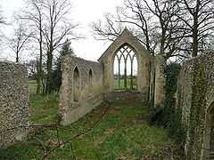 Ruins of Tivetshall St. Mary church |
|
 Tivetshall St Mary |
|
| Area | 4.65 km2 (1.80 sq mi) |
|---|---|
| Population | 302 |
| – density | 65/km2 (170/sq mi) |
| OS grid reference | TM169859 |
| Civil parish | Tivetshall St. Mary |
| District | South Norfolk |
| Shire county | Norfolk |
| Region | East |
| Country | England |
| Sovereign state | United Kingdom |
| Post town | NORWICH |
| Postcode district | NR15 |
| Police | Norfolk |
| Fire | Norfolk |
| Ambulance | East of England |
| EU Parliament | East of England |
Coordinates: 52°25′43″N 1°11′20″E / 52.42872°N 1.18898°E
Tivetshall St Mary is a civil parish in the district of South Norfolk and county of Norfolk, England. It covers an area of 4.65 km2 (1.80 sq mi) and had a population of 302 in 117 households at the 2001 census.[1] For the purposes of local government, it falls within the district of South Norfolk.
Notes
- ↑ "Tivetshall St Mary parish information". South Norfolk Council. 19 May 2008. Retrieved 20 June 2009.
External links
![]() Media related to Tivetshall St Mary at Wikimedia Commons
Media related to Tivetshall St Mary at Wikimedia Commons