Tinhosa Pequena
|
Map of São Tomé and Príncipe with Tinhosa Pequena on the top | |
| Geography | |
|---|---|
| Location | São Tomé and Príncipe, northeast of the island of São Tomé Island and about 20 km (12 mi) SW of Príncipe Island |
| Coordinates | 1°24′26″N 7°16′25″E / 1.4071°N 7.2736°ECoordinates: 1°24′26″N 7°16′25″E / 1.4071°N 7.2736°E |
| Area | 1 km2 (0.39 sq mi) (approx.) |
| Highest elevation | 75 m (246 ft) (approx. 50 to 100 m) |
| Country | |
| Demographics | |
| Population | 0 |
| Density | 0 /km2 (0 /sq mi) |
| Additional information | |
| Stratovolcano | |
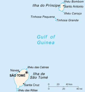
Tinhosa Pequena is an islet in São Tomé and Príncipe located northeast of the main island of São Tomé and approximately 20 km (12 mi) southwest of the island of Príncipe. The islet is north of the nearby larger islet named Tinhosa Grande.
Geography
The islet contains dry grasslands and rock ledges that elevate up to 40 m (130 ft).
Panorama
The islet can definitely be seen from the southwestern part of Príncipe Island and can rarely be seen from São Tomé Island.
Nearest islands and islets
- Príncipe, approximately 20 km (12 mi) northeast
- Tinhosa Grande, south
- São Tomé, approximately 100 km (62 mi) southwest
References
| ||||||||||