Timpanogos Glacier
| Timpanogos Glacier | |
|---|---|
|
Emerald Lake below the glacier, the bugle in the talus is where the glacier is buried. | |
 Timpanogos Glacier Location in Utah | |
| Type | Rock Glacier |
| Location | Utah County, Utah, U.S. |
| Coordinates | 40°21′59″N 111°37′13″W / 40.36639°N 111.62028°WCoordinates: 40°21′59″N 111°37′13″W / 40.36639°N 111.62028°W[1] |
| Thickness | 40+ feet? |
| Terminus | proglacial lake |
| Status | Buried |
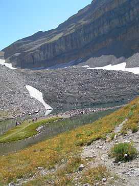
Timpanogos Glacier is a buried glacier that is located in the Wasatch Range, Wasatch-Cache National Forest, and is the last glacier in the U.S. state of Utah. The glacier is situated on the north slope of Mount Timpanogos (11,749 feet (3,581 m)).[2] During the dust bowl drought of the 1930s, the above-ground portion of the glacier was reduced to a permanent snowfield. The glacier is now considered to be a rock glacier, since the remaining ice is now buried in the talus. In 1994, the rocks parted, revealing a crevasse in the buried glacier. One witness described it as being "40 feet thick at least" [3] Emerald Lake is a small proglacial lake which lies at the terminal moraine left behind by the now mostly vanished Timpanogos Glacier. The blue color of Emerald Lake is an indicator of the buried glacial ice.
See also
References
- ↑ "Timpanogos Glacier". Geographic Names Information System. United States Geological Survey. Retrieved 2012-09-02.
- ↑ Aspen Grove, UT (Map). TopoQwest (United States Geological Survey Maps). Retrieved 2012-09-2. Check date values in:
|accessdate=(help) - ↑ "100 Years on the Timpanogos Glacier". SummitPost. Retrieved 2012-09-02.