Timeline of the 2009 Atlantic hurricane season

The 2009 Atlantic hurricane season was a below-average year in which nine tropical storms formed, the fewest since 1997.[nb 1][1] Although Tropical Depression One formed on May 28, 2009, the season officially began on June 1 and ended on November 30.[2][3] The season's last storm, Hurricane Ida, dissipated on November 11.[4]
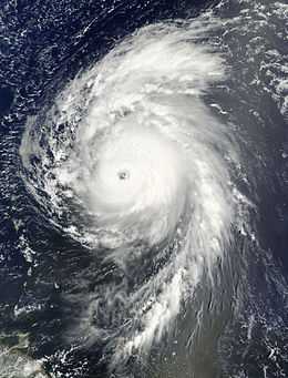
The season had eleven tropical depressions, of which nine intensified into tropical storms, three became hurricanes, and two became major hurricanes.[nb 2] The inactivity throughout the basin was linked to the formation of an El Niño, which increased wind shear.[1] The two most significant storms of the season, in terms of loss of life and damage, were Hurricanes Bill and Ida. Hurricane Bill was an unusually large storm and was also the season's strongest, attaining winds of 135 mph (215 km/h).[5] Tropical Storm Claudette was the only storm during 2009 to make landfall in the United States; Hurricane Ida became extratropical shortly before coming ashore in Alabama.
This timeline includes information that was not operationally released, meaning that information from post-storm reviews by the National Hurricane Center, such as a storm that was not operationally warned upon, has been included. This timeline documents tropical cyclone formations, strengthening, weakening, landfalls, extratropical transitions, and dissipations during the season.
Timeline of events

May

- May 28
- 1 a.m. EDT (0600 UTC) – Tropical Depression One develops from an area of low pressure roughly 175 mi (280 km)[nb 3] east-northeast of Cape Hatteras, North Carolina.[3]
- 1 p.m. EDT (1800 UTC) – Tropical Depression One attains its peak intensity with winds of 35 mph (55 km/h) and a barometric pressure of 1006 mbar (hPa; 29.71 inHg).[3]
- May 29
- 7 p.m. EDT (0000 UTC on May 30) – Tropical Depression One degenerates into a non-convective remnant low pressure area roughly 345 mi (555 km) south-southeast of Halifax, Nova Scotia.[3]
June
- No tropical cyclones formed during the month of June.[6]
- June 1
- 12 a.m. EDT (0400 UTC) – The 2009 Atlantic hurricane season officially begins.[7]
July
- No tropical cyclones formed during the month of July, making the 2009 season one of fourteen since 1944 in which no tropical storms developed during June and July.[8]
August
- August 11
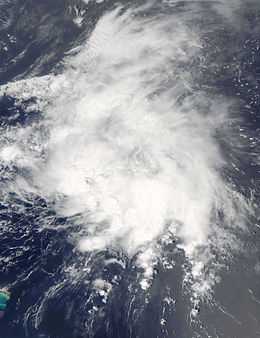
- 2:00 a.m. AST (0600 UTC) – Tropical Depression Two develops from a tropical wave roughly 230 mi (370 km) west of the Cape Verde Islands.[9]
- August 12
- 8:00 a.m. AST (1200 UTC) – Post-season research indicated that at this time, Tropical Depression Two attained tropical storm status. However, as it was not operationally recognized as such, it was not named.[9]
- 8:00 p.m. AST (0000 UTC on August 13) – Tropical Storm Ana weakens into a tropical depression.[9]
- August 13
- 2:00 a.m. AST (0600 UTC) – Tropical Depression Two degenerates into an non-convective remnant low about 775 mi (1,250 km) west of the Cape Verde Islands.[9]
- August 14
- 8:00 p.m. AST (0000 UTC on August 15) – The remnants of Tropical Depression Two regenerate into a tropical depression roughly 1,075 mi (1,730 km) east of the Lesser Antilles.[9]
- August 15
- 2:00 a.m. AST (0600 UTC) – Tropical Depression Two strengthens into Tropical Storm Ana. The storm also attains its peak intensity with winds of 40 mph (65 km/h) and a minimum pressure of 1003 mbar (hPa; 29.62 inHg).[9]
- 2:00 a.m. AST (0600 UTC) – Tropical Depression Three forms out of a tropical wave roughly 380 mi (610 km) west-southwest of the Cape Verde islands.[5]
- 2:00 p.m. AST (1800 UTC) – Tropical Depression Three strengthens into Tropical Storm Bill.[5]
- August 16
- 1:00 a.m. EDT (0600 UTC) – Tropical Depression Four develops over the eastern Gulf of Mexico, roughly 60 mi (95 km) west-southwest of Sarasota, Florida.[10]
- 7:00 a.m. EDT (1200 UTC) – Tropical Depression Four strengthens into Tropical Storm Claudette.[10]
- 8:00 a.m. AST (1200 UTC) – Tropical Storm Ana weakens into a tropical depression shortly before degenerating into a trough of low pressure roughly 400 mi (645 km) east of the Lesser Antilles.[9]
- 1:00 p.m. EDT (1800 UTC) – Tropical Storm Claudette attains its peak winds of 60 mph (95 km/h) while situated roughly 40 mi (65 km) south of Apalachicola, Florida.[10]
- 7:00 p.m. EDT (0000 UTC on August 17) – Tropical Storm Claudette attains its minimum pressure of 1005 mbar (hPa; 29.68 inHg) just off the Florida coastline.[10]
- August 17
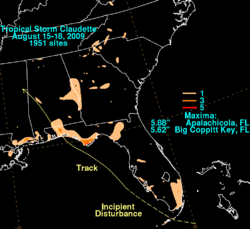
- 12:30 a.m. EDT (0530 UTC) – Tropical Storm Claudette makes landfall near Fort Walton Beach, Florida with winds of 45 mph (75 km/h).[10]
- 2:00 a.m. AST (0600 UTC) – Tropical Storm Bill strengthens into a Category 1 hurricane midway between the Lesser Antilles and the Cape Verde Islands.[5]
- 7:00 a.m. EDT (1200 UTC) – Tropical Storm Claudette weakens to a tropical depression over Alabama.[10]
- 7:00 p.m. EDT (0000 UTC on August 18) – Tropical Depression Claudette dissipates over eastern Mississippi.[10]
- 8:00 p.m. AST (0000 UTC on August 18) – Hurricane Bill strengthens to a Category 2 hurricane.[5]
- August 18
- 2:00 p.m. AST (1800 UTC) – Hurricane Bill strengthens into a major hurricane—a storm with winds of 111 mph (178 km/h) or higher.[5]
- August 19
- 2:00 a.m. AST (0600 UTC) – Hurricane Bill strengthens to a Category 4 hurricane, attaining its peak winds of 135 mph (215 km/h).[5]
- August 20
- 8:00 a.m. AST (1200 UTC) – Hurricane Bill weakens to a Category 3 hurricane.[5]
- 8:00 a.m. AST (0000 UTC on August 21) – Hurricane Bill attains its secondary peak intensity with winds of 125 mph (205 km/h) and a minimum pressure of 943 mbar (hPa; 27.84 inHg), the lowest pressure recorded in any storm during the 2009 season.[5]
- August 21
- 2:00 p.m. AST (1800 UTC) – Hurricane Bill weakens to a Category 2 hurricane.[5]
- August 22
- 2:00 a.m. AST (0600 UTC) – Hurricane Bill makes its closest approach to Bermuda, passing roughly 175 mi (280 km) west of the island with winds of 105 mph (165 km/h).[5]
- 2:00 p.m. AST (1800 UTC) – Hurricane Bill weakens to a Category 1 hurricane.[5]
- August 23
- 2:00 p.m. AST (1800 UTC) – Hurricane Bill brushes the coastline of Nova Scotia with winds of 80 mph (130 km/h).[5]
- 10:00 p.m. AST (0200 UTC on August 24) – Hurricane Bill weakens to a tropical storm just off the southern coast of Newfoundland
- 11:00 a.m. AST (0300 UTC) – Tropical Storm Bill makes landfall at Point Rosie on the Burin Peninsula of Newfoundland with winds of 70 mph (110 km/h).[5]
- August 24
- 8:00 a.m. AST (1200 UTC) – Tropical Storm Bill transitions into an extratropical cyclone over the north Atlantic Ocean as it rapidly tracks eastward towards the United Kingdom.[5]
- August 26
- 4:00 a.m. EDT (0900 UTC) – Tropical Storm Danny develops from a disorganized area of low pressure roughly 495 mi (795 km) east of Nassau, Bahamas.[11]
- 7:00 p.m. EDT (0000 UTC on August 27) – Tropical Storm Danny attains its peak intensity with winds of 60 mph (95 km/h) and a minimum pressure of 1006 mbar (hPa; 29.71 inHg).[11]
- August 29
- 1:00 a.m. EDT (0600 UTC) – Tropical Storm Danny degenerates into a trough of low pressure shortly before being absorbed by a larger low pressure system.[11]
September
- September 1
- 2:00 p.m. AST (1800 UTC) – Tropical Storm Erika forms roughly 290 mi (465 km) east of Guadeloupe.[12]
- 8:00 p.m. AST (0000 UTC on September 2) – Tropical Storm Erika attains its peak intensity with winds of 50 mph (85 km/h) and a minimum pressure of 1004 mbar (hPa; 29.65 inHg).[12]
- September 2
- 2:30 p.m. AST (1830 UTC) – Tropical Storm Erika passes over the island of Guadeloupe with winds of 40 mph (65 km/h).[12]
- September 3
- 2:00 p.m. AST (1800 UTC) – Tropical Storm Erika weakens to a tropical depression.[12]
- 8:00 p.m. AST (0000 UTC on September 4) – Tropical Depression Erika degenerates into a non-covective remnant low over the eastern Caribbean Sea.[12]
- September 7
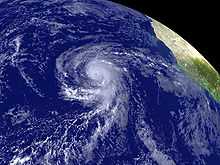
- 2:00 p.m. AST (1800 UTC) – Tropical Depression Seven develops out of an area of low pressure roughly 220 mi (355 km) south of Brava, Cape Verde.[13]
- 8:00 p.m. AST (0000 UTC on September 8) – Tropical Depression Seven intensifies into Tropical Storm Fred.[13]
- September 8
- 8:00 p.m. AST (0000 UTC on September 9) – Tropical Storm Fred intensifies into a hurricane, the second of the season.[13]
- September 9
- 2:00 a.m. AST (0600 UTC) – Hurricane Fred intensifies into a Category 2 hurricane.[13]
- 8:00 a.m. AST (1200 UTC) – Hurricane Fred further intensifies into a Category 3 hurricane and attains its peak intensity with winds of 120 mph (195 km/h) and a minimum pressure of 958 mbar (hPa; 28.29 inHg), becoming the strongest known hurricane on record south of 30°N and east of 35°W.[13]
- 8:00 p.m. AST (0000 UTC on September 10) – Hurricane Fred weakens to a Category 2 hurricane.[13]
- September 10
- 2:00 p.m. AST (1800 UTC) – Hurricane Fred weakens to a Category 1 hurricane.[13]
- September 11
- 2:00 p.m. AST (1800 UTC) – Hurricane Fred weakens to a tropical storm as it stalls northwest of the Cape Verde Islands.[13]
- September 12
- 2:00 p.m. AST (1800 UTC) – Tropical Storm Fred degenerates into a non-convective remnant low roughly 570 mi (920 km) west of Santo Antão, Cape Verde. The remnants of Fred would persist for nearly a week before fully dissipating south of Bermuda on September 19.[13]
- September 25
- 2:00 p.m. AST (1800 UTC) – Tropical Depression Eight forms roughly 225 mi (360 km) southwest of the Cape Verde Islands.[14]
- September 26
- 2:00 p.m. AST (1800 UTC) – Tropical Depression Eight degenerates into a remnant low west of the Cape Verde Islands.[14]
October
- October 4
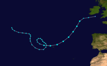
- 2:00 a.m. AST (0600 UTC) – Tropical Storm Grace forms out of an extratropical system roughly 135 mi (225 km) west of Lajes, Azores, becoming the northeasternmost forming cyclone in the Atlantic on record.[15]
- 8:00 p.m. AST (0000 UTC on October 5) – Tropical Storm Grace attains its peak winds of 65 mph (100 km/h).[15]
- October 5
- 2:00 p.m. AST (1800 UTC) – Tropical Storm Grace attains its minimum pressure of 986 mbar (hPa; 29.11 inHg).[15]
- 8:00 p.m. AST (0000 UTC on October 6) – The tenth tropical depression of the season forms roughly 775 mi (1,250 km) east of the Lesser Antilles.[16]
- October 6
- 2:00 a.m. AST (0600 UTC) – Tropical Storm Grace transitions into an extratropical cyclone roughly 230 mi (370 km) west-southwest of Cork, Ireland.[15]
- 2:00 a.m. AST (0600 UTC) – The tropical depression east of the Lesser Antilles strengthens into Tropical Storm Henri.[16]
- October 7
- 2:00 a.m. AST (0600 UTC) – Tropical Storm Henri attains its peak intensity with winds of 50 mph (85 km/h) and a minimum pressure of 1005 mbar (hPa; 29.68 inHg).[16]
- October 8
- 2:00 a.m. AST (0600 UTC) – Tropical Storm Henri weakens to a tropical depression.[16]
- 2:00 p.m. AST (1800 UTC) – Tropical Depression Henri degenerates into a remnant low roughly 155 mi (250 km) north of Anguilla.[16]
November
- November 4
- 12:00 a.m. CDT (0600 UTC) – Tropical Depression Eleven forms over the southwestern Caribbean Sea near San Andres Island.[4]
- 6:00 a.m. CDT (1200 UTC) – Tropical Depression Eleven intensifies into Tropical Storm Ida.[4]
- November 5

- 12:00 a.m. CDT (0600 UTC) – Tropical Storm Ida strengthens into a Category 1 hurricane as it passes near the Corn Islands with winds of 75 mph (120 km/h).[4]
- 6:00 a.m. CDT (1200 UTC) – Hurricane Ida makes landfall near Rio Grande, Nicaragua with winds of 80 mph (130 km/h).[4]
- 12:00 p.m. CDT (1800 UTC) – Hurricane Ida weakens into a tropical storm over the high terrain of Nicaragua.[4]
- November 6
- 12:00 a.m. CDT (0600 UTC) – Tropical Storm Ida further weakens to a tropical depression as it nears Honduras.[4]
- November 7
- 12:00 a.m. CDT (0600 UTC) – Tropical Depression Ida restrengthens into a tropical storm after moving over the warm waters of the northwestern Caribbean Sea.[4]
- 6:00 p.m. CDT (0000 UTC on November 8) – Tropical Storm Ida regains hurricane status.[4]
- November 8
- 6:00 a.m. CDT (1200 UTC) – Hurricane Ida intensifies into a Category 2 hurricane.[4]
- 12:00 p.m. CDT (1800 UTC) – Hurricane Ida attains its minimum pressure of 975 mbar (hPa; 28.79 inHg).[4]
- 6:00 p.m. CDT (0000 UTC on November 9) – Hurricane Ida attains its peak winds of 105 mph (165 km/h) over the Yucatan Channel.[4]
- November 9
- 12:00 a.m. CDT (0600 UTC) – Hurricane Ida weakens to a Category 1 hurricane.[4]
- 6:00 a.m. CDT (1200 UTC) – Hurricane Ida quickly weakens to a tropical storm.[4]
- 12:00 p.m. CDT (1800 UTC) – Tropical Storm Ida regains hurricane status for a third time.[4]
- 3:00 p.m. CDT (2100 UTC) – Hurricane Ida attains its secondary peak intensity with winds of 85 mph (140 km/h).[4]
- 6:00 p.m. CDT (0000 UTC) – Hurricane Ida weakens to a tropical storm as it nears the United States Gulf Coast.[4]
- November 10
- 3:00 a.m. CDT (0900 UTC) – Tropical Storm Ida transitions into an extratropical cyclone just before moving inland over southern Alabama.[4]
- November 30
- The 2009 Atlantic hurricane season officially ends.[7]
See also
- List of Atlantic hurricanes
- Timeline of the 2009 Pacific hurricane season
Notes
- ↑ An average season has eleven tropical storms, six hurricanes and two major hurricanes.
- ↑ A major hurricane is a storm that ranks as Category 3 or higher on the Saffir-Simpson Hurricane Scale.
- ↑ The figures for maximum sustained winds and position estimates are rounded to the nearest 5 units (knots, miles, or kilometers), following the convention used in the National Hurricane Center's operational products for each storm. All other units are rounded to the nearest digit.
References
- ↑ 1.0 1.1 National Hurricane Center (November 30, 2009). "Slow Atlantic Hurricane Season Comes to a Close". National Oceanic and Atmospheric Administration. Retrieved January 20, 2010.
- ↑ Neal Dorst (2009). "Subject: G1) When is hurricane season?". National Hurricane Center. Retrieved January 20, 2010.
- ↑ 3.0 3.1 3.2 3.3 Robbie Berg (June 12, 2009). "Tropical Depression One Tropical Cyclone Report" (PDF). National Hurricane Center. Retrieved January 18, 2010.
- ↑ 4.0 4.1 4.2 4.3 4.4 4.5 4.6 4.7 4.8 4.9 4.10 4.11 4.12 4.13 4.14 4.15 4.16 4.17 Lixion A. Avila and John Cangialosi (January 14, 2010). "Hurricane Ida Tropical Cyclone Report" (PDF). National Hurricane Center. Retrieved January 20, 2010.
- ↑ 5.0 5.1 5.2 5.3 5.4 5.5 5.6 5.7 5.8 5.9 5.10 5.11 5.12 5.13 5.14 Lixion A. Avila (January 18, 2010). "Hurricane Bill Tropical Cyclone Report" (PDF). National Hurricane Center. Retrieved January 18, 2010.
- ↑ Eric S. Blake (July 1, 2009). "Monthly Tropical Weather Summary for June 2009". National Hurricane Center. Retrieved January 18, 2010.
- ↑ 7.0 7.1 Neal Dorst (2009). "Subject: G1) When is hurricane season ?". National Hurricane Center. Retrieved January 18, 2010.
- ↑ Lixion A. Avila and Eric S. Blake (August 1, 2009). "Monthly Tropical Weather Summary for July 2009". National Hurricane Center. Retrieved January 18, 2010.
- ↑ 9.0 9.1 9.2 9.3 9.4 9.5 9.6 Eric S. Blake (September 26, 2009). "Tropical Storm Ana Tropical Cyclone Report" (PDF). National Hurricane Center. Retrieved January 18, 2010.
- ↑ 10.0 10.1 10.2 10.3 10.4 10.5 10.6 Richard J. Pasch (January 5, 2010). "Tropical Storm Claudette Tropical Cyclone Report" (PDF). National Hurricane Center. Retrieved January 18, 2010.
- ↑ 11.0 11.1 11.2 John L. Beven II (January 6, 2010). "Tropical Storm Danny Tropical Cyclone Report" (PDF). National Hurricane Center. Retrieved January 18, 2010.
- ↑ 12.0 12.1 12.2 12.3 12.4 Daniel P. Brown (October 29, 2009). "Tropical Storm Erika Tropical Cyclone Report" (PDF). National Hurricane Center. Retrieved January 20, 2010.
- ↑ 13.0 13.1 13.2 13.3 13.4 13.5 13.6 13.7 13.8 Michael J. Brennan (October 23, 2009). "Hurricane Fred Tropical Cyclone Report" (PDF). National Hurricane Center. Retrieved January 20, 2010.
- ↑ 14.0 14.1 Todd B. Kimberlain (October 23, 2009). "Tropical Depression Eight Tropical Cyclone Report" (PDF). National Hurricane Center. Retrieved January 20, 2010.
- ↑ 15.0 15.1 15.2 15.3 Robbie Berg (November 28, 2009). "Tropical Storm Grace Tropical Cyclone Report" (PDF). National Hurricane Center. Retrieved January 20, 2010.
- ↑ 16.0 16.1 16.2 16.3 16.4 Eric S. Blake (November 17, 2009). "Tropical Storm Henri Tropical Cyclone Report" (PDF). National Hurricane Center. Retrieved January 20, 2010.
| |||||||||||||