Tilikum Crossing
| Tilikum Crossing | |
|---|---|
|
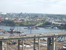
The partially completed bridge in January 2015 | |
| Coordinates | 45°30′21″N 122°39′54″W / 45.5057°N 122.665°WCoordinates: 45°30′21″N 122°39′54″W / 45.5057°N 122.665°W |
| Carries | Planned: TriMet MAX light rail and buses; Portland Streetcar; bicycles and pedestrians |
| Crosses | Willamette River and surface streets |
| Locale | Portland, Oregon |
| Official name | Tilikum Crossing, Bridge of the People |
| Owner | TriMet |
| Characteristics | |
| Design | cable-stayed[1] |
| Total length | 1,720 feet (520 m)[1] |
| Height | 180 feet (55 m)[2] |
| Longest span | 780 feet (240 m)[2] |
| Number of spans | 5[3] |
| Piers in water | 2[3] |
| Vertical clearance | 77.5 feet (23.6 m)[2] |
| History | |
| Construction begin | June 2011 |
| Construction end | 2014 (of bridge only, not surface infrastructure)[2] |
| Opened | September 12, 2015 (projected) |

Tilikum Crossing, Bridge of the People is a bridge under construction across the Willamette River in Portland, Oregon, United States. TriMet, the Portland metropolitan area's regional transit authority, is building the bridge, which will carry TriMet's MAX Orange Line light rail trains, the Portland Streetcar, buses, bicycles, pedestrians, and emergency vehicles. Private cars and trucks will not be permitted on the bridge. The crossing is scheduled to open for general use on September 12, 2015 and will be the first new bridge built across the river in the Portland metropolitan area since 1973.[2][4] The first public access to the bridge will be on August 9, 2015, for the 20th annual Providence Bridge Pedal.[5] It will then be closed until September 12, 2015, the opening date of the MAX Orange Line.
TriMet selected the name of the bridge in April 2014 from a list of four finalists chosen by the public.[6] Tilikum is a Chinook Jargon word meaning people, tribe, or family, and the name is intended to honor the Multnomah, Cascade, Clackamas, and other Chinookan peoples who lived in the area as long as 14,000 years ago.[7] The Tilikum name also references the pervasive use of Chinook Jargon in Portland’s first half century in the frequent trade interactions between pioneers and Native Americans.[8] Before being named, the still-uncompleted bridge had usually been referred to as the Portland–Milwaukie Light Rail Bridge, or as Caruthers Crossing due to its proximity to Caruthers Street.
Route and function
The bridge is south of, and approximately parallel to, the Marquam Bridge. The west "landing" is mid-way between the Marquam and Ross Island Bridges, and the east landing is just north of Southeast Caruthers Street, with the east approach viaduct reaching the surface at the west end of Sherman Street,[2] which the tracks will follow to a new Oregon Museum of Science and Industry (OMSI) MAX station located near an existing Portland Streetcar station and the Oregon Rail Heritage Center.
The alignment was finalized in 2008, after consideration of several alternative alignments.[9][10] However, some studies and public discussion had taken place more than a decade earlier, when a MAX light rail line to Milwaukie was part of the so-called "South/North MAX" project (Vancouver–Downtown Portland–Milwaukie–Clackamas Town Center) for which voters in the Metro district approved funding in November 1994.[11] Alternatives had included routing the proposed MAX line across the existing Hawthorne Bridge and, instead, building a new bridge on any of various alternative alignments, one of which was known as the "Caruthers Street bridge" alignment or simply "Caruthers Bridge" because its east end would roughly align with S.E. Caruthers Street.[12] The "South/North" MAX project was ultimately mothballed after Clark County voters rejected funding their share of the project in 1995 and subsequent efforts by TriMet and Portland officials to secure funding for a scaled-back Vancouver–Portland–Milwaukie MAX line were unsuccessful. However, the planning undertaken during that period included finalizing, by 1998, the choice of a 'Caruthers' alignment for the planned new bridge.[13][14] After planning for a light rail line to Milwaukie resumed, in the early 2000s, the bridge-alignment question was revisited, with a Hawthorne Bridge routing again among the options (because of its much lower cost)[15] but with a new bridge having the widest support.[16] In 2008, the earlier bridge routing choice was reaffirmed, except with the planned west end positioned farther south than previously, so as to better serve the then-new South Waterfront district,[9] where major redevelopment had occurred in the several years since the "South/North" project's planning was undertaken.
Although the planned MAX Orange Line was the impetus for construction of the bridge, the structure will also carry TriMet buses, the Portland Streetcar (planned) and emergency vehicles, and be open for public use by bicyclists and pedestrians. Use by private motor vehicles (except emergency vehicles) will not be permitted.[2] Rerouting of TriMet bus routes onto the new bridge from more-congested crossings will shorten the travel time for about 14,000 daily bus riders.[17] Bike and pedestrian paths will be placed on both sides of the bridge and be 14 feet (4.3 m) wide.[2] The bridge will connect a planned MAX station at OMSI on the east side of the river with a new OHSU/South Waterfront Campus MAX station on the west side.[2] OHSU is the city's largest employer,[18] while OMSI is one of the city's largest tourist and educational venues, and the new bridge will facilitate the connection of both to the regional MAX light rail system. The Orange Line will continue south from OMSI to Milwaukie and northern Oak Grove and north from South Waterfront into downtown Portland.
Design
City planners initially focused on three designs: cable-stayed, wave-frame girder, and through arch,[19] but the design committee eventually recommended a hybrid suspension/cable-stayed design.[20] Despite the recommendation, TriMet chose a cable-stayed option in order to reduce cost.[21]
An aesthetic lighting system will utilize 178 LEDs to illuminate the cables, towers, and underside of the deck. The color and motion of the lighting will change along with the speed, height and water temperature of the Willamette.[22]
Construction

Construction of the bridge is estimated to cost $134.6 million, to be paid for by federal grants, Oregon Lottery revenue and TriMet. Construction of the bridge began in June 2011, with a slow/no wake zone put in place to ensure the safety of river users and bridge construction workers. Beginning in July 2011, an exclusion area around the in-water bridge construction site went into effect. Construction of the bridge itself is scheduled for completion in 2014, followed by several months of work to install tracks and other infrastructure across the bridge,[2] with opening for public use in 2015.[4] The first electrified test train operated over the bridge on January 21, 2015.[23]
The project received required approval from both the Portland and Milwaukie city councils and Oregon's Metro regional governmental agency in 2008.[17][24] TriMet approved a $127 million contract to build the bridge in December 2010.[1]
As part of testing the signaling and overhead catenary systems, MAX and streetcar trains first ran across the bridge under their own power on January 21, 2015.[25][5]
Naming
The public was invited to suggest names for the bridge in the summer of 2013.[26][27] In January 2014, four finalists were chosen:[28]
- Abigail Scott Duniway Transit Bridge: honoring the Oregon pioneer suffragist
- Cascadia Crossing Transit Bridge: in reflection of the bridge's location
- Tillicum Crossing Transit Bridge, Bridge of the People: honoring the indigenous Chinook people; "Tillicum" or "Tilikum" means people, tribe, and relatives in Chinook Jargon
- Wy'east Transit Bridge: Wy'east is the original name of Mount Hood
Public commentary on the names was accepted until March 1 and TriMet chose the final name, Tilikum Crossing, Bridge of the People in April, using the spelling preferred by the Chinookan peoples.[6][27][28][29]
See also
- Gibbs Street Pedestrian Bridge – opened in 2012 and located 600 metres (0.37 mi) south of Tilikum Crossing
References
- ↑ 1.0 1.1 1.2 Rose, Joseph (December 8, 2010). "TriMet board gives greenlight to Portland-Milwaukie Light Rail bridge funding". The Oregonian. Retrieved December 11, 2010.
- ↑ 2.0 2.1 2.2 2.3 2.4 2.5 2.6 2.7 2.8 2.9 "Portland–Milwaukie Light Rail Bridge Fact Sheet/August 2013" (PDF). TriMet. August 2013. Retrieved April 19, 2014.
- ↑ 3.0 3.1 "Tilikum Crossing, Bridge of the People". Portland Milwaukie Light Rail Projecr. TriMet. Retrieved 29 April 2015.
- ↑ 4.0 4.1 Rose, Joseph (June 30, 2011). "Construction begins on new light-rail bridge in Portland that will go up 'piece by piece'". The Oregonian. Retrieved June 30, 2011.
- ↑ 5.0 5.1 Tomlinson, Stuart (January 21, 2015). "Portland-Milwaukie light rail: TriMet sends electrified MAX train over Tilikum Crossing". The Oregonian. Retrieved 5 April 2015.
- ↑ 6.0 6.1 Rose, Joseph (April 16, 2014). "Tilikum Crossing: New Portland bridge named after Chinook word for 'people'". The Oregonian. Retrieved April 16, 2014.
- ↑ Rose, Joseph (April 16, 2014). "Tilikum Crossing: Why TriMet chose to honor Native Americans with new Portland bridge name". The Oregonian. Retrieved April 16, 2014.
- ↑ Prince, Tracy J. (February 27, 2014). "Why Tillicum is the right name for TriMet's new bridge: Guest opinion". The Oregonian. Retrieved April 17, 2014.
- ↑ 9.0 9.1 Mortenson, Eric (May 2, 2008). "Panel realigns route of new light-rail span". The Oregonian, p. D1.
- ↑ Rivera, Dylan; and Zuckerman, Peter (July 25, 2008). "Metro: 'Yes' to Milwaukie light-rail line". The Oregonian, p. B1.
- ↑ Oliver, Gordon (November 10, 1994). "One down, more to go for reality of north-south rail line". The Oregonian, p. C10.
- ↑ Oliver, Gordon (October 4, 1994). "Advisors approve rail routes". The Oregonian, p. B5. Excerpt: "The [citizen advisory] committee heard strong support for the so-called Caruthers Bridge, which would cross the Willamette near RiverPlace."
- ↑ Stewart, Bill (June 19, 1998). "Portland officially maps a South-North rail line". The Oregonian, p. B3. Excerpt: "The line will cross the Willamette River via the 'Caruthers Crossing', running from the Oregon Museum of Science and Industry to the western foot of the Marquam Bridge."
- ↑ Young, Bob (June 24, 1998). "The Rumble That Wasn't: The fight over where the south-north light-rail line should cross the Willamette River ends with a whimper. But that doesn't mean the project is completely on-track." Willamette Week.
- ↑ Oppenheimer, Laura (February 17, 2003). "South Corridor MAX plan unveiled". The Oregonian, p. E1.
- ↑ Leeson, Fred (April 6, 2006). "News Update: Cross the river at Caruthers Street?" The Oregonian, Portland "Neighbors" section, p. 21.
- ↑ 17.0 17.1 Larabee, Mark (July 17, 2008). "Portland council approves Willamette bridge, MAX alignment". The Oregonian. Retrieved March 31, 2012.
- ↑ Kleckner, Michael (October 4, 2007). "A new bridge, Portland-style". The Oregonian. Retrieved April 27, 2013.
- ↑ "New Portland bridge designed for commuters, not cars". SmartBrief. 2008-10-08. Retrieved 2008-10-27.
- ↑ Rivera, Dylan (March 4, 2009). "Portland has designs on a new bridge". The Oregonian. Retrieved April 27, 2013.
- ↑ Weinstein, Nathalie (June 24, 2009). "New bridge will have cable-stayed design: Advisory committee chooses cheaper option for multiuse span across Willamette River". Daily Journal of Commerce. Retrieved December 23, 2010.
- ↑ Rose, Joseph (October 15, 2014). "TriMet will test aesthetic 'river mood lighting' on Portland's Tilikum Crossing this week". The Oregonian. Retrieved 5 April 2015.
- ↑ Tomlinson, Stuart (January 21, 2015). "Portland-Milwaukie light rail: TriMet sends electrified MAX train over Tilikum Crossing". The Oregonian. Archived from the original on 2 February 2015. Retrieved 2 February 2015.
- ↑ Graham, Matthew (July 24, 2008). "Metro OKs Portland-to-Milwaukie light rail line alignment". Portland Tribune. Archived from the original on March 2, 2012. Retrieved April 19, 2014.
- ↑ "TriMet tests train, streetcar on new Tilikum Crossing bridge". Progressive Railroading. January 27, 2015. Retrieved 5 April 2015.
- ↑ Redden, Jim (April 24, 2013). "TriMet announces bridge naming process". Portland Tribune. Retrieved April 26, 2013.
- ↑ 27.0 27.1 "Naming process announced for Portland-Milwaukie Light Rail Bridge" (Press release). TriMet. August 16, 2013. Retrieved August 19, 2013.
- ↑ 28.0 28.1 Redden, Jim (January 15, 2014). "Bridge names: Duniway, Cascadia, Tillicum or Wy'east". Portland Tribune. Retrieved April 19, 2014.
- ↑ "Name the Bridge". TriMet. Retrieved April 16, 2014.
External links
| Wikimedia Commons has media related to Tilikum Crossing. |
| ||||||||||||||||||
| |||||||||