Tikopia
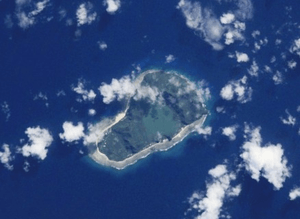
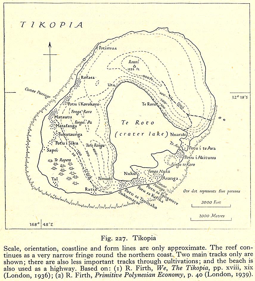
Tikopia is a small high island in the southwestern Pacific Ocean. Covering an area of 5 square kilometers (2 sq. mi.), the island is the remnant of an extinct volcano. Its highest point, Mt. Reani, reaches an elevation of 380 meters (1,247 ft) above sea level. Lake Te Roto covers an old volcanic crater which is 80 metres (260 ft) deep.
The first Europeans arrived on the 22nd of April of 1606 as a part of the Spanish expedition of Pedro Fernández de Quirós.[1]
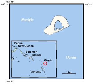
Tikopia's location is relatively remote. It is sometimes grouped with the Santa Cruz Islands. Administratively, Tikopia belongs to Temotu Province as the southernmost of the Solomon Islands. Some discussions of Tikopian society include its nearest neighbour, the even tinier island of Anuta.
A Polynesian outlier
While it is located in the Melanesia region of the Pacific the people of Tikopia are culturally Polynesian. Tikopia is therefore a Polynesian outlier. The linguistic analysis indicates that Tikopia was colonized by seafaring Polynesians, mostly from the Ellice Islands. In Tikopian mythology Atua Fafine and Atua I Raropuka are creator gods and Atua I Kafika is the supreme sky god.
Population

The population of Tikopia is about 1,200, distributed among more than 20 villages mostly along the coast. The largest village is Matautu on the west coast, not to be confused with Mata-Utu, the capital of Wallis and Futuna. Historically, the tiny island has supported a high-density population of a thousand or so. Strict social controls over reproduction prevented further increase. Unlike most of the Solomon Islands, the inhabitants are Polynesians, their language, Tikopian, is a member of the Samoic branch of the Polynesian languages and is generally referred to as a Polynesian outlier.
Tikopians practice an intensive system of agriculture (which has been compared to permaculture), similar in principle to forest gardening and the gardens of the New Guinea highlands. Their agricultural practices are strongly and consciously tied to the population density. For example, around A.D. 1600, the people agreed to slaughter all pigs on the island, and substitute fishing, because the pigs were taking too much food that could be eaten by people.
Unlike the rapidly Westernizing society of much of the rest of Temotu Province, Tikopia society is little changed from ancient times. Its people take great pride in their customs, and see themselves as holding fast to their Polynesian traditions while they regard the Melanesians around them to have lost most of theirs. The island is controlled by four chiefs (ariki) Kifika, Tafau, Taumako and Fangarere, with the ariki Kifika recognised as the first among equals.[2]
Tikopians have a highly developed culture with a strong Polynesian influence, including a complex social structure.
Field work on Tikopia by Raymond Firth
New Zealand anthropologist, Raymond Firth, who lived on Tikopia in 1928 and 1929, detailed the social life of Tikopia at that time. He showed how the society was divided geographically into two zones and was organized into four clans, headed by clan chiefs. At the core of social life was the te paito - the house inherited from male (patrilineal) ancestors, who were buried inside it. Relationships with the family grouping of one's mother (matrilateral relations) were also very important. The relations between a mother's brother and his nephew had a sacred dimension: the uncle oversaw the passage of his nephew through life, in particular, officiating at his manhood ceremonies. Intricate economic and ritual links between paito houses and deference to the chiefs within the clan organization were key dimensions of island life.
Raymond Firth speculates about the ways population control may have been achieved, including celibacy, warfare (including expulsion), infanticide and sea-voyaging (which claimed many youths).
Christianity
The Melanesian Mission (Anglican) first made contact with Tikopia in 1858. A mission teacher was not allowed to settle on Tikopia until 1907.[3] Conversion to Christianity of the total population did not occur until the 1950s.[3]
The introduction of Christianity resulted to the banning of traditional birth control, which had the consequence of a 50% increase of the population: 1,200 in 1920 to 1,800 in 1950. The increase in population resulted in migration to other places in the Solomon Islands including in the settlement of Nukukaisi in Makira.[4]
Currently, many young men leave the island, heading to either the Russell Islands or the national capital, Honiara, in search of work. As a result of this outflow, population control is less necessary.
Cyclone Zoe
Cyclone Zoe in December 2002 devastated the vegetation and human settlements in Tikopia. Despite the extensive damage, no deaths were reported, as the islanders followed their traditions and sheltered in the caves in the higher ground. The narrow bank that separated the freshwater lagoon from the sea was breached by the storm, resulting in the continuing contamination of the lagoon and the threatened death of the sago palms on which the islanders depend for survival. A remarkable international effort by "friends of" the island, including many yacht crews who had had contact with Tikopia over the decades, culminated in the construction of a gabion dam to seal the breach.
See also
- Melanesia
- Oceania
- Pacific Islands
- Polynesian outlier
- Jared Diamond's book Collapse describes Tikopia as a success case in matching the challenges of sustainability, contrasting it with Easter Island.
References
- ↑ Kelly, Celsus, O.F.M. La Austrialia del Espiritu Santo. The Journal of Fray Martín de Munilla O.F.M. and other documents relating to the Voyage of Pedro Fernández de Quirós to the South Sea (1605-1606) and the Franciscan Missionary Plan (1617-1627) Cambridge, 1966, p.39, 62.
- ↑ Macdonald, Judith (2003). "Tikopia". Volume 2, Encyclopedia of Sex and Gender: Men and Women in the World's Cultures. edited by Carol R. Ember, Melvin Ember, Springer. pp. 885–892.
- ↑ 3.0 3.1 Macdonald, Judith (2000). "Chapter 6, Tikopia and “What Raymond Said”". Ethnographic Artifacts: Challenges to a Reflexive Anthropology (PDF). University of Hawaii Press: edited by S. R. Jaarsma, Marta Rohatynskyj. pp. 112–13.
- ↑ Macdonald, Judith (1991). Women of Tikopia. Thesis (PhD - Anthropology) University of Auckland.
External links
- Flaskepost fra stillehavet (Message in a Bottle from the Pacific Ocean) A children's television program produced by NRK about a Norwegian family that spends a year living on the Island.
- An essay on Tikopia, prepared for the BBC
- BBC photo essay, from the aftermath of Cyclone Zoe Despite the overwhelming devastation and the greatest fears, no one on Tikopia was killed in the disaster.
- Tools and practical help after the cyclone
- Restoring the freshwater lagoon of Tikopia
- Solomon Islands - John Seach a Tour Site but with information on each of the islands
- older detail map
Further reading
- Baldwin, James, Across Islands and Oceans, specially chapter 8. Tikopia Unspoilt (Amazon Kindle Book)
- Firth, Raymond (2004), We the Tikopia (reprint ed.), London: Routledge, ISBN 0-415-33020-3, retrieved 18 November 2012 First published 1936 by George Allen & Unwin Ltd. This classic study is still used in contemporary anthropology classes
- Firth, Raymond, The Work of the Gods in Tikopia, Melbourne: Melbourne University Press (1940, 1967)
- Firth, Raymond, SOCIAL CHANGE IN TIKOPIA. Re-Study of a Polynesian Community after a Generation, London: Allen and Unwin. 1959, 360 pages
- Firth, Raymond (2006). Tikopia Songs: Poetic and Musical Art of a Polynesian People of the Solomon Islands. Cambridge University Press.
- Kirch, Patrick Vinton; C. Christensen (1981), Nonmarine mollusks from archaeological sites on Tikopia, southeastern Solomon Island, S. Pacific Science 35:75-88
- Kirch, Patrick Vinton; Yen, D.E (1982), Tikopia; The Prehistory and Ecology of a Polynesian Outlier, Honolulu, Hawaii: Bishop Museum Press, ISBN 9780910240307
- Kirch, Patrick Vinton (1983), Mangaasi-style ceramics from Tikopia and Vanikoro and their implications for east Melanesian prehistory, Indo-Pacific Prehistory Association Bulletin 3:67-76
- Kirch, Patrick Vinton (1986), Tikopia: tracing the prehistory of a Polynesian culture, Archaeology 39(2):53-59
- Kirch, Patrick Vinton (1986), Exchange systems and inter-island contact in the transformation of an island society: The Tikopia case, P. V. Kirch, ed., Island Societies: Archaeological Approaches to Evolution and Transformation, pp. 33-41. Cambridge: Cambridge University Press
- Kirch, Patrick Vinton; D. Steadman and D. S. Pahlavan (1990), Extinction, biogeography, and human exploitation of birds on Anuta and Tikopia, Solomon Islands, Honolulu, Hawaii: Occasional Papers of the Bishop Museum 30:118-153
- Kirch, Patrick Vinton (1996), Tikopia social space revisited, J. Davidson, G. Irwin, F. Leach, A. Pawley, and D. Brown, eds., Oceanic Culture History: Essays in Honour of Roger Green, pp. 257-274. Dunedin: New Zealand Journal of Archaeology Special Publication
- Macdonald, Judith (1991). Women of Tikopia. Thesis (PhD - Anthropology) University of Auckland.
- Macdonald, Judith (2000). "Chapter 6, Tikopia and “what Raymond Said”". Ethnographic Artifacts: Challenges to a Reflexive Anthropology (PDF). University of Hawaii Press: edited by S. R. Jaarsma, Marta Rohatynskyj.
- Macdonald, Judith (2003). "Tikopia". Volume 2, Encyclopedia of Sex and Gender: Men and Women in the World's Cultures. Springer: edited by Carol R. Ember, Melvin Ember. pp. 885–892.
| ||||||||||||||
Coordinates: 12°17′47.3″S 168°49′55.0″E / 12.296472°S 168.831944°E