Tigné
| Tigné | |
|---|---|
|
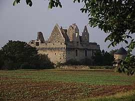
Ruins of Château du Grand-Riou | |
 Tigné | |
|
Location within Pays de la Loire region  Tigné | |
| Coordinates: 47°12′05″N 0°25′38″W / 47.2014°N 0.4272°WCoordinates: 47°12′05″N 0°25′38″W / 47.2014°N 0.4272°W | |
| Country | France |
| Region | Pays de la Loire |
| Department | Maine-et-Loire |
| Arrondissement | Saumur |
| Canton | Vihiers |
| Intercommunality | Communauté de communes du Vihiersois-Haut-Layon |
| Government | |
| • Mayor (2008–2014) | Benoît Onillon |
| Area1 | 16.78 km2 (6.48 sq mi) |
| Population (2006)2 | 754 |
| • Density | 45/km2 (120/sq mi) |
| INSEE/Postal code | 49348 / 49540 |
| Elevation |
37–98 m (121–322 ft) (avg. 59 m or 194 ft) |
|
1 French Land Register data, which excludes lakes, ponds, glaciers > 1 km² (0.386 sq mi or 247 acres) and river estuaries. 2 Population without double counting: residents of multiple communes (e.g., students and military personnel) only counted once. | |
Tigné is a commune in the Maine-et-Loire department in western France.
Geography
The commune is traversed by the river Layon.
See also
References
| Wikimedia Commons has media related to Tigné. |