Thud Ridge
| Thud Ridge | |
|---|---|
|
Location of Thud Ridge | |
| Elevation | 5000 |
| Location | Vietnam |
| Range | Tam Dao range |
| Coordinates | 21°30′22.2″N 105°36′31.02″E / 21.506167°N 105.6086167°ECoordinates: 21°30′22.2″N 105°36′31.02″E / 21.506167°N 105.6086167°E |
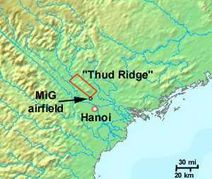
Thud Ridge was the nickname given by United States Air Force F-105 "Thud" pilots during the Vietnam War to the Tam Dao range a 24km, 5000ft high ridge that ran parallel to the Red River approximately 32km northwest of Hanoi, which was both a waypoint during air attacks and a terrain masking feature for ingressing fighters in the vicinity of Hanoi, North Vietnam.[1][2]
The North Vietnamese eventually installed anti-aircraft artillery on the ridge using heavylift helicopters.[3]
Phúc Yên Air Base is located at the base of the ridge, while Kép Air Base is located east of the ridge.
The ridge features heavily in Thud Ridge (book).
References
- ↑ Broughton, Jack (1969). Thud Ridge. J. B. Lippincott Company. ISBN 978-0-85979-116-8.
- ↑ Kelley, Michael (2002). Where we were in Vietnam. Hellgate Press. p. 5-508. ISBN 978-1555716257.
- ↑ "Thuds, the Ridge, and 100 Missions North". Air & Space Magazine. February 2009. Retrieved 4 January 2015.