Thorrington
| Thorrington | |
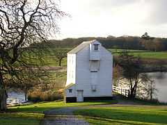 Thorrington Tide Mill |
|
| Shire county | Essex |
|---|---|
| Region | East |
| Country | England |
| Sovereign state | United Kingdom |
| Post town | Colchester |
| Postcode district | CO |
| Dialling code | 01206 |
| Police | Essex |
| Fire | Essex |
| Ambulance | East of England |
| EU Parliament | East of England |
Thorrington is a village and civil parish in the Tendring district of Essex, England. It lies 5 km east of Wivenhoe and 3 km north of Brightlingsea. The striking medieval flint church is dedicated to Mary Magdalene, and the patrons of the church are St John's College, Cambridge.
On the west side, the Tenpenny Brook forms the parish boundary between Thorrington and Alresford. At the point where the brook flows into the Alresford Creek (a branch of the Colne Estuary) stands Thorrington Mill. This is a tide mill built in 1831 and now a Grade II* listed building.
The east and northern boundaries of the parish are bounded by the Saltwater Brook. Where the Saltwater Brook flows into Flag Creek (formerly Borefleet Creek or Byrflytt) is the former site of another Tidal Mill.
The Colchester to Clacton railway line passes just to the north of the village. Thorrington's station was opened in 1867, and closed in 1957.
Great Bentley station is now the closest rail station with parking facilities, located around 2 miles north-east of the village.
Thorrington is also mentioned in the Domesday Book.
Local schools
Great Bentley Primary School is the nearest primary school which serves the catchments of Thorrington, Great Bentley, Frating, Little Bentley and Aingers Green, which caters for around 210 boys and girls aged 4–11.[1] This school was built in 1896 and has recently undertaken some rebuilding work in 2003, maintaining its historic front throughout. Currently, this school is rated good or two in its latest Ofsted inspection report.[2]
Great Bentley Pre School[3] is situated in Great Bentley in the village hall and is a privately owned pre-school which caters for children aged 2–5. This is the nearest pre-school to Thorrington.
Governence
There are several elected representatives at different levels of government which act for Thorrington and the surrounding villages.[4] There are two Thorrington, Frating, Elmstead and Great Bromley district councillors which represent the area at Tendring District Council. The current district councillors are Rosemary Heaney(Conservative) and Fred Nicholls (Conservative).[4]
The current MEPs ( Members of the European Parliament) for this area are Vicky Ford (Conservative), Andrew Duff (Liberal Democrat), Stuart Agnew (UK Independence), Robert Sturdy (Conservative), Geoffrey Van Orden (Conservative), Richard Howitt (Labour) and David Campbell Bannerman (Conservative).[4]
The current Brightlingsea County Councillor which represents the area at Essex County Council is Derek Robinson (Conservative).[4]
The current Harwich and North Essex MP which represents the area in the House of Commons is Bernard Jenkin (Conservative).[4]
Climate
In East Anglia, the warmest time of the year is July and August, when maximum temperatures average around 21 °C (70 °F). The coolest time of the year is January and February, when minimum temperatures average around 1 °C (34 °F) East Anglia's average annual rainfall is about 605 millimetres , with October to January being the wettest months.
| Climate data for East Anglia (1971–2000 averages) | |||||||||||||
|---|---|---|---|---|---|---|---|---|---|---|---|---|---|
| Month | Jan | Feb | Mar | Apr | May | Jun | Jul | Aug | Sep | Oct | Nov | Dec | Year |
| Average high °F (°C) | 44.1 (6.7) |
44.8 (7.1) |
49.8 (9.9) |
54.1 (12.3) |
61 (16.1) |
66.2 (19.0) |
71.2 (21.8) |
71.4 (21.9) |
65.5 (18.6) |
57.9 (14.4) |
49.6 (9.8) |
45.7 (7.6) |
56.8 (13.8) |
| Average low °F (°C) | 34 (1.1) |
33.6 (0.9) |
36.7 (2.6) |
39 (3.9) |
44.1 (6.7) |
49.3 (9.6) |
53.2 (11.8) |
53.2 (11.8) |
49.8 (9.9) |
44.6 (7.0) |
38.5 (3.6) |
35.8 (2.1) |
42.8 (6.0) |
| Average rainfall inches (mm) | 2.102 (53.4) |
1.465 (37.2) |
1.764 (44.8) |
1.783 (45.3) |
1.764 (44.8) |
2.138 (54.3) |
1.811 (46.0) |
1.972 (50.1) |
2.189 (55.6) |
2.323 (59.0) |
2.303 (58.5) |
2.236 (56.8) |
23.85 (605.8) |
| Source: Met Office[5] | |||||||||||||
Related Places
Thorrington was the name of the home of an estate agent, Charles Clark (1824-1906), who arrived in Christchurch, New Zealand, in 1856. Presumably he had a connection with Thorrington in England. He was living at this house at the time of his marriage in 1865. It led to the naming of Thorrington Road in the area, and then to Thorrington School,[6] a primary school on Colombo Street, Christchurch.
References
- ↑ , Great Bentley School, accessed 03 May 2012
- ↑ , Ofsted report, accessed 03 May 2012
- ↑ , Great Bentley Pre School, accessed 03 May 2012
- ↑ 4.0 4.1 4.2 4.3 4.4 Thorrington find your local MP, WriteToThem, accessed 03 May 2012
- ↑ Met Office, Met Office Climate Data,accessed 03 May 2012
- ↑ , Thorrington School, accessed 11 Nov 2013
External links
| Wikimedia Commons has media related to Thorrington. |
- Map sources for Thorrington
- Link to National Archive
- Entry in Kelly's Directory of Essex, 1882
- The mill on the Images of England website
- The mill on the Brightlingsea town website