Thokoza
| Thokoza Kasi laka Gettr | |
|---|---|
|
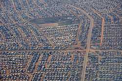
Aerial view of Thokoza | |
 Thokoza
| |
| Coordinates: 26°20′12″S 28°08′48″E / 26.33667°S 28.14667°ECoordinates: 26°20′12″S 28°08′48″E / 26.33667°S 28.14667°E | |
| Country | South Africa |
| Province | Gauteng |
| Municipality | Ekurhuleni |
| Area[1] | |
| • Total | 9.43 km2 (3.64 sq mi) |
| Population (2011)[1] | |
| • Total | 105,827 |
| • Density | 11,000/km2 (29,000/sq mi) |
| Racial makeup (2011)[1] | |
| • Black African | 99.1% |
| • Coloured | 0.4% |
| • Indian/Asian | 0.1% |
| • White | 0.1% |
| • Other | 0.2% |
| First languages (2011)[1] | |
| • Zulu | 40.2% |
| • Sotho | 21.5% |
| • Xhosa | 18.4% |
| • Northern Sotho | 5.4% |
| • Other | 14.5% |
| Postal code (street) | 1426 |
| PO box | 1421 |
Thokoza is a township south of Johannesburg, South Africa at the location of the now defunct Palmietfontein Airport. It is situated south east of Alberton, adjacent to Katlehong on the East Rand, Gauteng, South Africa. Thokoza is the first black township which was established in the East Rand. During the early 90s Thokoza was the middle of a civil war between the supporters of the Inkatha Freedom Party (IFP), rival party of the African National Congress (ANC).[2]
References
| |||||||||||||||||
.svg.png)