Thermopylae

Thermopylae (/θərˈmɒpɨliː/; Ancient and Katharevousa Greek: Θερμοπύλαι [tʰermopýlai], Demotic: Θερμοπύλες [θermoˈpiles]: "hot gateways") is a location in Greece where a narrow coastal passage existed in antiquity. It derives its name from its hot sulphur springs.[1] "Hot gates" is also "the place of hot springs and cavernous entrances to Hades".[2]
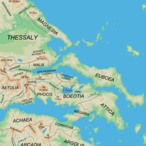
Thermopylae is primarily known for the battle that took place there between the Greek forces including the Spartans and the Persian forces, spawning the famous epitaph beginning with "Go tell the Spartans". It is on the only land route large enough to bear any significant traffic between Lokris and Thessaly. Passage from north to south along the east coast of the Balkan peninsula requires use of the pass. Further west the way is blocked by mountains and the Gulf of Corinth. For this reason the area has been the site of several battles.
The ancient name of the region was Malis after the Malians (Ancient Greek: Μαλιεῖς), a Greek tribe that resided at the mouth of the river Spercheios in Greece. The Malian Gulf is named after them. In the western valley of the Spercheios, their land was adjacent to the Aenianes. Their main town was Trachis. In the town of Anthela, the Malians had an important temple of Demeter, an early centre of the Anthelan Amphictiony.
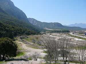
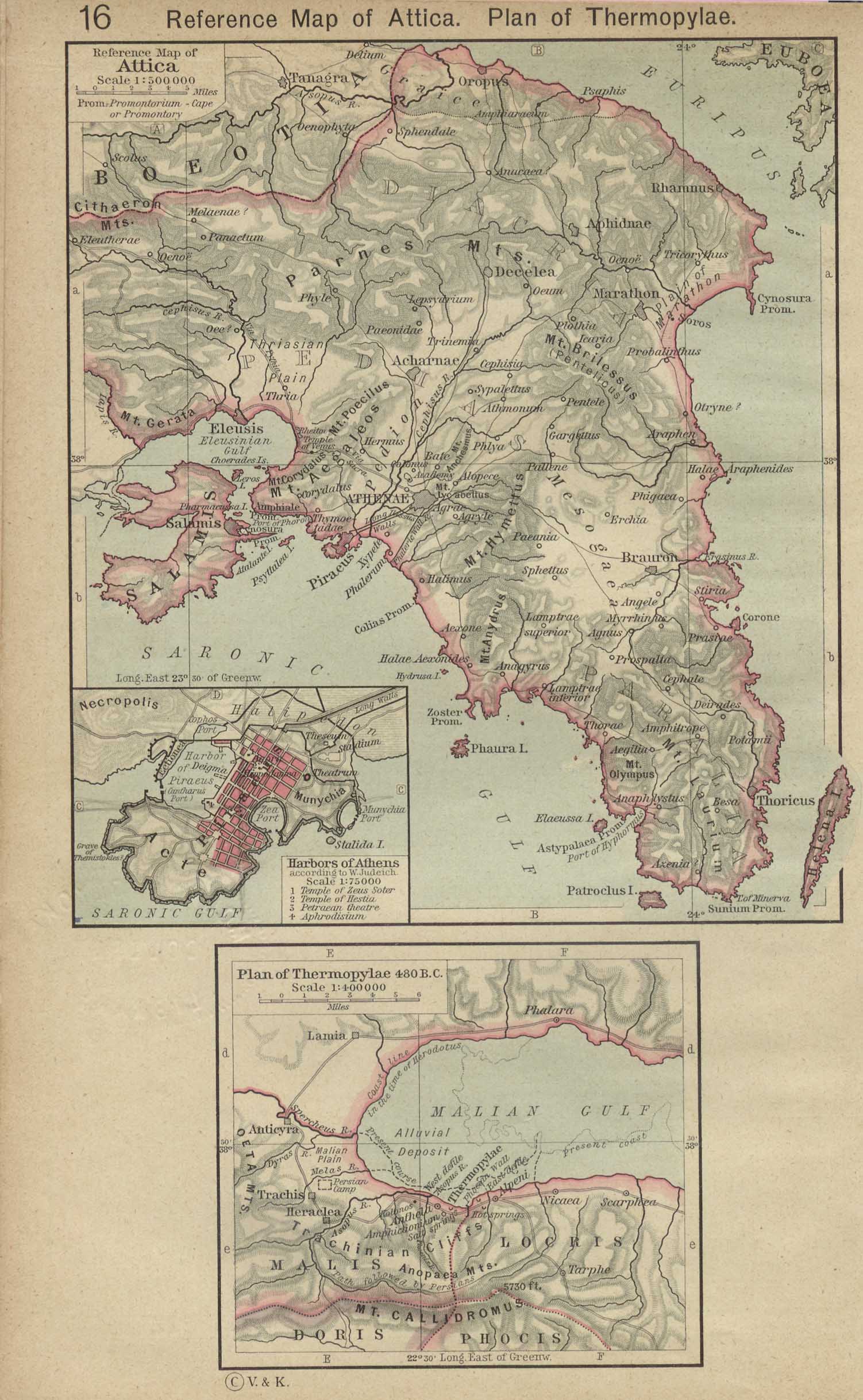
The area is dominated by the coastal floodplain of the Spercheios River, surrounded by steeply sloping forested limestone mountains. The continuous deposition of sediment from the river and travertine deposits from the hot springs has substantially altered the landscape during the past few thousand years. The land surface on which the famous Battle of Thermopylae was fought in 480 BC is now buried under 20 metres (66 ft) of soil. The shoreline has advanced greatly over the centuries because of the sedimentary deposition. The level of the Malian Gulf was significantly higher during prehistoric times and the Spercheios was significantly shorter. The shoreline advanced by up to 2 kilometers between 2500 BC and 480 BC but still left several extremely narrow passages between the sea and the mountains. The narrowest point on the plain, where the Battle of Thermopylae was probably fought, would have been less than 100 metres (330 ft) wide. Between 480 BC and the 21st century, the shoreline advanced by as much as 9 km (5.6 mi) in places, eliminating the narrowest points of the pass and considerably increasing the size of the plain around the outlet of the Spercheios.[3]
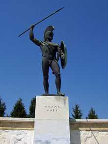
A main highway now splits the pass, with a modern-day monument to King Leonidas I of Sparta on the east side of the highway. It is directly across the road from the hill where Simonides of Ceos's epitaph is engraved in stone at the top. Thermopylae is part of the infamous "horseshoe of Maliakos" also known as the "horseshoe of death": it is the narrowest part of the highway connecting the north and the south of Greece. It has many turns and has been the site of many vehicular accidents.
The hot springs from which the pass derives its name still exist close to the foot of the hill.

Etymology
Thermopylae means "hot gates" in Greek and the name is related with its hot sulphur springs.[1] This is also the place of cavernous entrances to Hades. The first mentioned Amphictyony centered on the cult of Demeter at the city Anthela in the locality of Thermopylae. The delegates to the Amphictiony were entitled Pylagorai (gate-assemblers), perhaps a reference to the local gates of Hades, since Demeter was a chthonic goddess in many of her older local cults.[4]
In a Greek myth is mentioned that Heracles had jumped into the river in an attempt to wash off the Hydra poison infused in the cloak that he could not take off. The river was said to have become hot and stayed that way ever since.
Battles
_p2.342_THERMOPYLAE.jpg)

Greco-Persian Wars
Thermopylae is primarily known for the battle that took place there in 480 BC, in which an outnumbered Greek force probably of seven thousand [5] (including the famous 300 Spartans, 500 warriors from Tegea, 500 from Mantinea, 120 from Arcadian Orchomenos, 1000 from the rest of Arcadia, 200 from Phlius, 80 from Mycenae, 700 Corinthians, 400 Thebans, 1000 Phocians and the Opuntian Locrians ) held off a substantially larger force of Persians.[6] under Xerxes. Probably one thousand Greeks remained in the pass when most of the army retreated.[7]
For three days they held out between two narrow cliff faces to prevent the use of Xerxes' vast cavalry and infantry force, before being outflanked on the third day via a hidden goat path named the Anopaea Pass. According to the Greek legend, a traitor named Ephialtes of Trachis showed the path to the invaders. The following epitaph by Simonides was written on the monument: "Go tell the Spartans, stranger passing by, that here obedient to their laws we lie." (Ὦ ξεῖν', ἀγγέλλειν Λακεδαιμονίοις ὅτι τῇδε κείμεθα, τοῖς κείνων ῥήμασι πειθόμενοι.)
Third Sacred War
In 353 BC/352 BC during the Third Sacred War, fought mainly between the forces of the Delphic Amphictyonic League, principally represented by Thebes, and latterly by Philip II of Macedon, and the Phocians. The war was caused by a large fine imposed on the Phocians in 357 BC for cultivating sacred land. The Spartans, who were also fined in that war, actually never fought in it as they were later pardoned.
Gallic invasion of the Balkans
In 279 BC a Gallic army led by Brennus initially engaged the Aetolians who were forced to make a tactical retreat and who were finally routed by the Thessalians and Malians by the river Spercheios.
Roman-Seleucid Wars
In 191 BC Antiochus III the Great of Syria attempted in vain to hold the pass against the Romans under Manius Acilius Glabrio.
Balkan invasion by the Heruli
In 267, the Germanic tribe of Heruli defeated the Roman force that tried to stop them.
Byzantine-Bulgarian Wars
In 997, the Bulgarian Tsar Samuel invaded Greece and advanced as far as the Peloponnese. On his return, he was met by a Byzantine army under Nikephoros Ouranos at Spercheios. As the river was flooded, both sides encamped on opposite sides without action. Confident that the Byzantines could not cross the river, the Bulgarians relaxed their guard and were taken by surprise when Byzantine scouts discovered a ford further upriver.
Greek War of Independence
In 1821, a force of Greek fighters led by Athanasios Diakos made a stand near the pass to stop a force of 8,000 Turks from marching down from Thessaly to put down revolts in Roumeli and the Peloponnese. Diakos, after making a last stand at the bridge of Alamana with 48 of his men, was captured and killed.
World War II
In 1941 during World War II the ANZAC forces delayed the invading German forces in the area enough to allow the evacuation of the British expeditionary force to Crete. This conflict also became known as the Battle of Thermopylae. Such was the fame of Thermopylae that the sabotage of the Gorgopotamos bridge in 1942 was referred in German documents of the era as "the recent sabotage near Thermopylae".
The Anthelan Amphictiony
An ancient Amphictyony, probably the earliest centred on the cult of Demeter at Anthele (Ἀνθήλη), which lay on the coast of Malis south of Thessaly. This was the locality of Thermopylae. Those living around the temple were named Amphictyones ("dwellers-round").[4][8] The twelve delegates to the Amphictiony met in spring and autumn, and were entitled Pylagorai ("gate-assemblers"). The immediate dwellers-round, presumably the first members were the small states Aeniania, Malis and Doris. Certainly Thessaly did have a share, including the states of the Boeotian tribes who lived around Thessaly (perioikoi, "living around"). Boeotia and Phocis the remotest may have joined during or after the "First Sacred War", which led to the defeat of the old priesthood and to a new control of the prosperity of the oracle at Delphi.[9]
As a result of the war the Anthelan body was known thenceforth as the Delphic Amphictyony and became the official overseer and military defender of the Delphic cult. The name Hellenes, which was originally the name of a Boeotian tribe in Thessalic Phthia, (Achaea Phthiotis) may be related to the members of the league and may have been broadened to refer to all Greeks when the myth of their patriarch Hellen was invented.[10]
See also
Notes and references
- ↑ 1.0 1.1 "Thermopylae" in: S. Hornblower & A. Spawforth (eds.) The Oxford Classical Dictionary, 3rd ed. (Oxford, 1996).
- ↑ L.H. Jeffery (1976) Archaic Greece: The City States c. 700–500 BC. Ernest Benn Ltd., London & Tonbridge p. 73. ISBN 0-510-03271-0
- ↑ Rapp, George Robert; Hill, Christopher L. Geoarchaeology: The Earth-science Approach to Archaeological Interpretation, p. 96. Yale University Press, 2006. ISBN 0-300-10966-0
- ↑ 4.0 4.1 L. H. Jeffery (1976) Archaic Greece: The City States c. 700–500 BC. Ernest Benn Ltd., London & Tonbridge pp. 72-73 ISBN 0-510-03271-0
- ↑ Bradford Ernle (2004). Thermopylae: The Battle for the West. Da Capo Press, p. 106. ISBN 0-306-81360-2
- ↑ Persian Fire. The first great empire and the battle of the West. New York. Doubleday. p. 394 ISBN 0-385-51311-9
- ↑ Green Peter (1996). The Greco-Persian wars. University of California Press. p. 140 ISBN 0-520-20313-5
- ↑ The Parian marble. Entry No 5: "When Amphictyon son of Hellen became king of Thermopylae brought together those living round the temple and named them Amphictyones;
- ↑ L. H. Jeffery (1976) Archaic Greece: The City States c. 700–500 BC. Ernest Benn Ltd., London & Tonbridge pp. 72, 73, 78 ISBN 0-510-03271-0
- ↑ The Parian marble. Entry No 6: "When Hellen son of Deucalion became king of Phthia, the previous naned Graeces were named Hellenes;
Further reading
- Bradford, Ernle Dusgate Selby (1980). The battle for the West : Thermopylae. New York: McGraw-Hill. ISBN 0070070628. OCLC 5889053.
- Cartledge, Paul (2006). Thermopylae. Overlook Press, New York. p. 313. ISBN 1585675660. OCLC 71266590.
- Fields, Nic (2007). Thermopylae 480 BC : last stand of the 300. Oxford: Osprey. ISBN 184176180X. OCLC 148997192.
External links
| ||||||||||||||||||||||||||||||||||||||||||||||||||||||||||||||||||||||||||||||||||||||||||||||||||||||||||||||||||||||||||||||||||||||||||||||||||
Coordinates: 38°48′19″N 22°33′46″E / 38.80528°N 22.56278°E