Thearne

Coordinates: 53°48′59″N 0°22′07″W / 53.816385°N 0.368645°W
Thearne is a hamlet in the East Riding of Yorkshire, England, in the civil parish of Woodmansey.
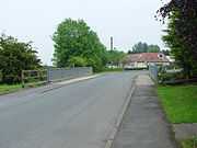
It is situated approximately 3.5 miles (5.6 km) south-east of Beverley to the east of the A1174 road from Hull to Beverley. It also lies just to the west of the River Hull.
Geography
Thearne lies between the A1174 Beverley to Hull road, and the River Hull, around 3.5 miles (5.6 km) south-east of Beverley. The original village is located at the meeting of three minor roads: Thearne Road (now Ferry Road) and Thearne Lane (formerly Old Wire Carr Road) to the west, and Ferry Road to the east. The modern place includes additional housing along the A1174.[2][3]
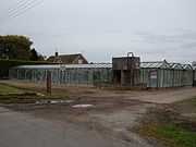
The area around Thearne is primarily agricultural, low lying (less than 5m above sea level), with extensive drainage. There are several developments of glasshouse based agriculture in the area.[2]
Governance
The hamlet was in the Beverley and Holderness parliamentary constituency until the 2010 general election when it was transferred to the constituency of Haltemprice and Howden.[1]
History
The name 'Thearne' is a reference to the Thorn tree and was recorded as early as the late 1200s.[4] A ferry east of Thearne across the river Hull dates to at least the 1100s.[4] In the 1400s a chapel dedicated to the Blessed Virgin was established. The chapel was confiscated during Henry VIII's suppression, and is no longer in existence.[4]
Flooding of the Beverley-Hull road led to orders for an improvement of the area's drainage in the 17th century. The land around Thearne was enclosed by and act of 1788. The Beverley and Barmston drain was constructed through the area in around 1800, but does not actively drain Thearne.[4] A windmill for corn, Thearne Windmill, south-west of the village on the Beverley-Hull road was constructed sometime around 1800.[3][4] An earlier mill existed in the 17th century, the new mill had steam power installed in 1856.[4]
In 1821 the population of Thearne was 90;[5] by around 1833 the township had a population of 67.[6][7] In the 1850s Thearne consisted of less than 10 main buildings, including Thearne Hall. (built c. 1823.[8]) A Primitive Methodist chapel was built in 1867.[8] Ferry Road led east to the River Hull where the ferry ('Waghen ferry' later 'Wawne Ferry') crossed to the Anchor Inn (later the Windham Arms), and to the road to Wawne.[3][9]
By the 1920s Thearne Windmill was out of use.[10] The ferry closed in the 1950s.[4] A waste water treatment works for Woodmansey and Thearne was constructed in the 1950s, northeast of the village.[4][11] The Methodist chapel closed in 1968.[4]
Glasshouse agriculture developed extensively around Wawne in the second half of the 20th century.[12]
|

References
- ↑ 1.0 1.1 "Are you ready to vote in the next election?". East Riding News (East Riding of Yorkshire Council): p. 3. April 2010.
- ↑ 2.0 2.1 Ordnance Survey. 1:25000. 2006; also OS Open Data
- ↑ 3.0 3.1 3.2 Ordnance Survey. 1852 Sheet 211
- ↑ 4.0 4.1 4.2 4.3 4.4 4.5 4.6 4.7 4.8 Baggs et al. 1989.
- ↑ Oliver, George (1829). The history and antiquities of the town and minster of Beverley .. p. 516.
- ↑ Lewis, Samuel (1833). A Topographical Dictionary of England: With Historical and Statistical Descriptions. THEARNE.
- ↑ White, William (1840). History, Gazetteer and Directory of the East and North Ridings of Yorkshire.
- ↑ 8.0 8.1 Pevsner, Nikolaus; Neave, David (1995). Yorkshire: York and the East Riding. The Buildings of England (2nd ed.). p. 765.
- ↑ Ordnance Survey. 1908-10. Sheet 211.SW
- ↑ Ordnance Survey. 1926. Sheet 211.SW
- ↑ Ordnance Survey. 1972. 1:2500
- ↑ Ordnance Survey. 1:10000. 1956, 1974, 1984, 1989
Sources
- Gazetteer — A–Z of Towns Villages and Hamlets. East Riding of Yorkshire Council. 2006. p. 11.
- Baggs, A.P.; Brown,, L.M.; Forster, G.C.F.; Hall, I.; Horrox, R.E.; Kent, G.H.R.; Neave, D. (1989). "Thearne and Woodmansey". In Allison, K.J. A History of the County of York East Riding: The borough and liberties of Beverley 6.
External links
![]() Media related to Thearne at Wikimedia Commons
Media related to Thearne at Wikimedia Commons
| ||||||||||||||||||||||||||